
21.5
PDI
14.7 mi
DISTANCE
4,076 ft
GAINED
5.2 %
AVG. GRADE
FULL CLIMB STATS
INTRO
PLAN YOUR ROUTE
 We've partnered with Sherpa-Map.com to bring you the best route planning tool. With a PRO Membership you can use this climb as a reference when creating your route.
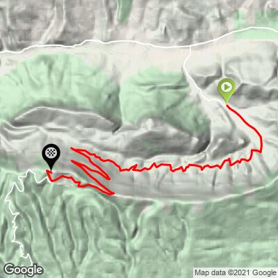
 The climb averages 5.2% over 23.7 km (14.7 mi), and it is anything but uniform. The first 3 km (1.9 mi) run 5-7%, with the steepest of that section about 7% near 2-3 km (1.2-1.9 mi). From roughly 3.5 to 9 km (2.2-5.6 mi) the road rolls and flattens as it crosses the hillside; the easiest kilometer is under 1%, near 7 km (4.3 mi).
From about 9 km (5.6 mi) the grade holds a steady 5-6% for around 14 km (8.7 mi), reaching 7.0% near 16-17 km (9.9-10.6 mi), and the road kicks up to about 8% in the last kilometer to the top. Our data has the steepest half kilometer (0.3 mi) at 11.1%, the steepest kilometer (0.6 mi) at 8.8%, the steepest 2 km (1.2 mi) at 6.9%, the steepest 5 km (3.1 mi) at 6.4% and the steepest 10 km (6.2 mi) at 6.1%.
Roadway: The road is paved all the way, but the surface is mixed: smoother, newer asphalt in places, coarse and rough asphalt in others, and the last stretch beyond the Pas de la Graille narrows to a small, rough road near the top. Descend with care, particularly through the upper kilometers. The Lure is exposed and snow-bound in winter, so the practical riding season runs roughly from May to September.
Traffic: Very light. Most of the road sees only a few cars, and riders often have long sections to themselves. There is somewhat more activity around the Pas de la Graille, the trailhead for walks along the Lure ridge.
Parking: Les Tournières is a small hamlet in the Jabron valley, so use courteous roadside parking, keep driveways and field gates clear, and consider setting up in Valbelle, where there is drinking water, before riding to the start.
Provisions: There are no services on the climb, and water is available in Valbelle, so leave with two full bottles for a ride that takes most riders well over an hour and a half. Sisteron, about 7 km (4.3 mi) away, has the shops and restaurants.
Gear: A compact crankset is plenty for the 5-7% grades, though a 30 to 32 tooth cog is welcome late in the day. The last kilometers are exposed and often windy, and the summit is much cooler than the valley, so carry a windproof layer. If you have wider tires, they help on the rough upper surface and on the descent.
Before heading out on any cycling adventure check out our Things to Bring on a Cycling Trip and use our interactive check list to ensure you don't forget anything.
Valbelle is a small commune of a few hundred people closed in by the Lure, made up of three hamlets, Les Escoffiers, Les Richaud and Les Tournières, that now run together into one village. Its parish church dates from the 15th to 17th centuries, the remote Chapelle Saint-Pons has an 11th-century apse, and a ruined 13th-century tower, the Tour Vieille, watches over the entrance to the valley.
Sisteron, roughly 7 km (4.3 mi) away, is the practical base for lodging and supplies. For a very different feel, the south side of the mountain from Saint-Étienne-les-Orgues is shorter and steeper; see our Signal de Lure (Saint-Étienne-les-Orgues) page. Our Montagne de Lure (Valbelle) page starts from the village itself.
Conditions on the ridge can differ sharply from the valley, so check the forecast before you go with our Weather tool.
ROUTE MAP
MEMBER RATING
CURRENT WEATHER
PJAMM TRIPS ADVENTURE STARTER BUNDLES
Check out PJAMM Adventure's prepackaged (self-guided) cycling trips. They will help you plan, document and conquer your next adventure.
NEARBY CLIMBS (0) RADIAL PROXIMITY
FROM No Climbs Found
MEMBER REVIEWS & COMMENTS
Let us know what you thought of this climb. Signup for our FREE membership to write a review or post a comment.
Already have an account?
LOG IN HERE
