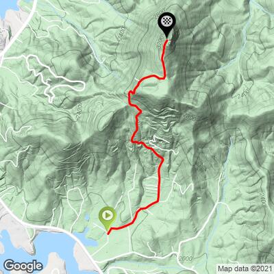
Bell Mountain Bike Climb - PJAMM Cycling

5.2
FIETS
2.1 mi
DISTANCE
1,377 ft
GAINED
12.5 %
AVG. GRADE

FULL CLIMB STATS

Page Contributor(s): Tracy Swain, Dahlonega, Georgia; Alex Berry, Roswell, Georgia; Dan Razum, San Jose, CA

INTRO

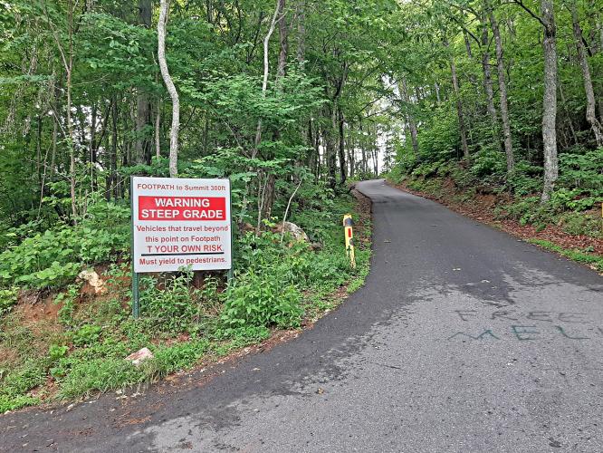
This is a Georgia bucket list bike climb.  Ride a steep grade on the #1 ranked bike climb in Georgia up to a summit platform with extraordinary views. 

See more details and tools regarding this climb's grade via our interactive Profile Tool.
Information Not Available

If you have any information regarding this climb, we'd like to hear from you. Click the CONTRIBUTE button to share your thoughts with us.

Information Not Available

If you have any information regarding this climb, we'd like to hear from you. Click the CONTRIBUTE button to share your thoughts with us.

Before heading out on any cycling adventure check out our Things to Bring on a Cycling Trip and use our interactive check list to ensure you don't forget anything.
Information Not Available

If you have any information regarding this climb, we'd like to hear from you. Click the CONTRIBUTE button to share your thoughts with us.

ROUTE MAP

MEMBER RATING

Difficulty: Extreme
4
Road
5
Traffic
5
Scenery

CURRENT WEATHER

PJAMM TRIPS ADVENTURE STARTER BUNDLES

Check out PJAMM Adventure's prepackaged (self-guided) cycling trips. They will help you plan, document and conquer your next adventure.
ALL TRIPS
Browse all of our prepackaged trips and find your next adventure!
Smoky Mountain National Park
United States (NC,TN)
17 ROUTES
31 POIs
ROUTE STATS (TOTAL)
181.8
mi
DISTANCE
34,253
ft
ELEV. GAIN

NEARBY CLIMBS (0) RADIAL PROXIMITY

FROM
No Climbs Found

MEMBER REVIEWS & COMMENTS

Let us know what you thought of this climb. Signup for our FREE membership to write a review or post a comment.
Already have an account?

Jul 13, 2023
difficulty: Extreme
scenery: 5
traffic: 5
road: 4
Jul 13, 2023
scenery: 5
traffic: 5
road: 4
June 16, 2023 Parked at the bottom of the climb at the public boat ramp. You're a beast if you can climb from the bottom to the very top parking area without stopping. You'll need compact or sub-compact gearing to tame this monster climb. After a mild start, the climb hits you hard with steep steep steep climbing up to a lower parking area - only chance to catch your breath before the last steep climb to the summit parking lot. A very enjoyable sufferfest for sure ! Highly recommended. I did this climb the same day after doing the Brasstown Bald climb. Both are nearby with an easy drive. Bell Mountain is definitely harder.
ROUTE MAP
PROFILE TOOL
Route Data
S.G. (%)
hide
Segment Data
hide

Climb Profile Not Found
CLIMB SUMMARY

panoramic view looking down mountainside, graffitied rocks

Cycling Bell Mountain, Georgia

Ride just 2.1 miles but gain 1,377’ at 12.5% average grade.

Bell Mountain is a beast and the undisputed hardest bike climb in all of Georgia. There is a quarter-mile beginning at mile 1.3 that averages 19.4%, and a fule mile averaging 17% from mile 0.5 to 1.5.

photo collage; warning signs for Steep Grade

This is an epic climb ending at Bell Mountain Summit and observation platform.

view looking down from mountain top at extremely steep grade up roadway

Normally a photo doesn’t capture true grade - this one does!

Climb summary by PJAMM ambassador Dan Razum of San Jose, California:

Bell Mountain is a stout climb, you definitely want to make sure that you have low gears on your bike for this one.  The first half-mile or so isn't bad, but after that it doesn't let up until you reach the summit.

photo collage shows extremely forest-covered roadway, one-lane roadway; sign warns "Narrow lane Road Watch for Pulloffs"

We start climbing along a residential area with a fair number of houses along the way. As we climb, the houses thin out. The road condition is decent but narrow, so beware of any descending cars.  We didn't encounter any traffic on a weekday morning, but there is a nice scenic view at the top, so there could be traffic on the weekends.

photo collage shows narrow one-lane densely forested road; road sign warns to watch for pedestrians

Bottom left photo - while the dog gets a bit of relief, we get none on this brutal climb . . .

As we passed a house along the way, a dog saw us and came out to investigate. We were a little cautious at first, because dogs and cyclists don't always mix well, but there was nothing to worry about.  The dog graciously guided us to the summit. Being a local dog, he knew the road better than us and we had a hard time keeping up with him! But he did his

job well and kept the road clear of any pesky squirrels or birds.

photo collage shows views leading up to summit; extremely steep grade, warning signs, roadway and rocks up to summit covered in spray paint and graffiti

There is a small parking area near the top and another larger parking area at the end of the pavement. There is a small overlook and a staircase to the summit itself.  We definitely recommend climbing the stairs to the top as there are amazing 360 degree views from there. The rocks around the parking lot, as well as the staircase itself, are full of graffiti, despite several signs prohibiting any spray paint.  The graffiti is rather interesting and artistic, although local officials may feel otherwise.

photo collage from Hal Herrin Overlook at climb's finish; graffiti on 360 degree lookout viewpoint

Views from the Hal Herrin Scenic Overlook at the top of the climb.

4.8 Google Reviews

The descent is rather technical, so be sure to exercise caution on the way down.