5.3
PDI
2.5 mi
DISTANCE
883 ft
GAINED
6.7 %
AVG. GRADE
FULL CLIMB STATS
INTRO
This 2.5 mile bike climb is located in MD, USA. The average gradient is 6.7% and there is a total elevation gain of 883 ft, finishing at 1,582 ft.
Use the profile tool, route map, and weather forecast to conquer this cycling climb.
Use the profile tool, route map, and weather forecast to conquer this cycling climb.
PLAN YOUR ROUTE
This climb averages 0%. The steepest quarter mile of this climb is 0%. NaN miles of the climb is at or above 10% grade. The gradient on this climb is broken down as follows:
See more details and tools regarding this climb's grade via our interactive Profile Tool.
See more details and tools regarding this climb's grade via our interactive Profile Tool.
Information Not Available
If you have any information regarding this climb, we'd like to hear from you. Click the CONTRIBUTE button to share your thoughts with us.
Information Not Available
If you have any information regarding this climb, we'd like to hear from you. Click the CONTRIBUTE button to share your thoughts with us.
Before heading out on any cycling adventure check out our Things to Bring on a Cycling Trip and use our interactive check list to ensure you don't forget anything.
Information Not Available
If you have any information regarding this climb, we'd like to hear from you. Click the CONTRIBUTE button to share your thoughts with us.
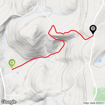
ROUTE MAP
MEMBER RATING
CURRENT WEATHER
PJAMM TRIPS ADVENTURE STARTER BUNDLES
Check out PJAMM Adventure's prepackaged (self-guided) cycling trips. They will help you plan, document and conquer your next adventure.
NEARBY CLIMBS (0) RADIAL PROXIMITY
FROM No Climbs Found
MEMBER REVIEWS & COMMENTS
Let us know what you thought of this climb. Signup for our FREE membership to write a review or post a comment.
Already have an account?
LOG IN HERE
chblue321
The fishers section was good clean asphalt. The highland section was gritty chipseal; no problem climbing but be careful descending
arielatom
This is one of the main alternatives to Coxey Brown, and I find this climb to be more fun as well. It's prettier and although easier it never fails to offer enough of a challenge. The road kicks up for a steep ramp after passing a lone house on the right to start turning on the hurt, and then it stair steps its way to the top of that portion. If you're going for a PB or KOM here, you need to keep just enough in reserve on Fishers Hollow for steadier but still reasonably steep climbing on Highland School Rd.