
38.9
PDI
7.4 mi
DISTANCE
4,298 ft
GAINED
10.7 %
AVG. GRADE
FULL CLIMB STATS
Page Contributor(s): Ard Oostra, Switzerland
INTRO
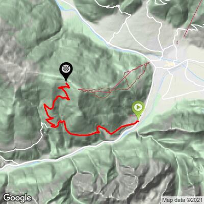
Hochstein Parkplatz is a short, brutally steep climb above Lienz in East Tyrol (Osttirol), climbing 4,298 feet in just 7.4 miles at a 10.7% average grade. It starts in the valley near Leisach, follows the Pustertaler Hohenstrasse up to the hamlet of Bannberg, then turns onto the private Hochstein toll road for the final, steepest push to the parking area at nearly 6,500 feet.
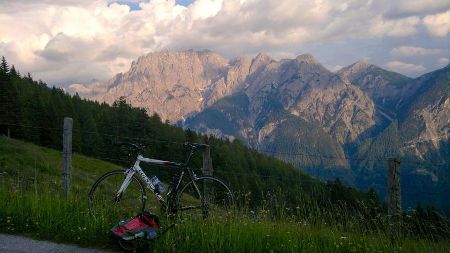
What makes this climb distinctive is how little relief it gives - after the opening miles through the valley, the toll road above Bannberg winds up through a long series of hairpins with almost no flat sections, gaining most of its 4,298 feet in the final few miles. The reward is a big payoff in views: the road looks out over the Lienzer Dolomiten and the Lienz valley the whole way up, and the parking area sits just below the Hochsteinhutte, a mountain hut perched at over 6,600 feet.
Hochstein is better known locally as a hiking and mountain biking destination - the Dolomitenmann adventure race and the Transalp mountain bike route both pass through here - but the paved toll road to the parking area is entirely open to road cyclists as well.
PLAN YOUR ROUTE
 We've partnered with Sherpa-Map.com to bring you the best route planning tool. With a PRO Membership you can use this climb as a reference when creating your route.
 This climb averages 10.7% over 7.4 miles, gaining 4,298 feet - one of the steepest sustained grades in this part of the Alps. The lower section from near Leisach up to Bannberg on the Pustertaler Hohenstrasse is the gentlest part of the ride.
Once the road turns onto the toll road above Bannberg, the grade tightens noticeably and stays in double digits almost continuously through a long series of hairpins, with sections reported to hit 12% before easing slightly in the final approach to the parking area.
There's very little flat or downhill relief anywhere on the toll-road section, so this is a climb that rewards a steady, conservative pace over the opening miles.
Roadway: Fully paved from start to finish. The lower section follows the Pustertaler Hohenstrasse, a normal two-lane road, before the route turns onto the private Hochstein toll road above Bannberg - narrower, with frequent hairpins, but well-maintained tarmac throughout.
Traffic: Light. The Pustertaler Hohenstrasse carries some local and tourist traffic, but the Hochstein toll road above Bannberg sees very little beyond visitors headed to the Hochsteinhutte or the bike park, since through-traffic is filtered out by the toll barrier. The road is only open seasonally, from around May 1 to October 31, so there's no traffic to worry about outside that window because the gate is simply closed.
Parking: There's parking in Leisach or on the outskirts of Lienz near the start if arriving by car. The toll road itself charges cars a fee at an automated barrier, but cyclists are waved through for free, so there's no cost to ride it - just continue past the barrier to the parking area at the top.
Lienz, just a couple of miles from the start, has full services - bike shops, supermarkets, and cafes - so stock up there before heading out. Once past Bannberg there's nothing until the top, and the parking area itself has no shops, though the Hochsteinhutte a short walk above it serves food and drinks in season.
Given the sustained double-digit grade, a compact crank or wide-range cassette is worth having, and pack a light jacket for the descent - temperatures at nearly 6,500 feet can be noticeably colder than in Lienz.
Before heading out on any cycling adventure check out our Things to Bring on a Cycling Trip and use our interactive check list to ensure you don't forget anything.
Lienz is the closest base, with a full range of hotels and restaurants and easy access to several other climbs in the Lienz Dolomites, including the nearby Zettersfeld.
The Hochstein toll road is only open from about May 1 through October 31, so plan a visit inside that window - outside it, the gate stays closed and the road is used by hikers and skiers instead. Innsbruck is the nearest major airport, roughly a 2 - 2.5 hour drive away. See more of what else is climbable nearby with our Routes in the Area tool!
ROUTE MAP
MEMBER RATING
CURRENT WEATHER
PJAMM TRIPS ADVENTURE STARTER BUNDLES
Check out PJAMM Adventure's prepackaged (self-guided) cycling trips. They will help you plan, document and conquer your next adventure.
NEARBY CLIMBS (0) RADIAL PROXIMITY
FROM No Climbs Found
MEMBER REVIEWS & COMMENTS
Let us know what you thought of this climb. Signup for our FREE membership to write a review or post a comment.
Already have an account?
LOG IN HERE
