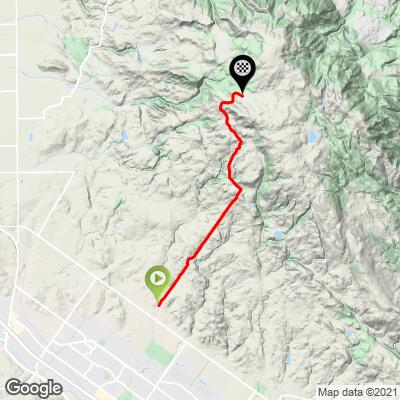
Sonoma Mountain Road West Bike Climb - PJAMM Cycling

3.6
FIETS
5.2 mi
DISTANCE
1,892 ft
GAINED
6.6 %
AVG. GRADE

FULL CLIMB STATS

INTRO

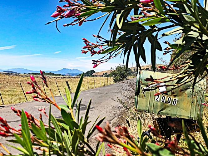
This climb ranks #8 on the Sonoma County climb list. The climb passes through classic Sonoma County pastureland (yes, not vineyard!) and is fairly remote, with minimal traffic. Through the middle portion of the ride (~ miles 3-4), there are very scenic views west towards Old Adobe Road, Petaluma, Mt. Tamalpais 25 miles south and Mt. St. Helena 25 miles to the north. This is a scenic ride where we are surrounded the entire trip by open fields and distant views of open space. The climb has some severe grades along two 50 yard segments.
6.8% average grade (8.1% with descent eliminated). 31% is at 0-5% average grade, 31% is at 5-10%, 13% is at 10-15%, and 14% is at 15-20%.  The steepest quarter-mile is 17.6% and steepest mile 12.6%.

See more details and tools regarding this climb's grade via the “Profile Tool” button.
Roadway:  Poor condition double lane rural roadway with no center stripe.

Traffic:  Mild.

Parking:  Just past the start of the climb on the left - Map; Street View
Information Not Available

If you have any information regarding this climb, we'd like to hear from you. Click the CONTRIBUTE button to share your thoughts with us.

Before heading out on any cycling adventure check out our Things to Bring on a Cycling Trip and use our interactive check list to ensure you don't forget anything.
If you have travelled to Sonoma County to cycle or have any questions concerning cycling in the North Bay, you are welcome to contact me at john@pjammcycling.com with your questions about the area - I grew up and live in Sonoma and have good knowledge of cycling in this region.

Use the “Routes in Area” button on the menu bar above to see other bike climbs in this area.

ROUTE MAP

MEMBER RATING

Difficulty: Strenuous
3
Road
4
Traffic
5
Scenery

CURRENT WEATHER

PJAMM TRIPS ADVENTURE STARTER BUNDLES

Check out PJAMM Adventure's prepackaged (self-guided) cycling trips. They will help you plan, document and conquer your next adventure.
ALL TRIPS
Browse all of our prepackaged trips and find your next adventure!
San Francisco Bay Area
United States (CA)
25 ROUTES
30 POIs
ROUTE STATS (TOTAL)
487.9
mi
DISTANCE
65,482
ft
ELEV. GAIN
Sonoma County
United States (CA)
19 ROUTES
39 POIs
ROUTE STATS (TOTAL)
269.3
mi
DISTANCE
41,801
ft
ELEV. GAIN

NEARBY CLIMBS (0) RADIAL PROXIMITY

FROM
No Climbs Found

MEMBER REVIEWS & COMMENTS

Let us know what you thought of this climb. Signup for our FREE membership to write a review or post a comment.
Already have an account?

May 25, 2021
difficulty: Strenuous
scenery: 5
traffic: 4
road: 3
May 25, 2021
scenery: 5
traffic: 4
road: 3
This was far more difficult than I expected primarily due to the series of steep pitches, several of which exceed 20% and the 1/4 mile of each that is at least 15%. Once they are handled the remainder is not bad. Fair number of service trucks but tolerable. The scenery is worth it with views of Mt. Tam, San Francisco Bay, Mount Saint Helena, and the Santa Rosa Plain. Potholes are filled in but still bumpy in places.
ROUTE MAP
PROFILE TOOL
Route Data
S.G. (%)
hide
Segment Data
hide

Climb Profile Not Found
CLIMB SUMMARY

Cycling Sonoma Mountain Road West

Ride 5.2 miles gaining 1,950’ at 6.8% average grade.

Sonoma Mountain Road West is the eighth most difficult bike climb in Sonoma County, with a Fiets Index of 3.8. The climb passes through classic Sonoma County pastureland (yes, not vineyard!) and is fairly remote, with minimal traffic.  

Through the middle portion of the ride (~ miles 3-4), there are very scenic views west towards Old Adobe Road, the historic farming town of Petaluma, Mt. Tamalpais 25 miles south, and Mt. St. Helena 25 miles north.  

Beautiful (and rustic) Sonoma County farmland.

This is a scenic ride where we are surrounded the entire trip by rolling hills, fields, and distant views of open space.  Toward the top of the mountain climb, riders can expect to see 180-degree views stretching from Santa Rosa all the way to the San Pablo Bay.  On an clear day, it’s possible to see as far south as the rust-colored arches of the Golden Gate Bridge.  The climb has some severe grades along two 50 yard segments.  It also has four segments of 100 to 400 yards that average over 16% (the steepest quarter mile on the climb averages 17.6%).


Traffic and Roadway Surface Report:  There is very little traffic along this very narrow roadway (wide single-lane, or narrow two-lane).  The roadway surface is extremely poor and there is quite a bit of loose gravel, as well as deep potholes, which justify using extreme caution on the descent.  Though the gorgeous views may tempt you, it is advisable to keep your eyes on the road during the descent so you can avoid any potentially dangerous rough patches of pavement.

Rough road and all, this is one fantastic bike ride.

That’s a wrap!

Access to full Climb Summary requires a PJAMM Cycling PRO Membership!

It takes less than a minute to sign up & with your PRO membership you can:
  • Rate climbs, post comments and share your experiences on any of our climb pages
  • Create bucket lists of climbs & mark the dates you complete them
  • Weather data for all climbs - Start & Finish
  • Upload photos to your member page to customize your PJAMM Cycling experience
  • Utilize all of our interactive tools - Profile & Routes in Area
  • Download climb route .gpx files
LEARN MORE
SIGN UP

Already have an account? LOG IN HERE