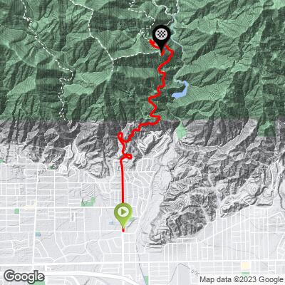
11.6
PDI
5 mi
DISTANCE
1,871 ft
GAINED
7.1 %
AVG. GRADE
FULL CLIMB STATS
INTRO
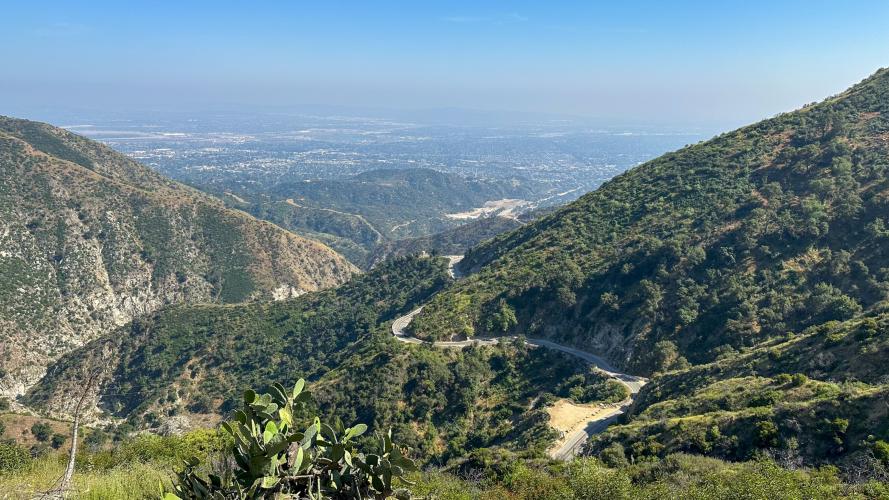
After several years of closure (Covid-19, the Bobcat Fire, then the Eaton Fire), one of LA's favorite climbs is back open. This is one of the most popular climbs in the San Gabriel Mountains, as its fairly easy, has extraordinary views, and virtually no traffic on the weekdays. Weekends can get busy, but it's worth it anyway - the Adams Pack Station is a party!
PLAN YOUR ROUTE
See more details and tools regarding this climb's grade via our interactive Profile Tool.
Roadway
Roadway has been recently repaired after wildfires/landslides. It's very smooth and makes for one of the best descents in the San Gabriels.Traffic
Virtually none on weekdays, can be quite heavy on weekends, since at the top is a very popular trailhead.
Parking
Park in any neighborhood near the bottom of the climb, or alternatively, the nearby Sierra Vista Park.
There is a restaurant, the Adams Pack Station at the top, serving food, drinks, cold beer, and has live music on the weekends.
Before heading out on any cycling adventure check out our Things to Bring on a Cycling Trip and use our interactive check list to ensure you don't forget anything.
We highly recommend the Mt Wilson hike starting at Adams Pack Station. From here you can hike a 12.5 mile loop up to the Mt Wilson Observatory at the peak, eat lunch at the Cosmic Cafe, and pass Sturtevant Falls along the way. Parking is busy on weekends, so start early!
ROUTE MAP
MEMBER RATING
CURRENT WEATHER
PJAMM TRIPS ADVENTURE STARTER BUNDLES
Check out PJAMM Adventure's prepackaged (self-guided) cycling trips. They will help you plan, document and conquer your next adventure.
NEARBY CLIMBS (0) RADIAL PROXIMITY
FROM No Climbs Found
MEMBER REVIEWS & COMMENTS
Let us know what you thought of this climb. Signup for our FREE membership to write a review or post a comment.
Already have an account?
LOG IN HERE
wmateer2

The road is open as of October 2, 2024. Lots of resurfaced sections up to the parking lot. Adams Pack Station (at the parking lot) is open, at least for now. Final 3/4 mile is still a bit rough.
carbon23
Scenery gets beautiful as you get further back into the canyon. Road is not in great condition so be careful on the descent. The road has been closed for quite some time since the fires in September of 2020. Do not chance it as I believe it's a $5,000 fine to go around the barrier (it's very obvious where it's closed). I think they plan on having the road closed for 3 years or so.