
24.3
PDI
19 mi
DISTANCE
4,880 ft
GAINED
4.6 %
AVG. GRADE
FULL CLIMB STATS
INTRO
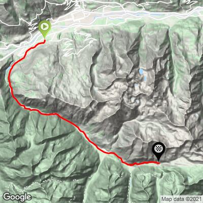
Jovencan to Crete is a 30.5 km (19.0 mi) climb from the village of Jovençan, just southwest of Aosta, deep into the Cogne valley, gaining 1,487 m (4,880 ft) at a 4.6% average to finish at 2,012 m (6,601 ft) above the hamlet of Lillaz. It's a long, uneven effort rather than a steady grind: the lower half follows the Grand Eyvia gorge on the SR47 regional road - including a short descent near km 8 - before long, moderate grades carry you up to Cogne, the valley's main town and one of the classic gateways to Gran Paradiso National Park.
The real character of the climb shows up after Lillaz. Beyond the village, a narrow farm road leaves the valley floor and switchbacks steeply into the Urtier valley - two straight kilometers average around 10% - before the pavement gives way to nearly 2 km of fairly easy gravel for the final push toward Plan des Goilles. This upper section is very popular with mountain bikers, and we even met a few road cyclists up here, though most of them likely didn't go as far as we did. It was the only climb of our day with nothing above 20%, and the nicest of the lot.
The Cogne road has been rebuilt in stages since the 2024 floods, and it is the only road access into the valley. In 2026 the temporary Bailey bridge at Chevril was removed as the permanent crossing neared completion, and the Grand-Bois variant near km 9.4 of the SR47 reopened in June - so expect the occasional single-lane, light-controlled section where finishing work continues.
PLAN YOUR ROUTE
 We've partnered with Sherpa-Map.com to bring you the best route planning tool. With a PRO Membership you can use this climb as a reference when creating your route.
 Jovencan to Crete covers 30.5 km (19.0 mi) at a 4.6% average, gaining 1,487 m (4,880 ft) from 626 m (2,053 ft) in Jovençan to 2,012 m (6,601 ft) above Lillaz, with about 101 m (332 ft) of descending along the way.
The first few kilometers are gentle, then the grade settles into a steady 7-9% between roughly km 3 and km 6 as the road climbs into the gorge above Aymavilles, followed by a brief dip of about -3% around km 8. From there to Lillaz (about km 25) it's a long, moderate climb, mostly 3-6%, with near-flat stretches around Cogne that make good recovery.
The hard part is saved for last. Above Lillaz the grade jumps to around 10% for two full kilometers, eases to 3-5% through the Goilles area, then builds again to about 7% and finally 11% on the closing gravel stretch. The steepest half kilometer averages 12.0%, the steepest kilometer 11.2%, the steepest mile 10.5%, and the steepest 5 km 7.3%.
Roadway: From Jovençan through Aymavilles and all the way up the SR47 to Cogne and Lillaz, the road is paved, wide and well maintained. Above Lillaz, the route turns onto a narrow farm road with tight hairpins into the Urtier valley; it's paved as far as the Goilles area, and the final ~2 km toward Plan des Goilles are a fairly smooth gravel surface. The SR47 has been under repair in stages since the 2024 floods - the temporary Bailey bridge at Chevril (km 8.3-8.7) came out in May 2026 and the Grand-Bois variant at km 9.4 reopened on June 4, 2026 - so check the Regione Valle d'Aosta's road notices for any remaining alternating-traffic sections before you go.
Traffic: The SR47 carries steady tourist traffic in summer, since Cogne is one of the main gateways to Gran Paradiso National Park, and the stretch from Cogne to Lillaz is especially busy with day-trippers headed for the Lillaz waterfalls. Once you turn off above Lillaz onto the Urtier farm road, you'll share the road mostly with hikers, mountain bikers and the occasional farm vehicle.
Parking: Jovençan is only a few minutes from Aosta, so riders based in town can simply ride out to the start. If you'd rather focus on the upper valley, Lillaz has a large parking area right where the Urtier road begins: the first section is free, the lots closest to the waterfall trailheads are paid, and it fills quickly on summer weekends - arrive early.
Gear: Standard road gearing handles most of this route, but save a low gear for the final kilometers above Lillaz, where two consecutive kilometers average about 10% and the last stretch reaches 11%. Wider tires (28 mm or more) make the gravel finish much more comfortable, and a gravel bike is ideal if you want to keep exploring the Urtier valley beyond the finish. With the top above 2,000 m, bring a jacket - it can be far cooler up here than in the Aosta valley.
Provisions: Aymavilles and Cogne have shops, cafes and restaurants, and Lillaz has several bars and restaurants serving waterfall visitors - the last reliable stop before the Urtier road. There are no services on the farm road above.
Before heading out on any cycling adventure check out our Things to Bring on a Cycling Trip and use our interactive check list to ensure you don't forget anything.
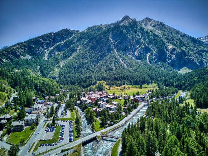
Cogne is the heart of the valley and a natural base for a few days of riding and hiking on the doorstep of Gran Paradiso National Park. The Lillaz waterfalls, a series of cascades on the Urtier torrent, are a short walk from the Lillaz parking area and well worth the stop after the climb.
On the way up, the route passes right by the Roman aqueduct-bridge of Pont d'Aël in the hamlet of the same name above Aymavilles. Built in 3 BC, it spans the Grand Eyvia gorge some 56 m above the river, and its covered lower walkway is open to visitors seasonally. Aymavilles itself is home to a castle with 12th-century origins.
Beyond the finish, the farm road continues up the Urtier valley past the ruins of the Crêt alp to the small Alpini chapel - an easy extension on a gravel bike or on foot. For the Aosta side of the valley, see our Pila climb. With the finish above 2,000 m, check current conditions before you go with our Weather tool.
ROUTE MAP
MEMBER RATING
CURRENT WEATHER
PJAMM TRIPS ADVENTURE STARTER BUNDLES
Check out PJAMM Adventure's prepackaged (self-guided) cycling trips. They will help you plan, document and conquer your next adventure.
NEARBY CLIMBS (0) RADIAL PROXIMITY
FROM No Climbs Found
MEMBER REVIEWS & COMMENTS
Let us know what you thought of this climb. Signup for our FREE membership to write a review or post a comment.
Already have an account?
LOG IN HERE
