THE BLOCKHAUS FROM LETTOMANOPELL
![]()
Submitted by, and much appreciation to,
Dave Parson, Stening, UK
There are three climbs to the Blockhaus, the easiest is from the east side via Fara Filiorum Petri, Pretoro, Passo Lanciano, Mammarosa and then to the end of the road. This climb starts nearer sea level, so if you are looking for the most elevation gain, this is the one to try. You could ride from the coast at Francavilla, dipping your toes in the water before you start, and then climb to the top 50 km and over 2000m later. The other two climbs are from the western side, one from Roccamorice and the other from Lettomanoppello. There is a very difficult road from Letto to Rocca; I’ve driven it once and thought at the time this could be the hardest road for cycling I have ever come across. From the driver’s seat of the car it felt tortuously steep and narrow and twisty. Maybe one day I’ll ride it.
![]()
The climb from Letto meets the easiest climb at Passo Lanciano and the two continue on to Mammarosa where they meet the Rocca climb. Therefore the Rocca climb is longer and climbs further before it meets the other two, logically it should be the toughest, but I want to try them both for myself to be sure. In the build up to the 2017 Giro I had read what others had said about the Rocca version of the climb, as it hasn’t featured in the Giro as much as the other versions. Dario Cataldo, a local professional, stated outright the Rocca version was the hardest.
![]()
On to the climb itself. The plan was to drive to the base of the climb, and ride up it fresh. In a few days time I’ll repeat the exercise from Rocca, and hopefully be able to compare the two climbs reasonably directly.
![]()
My base for this trip was on the eastern side, so just driving to Letto presented a few questions. The shortest drive would be up and over, but I thought it might be quicker to go around the mountain and only get onto the sinuous mountain roads as close to Letto as possible. My navigation skills let me down and I ended up driving a ridiculous combination of routes.
![]()
You can break the climb down into 4 parts –
- Letto to Passo. 10.9 km 9%
- Passo to Mammarosa. 4.8 km 6%
- Mammarosa to The Aerials 3.8 km 6%
- Aerials to shrine 5.1 km 7%
Letto is a nice little town, typically Italian. The sign on the edge of town, below, is just before the car park in the next picture.
![]()
In the picture below, the road to Roccamorice is off to the right, and the one up the mountain is on the left, a hairpin, and straight away you start to climb. Note the white estate car in this picture could be turning right up the road you can see, which leads to a small square. The climb up the hill is to his left, the other side of the pine tree in the photo.
![]() Letto is settled tight into the hill, making the first mile of the climb feel quite steep. The junction below comes 100-200m after a right turn, but both are signposted Passo Lanciano.
Letto is settled tight into the hill, making the first mile of the climb feel quite steep. The junction below comes 100-200m after a right turn, but both are signposted Passo Lanciano.
![]() Note the patchy road surface above; it doesn’t matter much when you are ascending (assuming like me you climb at about 6 mph!) but gets very rough coming back down. At speed you can’t spot the potholes and ridges so easily.
Note the patchy road surface above; it doesn’t matter much when you are ascending (assuming like me you climb at about 6 mph!) but gets very rough coming back down. At speed you can’t spot the potholes and ridges so easily.
![]() That’s Letto below with the Apennines in the background.
That’s Letto below with the Apennines in the background.
![]() This church comes just after a café of the same name, L’Iconicella, and is close to the end of the town.
This church comes just after a café of the same name, L’Iconicella, and is close to the end of the town.
![]() Looking south is Monte Amaro, which is the mountain the Blockhaus is part of. The summit is on the right, but this is for hikers only, I think the Blockhaus climb ends on the second peak on the left, but it could be the first.
Looking south is Monte Amaro, which is the mountain the Blockhaus is part of. The summit is on the right, but this is for hikers only, I think the Blockhaus climb ends on the second peak on the left, but it could be the first.
The Blockhaus itself was a fortification built around the time of the unification of Italy in the 1860’s. There isn’t much left of the building, just some crumbling walls, and it is about a 20 minute hike/scramble beyond the end of the road. Another thing on my to-do list!
![C:\Users\Helen\Pictures\Italy 2017\Blockhaus from Lettomanopello\IMG_5378.JPG]() A footpath off to the right of the road. Note the sign, showing use as a target, a popular pastime of mountain dwellers everywhere.
A footpath off to the right of the road. Note the sign, showing use as a target, a popular pastime of mountain dwellers everywhere.
![]() These signs are every 100m, this is 9.7 km from somewhere, possibly Manoppello as I was no more than 3 miles into the climb from here. It took me a while to figure out the numbers were increasing, my head was so full of the sights and sounds of the climb! A lot of these signs are faded so they don’t work very well.
These signs are every 100m, this is 9.7 km from somewhere, possibly Manoppello as I was no more than 3 miles into the climb from here. It took me a while to figure out the numbers were increasing, my head was so full of the sights and sounds of the climb! A lot of these signs are faded so they don’t work very well.
![]()
On the right is a shady picnic spot, where you can get water. The road switchbacks it’s way up this cliff a couple of times, before going straight for quite a distance, parallel and above gorge. Again, I was preoccupied with the climb and the views and wasn’t aware of how straight it was.
The guardrail/Armco seems to talk to you as it pops and clicks in the heat of the day. On top of that, there was a nasty swarm of flies that followed me for some distance; I just couldn’t ride fast enough to get away from them.
![]() The joys of 10 second self-timers! It doesn’t seem long when you have to clip back in, roll a little way down the hill, do a 180, and then try and look like a competent cyclist!
The joys of 10 second self-timers! It doesn’t seem long when you have to clip back in, roll a little way down the hill, do a 180, and then try and look like a competent cyclist!
![]()
![]() One for switchback lovers!
One for switchback lovers!
![]() Looking back down the mountain, in a roughly northerly direction.
Looking back down the mountain, in a roughly northerly direction.
![]() I missed this fella on the ride up the hill. Abruzzo has 3 national parks, home to bears and wolves. These are exotic creatures when you live in the south of England, although sadly I have never seen them in the wild.
I missed this fella on the ride up the hill. Abruzzo has 3 national parks, home to bears and wolves. These are exotic creatures when you live in the south of England, although sadly I have never seen them in the wild.
![]() I think this is a “Tholos” a stone shelter built by shepherds.
I think this is a “Tholos” a stone shelter built by shepherds.![]()
Back down the mountain, the road winding back down to Lettomanoppello.
![]() This guy passed me at the height of the fly attack. He must have seen me flapping my arms trying to swat them away, and he said “Le mosche!!” as he went by. He looked like Pig Pen with a cloud of the things buzzing all around him, I was sure they would be more obvious in this picture.
This guy passed me at the height of the fly attack. He must have seen me flapping my arms trying to swat them away, and he said “Le mosche!!” as he went by. He looked like Pig Pen with a cloud of the things buzzing all around him, I was sure they would be more obvious in this picture.
![]() Just before Passo Lanciano you enter a wooded section, with the switchbacks carrying on. You can just see 3 layers of the road in this shot.
Just before Passo Lanciano you enter a wooded section, with the switchbacks carrying on. You can just see 3 layers of the road in this shot.
![]() Someone’s shrine to their destroyed vehicle?
Someone’s shrine to their destroyed vehicle?
![]()
Out of the woods into the natural rest stop of Passo Lanciano. There’s another water fountain over by the trees and an Alpine-style café just beyond it. I filled my bottle and carried on.
![]() Back into the woods for a stretch after Passo. The heat was starting to build by now.
Back into the woods for a stretch after Passo. The heat was starting to build by now.
After Passo Lanciano, there are three more sections to the climb, all shorter than the first part up to Passo. The first section takes you to Mammarosa, a hotel and ski area, wooded part of the way; this is also where the road up from Roccamorice joins. Then there is the section to the aerials, at which point cars are supposed to stop, and the last part to the finish as the road gets really narrow and is starting to be reclaimed by the mountain.
![]() Straight ahead you can see the aerials, and to the right on the skyline is the hotel Mammarosa. The part from here to Mammarosa feels a little easier than what has gone before, but you need to recover as the last two parts are quite steep and you will be 90-120 minutes into the climb so starting to tire.
Straight ahead you can see the aerials, and to the right on the skyline is the hotel Mammarosa. The part from here to Mammarosa feels a little easier than what has gone before, but you need to recover as the last two parts are quite steep and you will be 90-120 minutes into the climb so starting to tire.
![]() Two bits of graffiti; they aren’t fans of Juventus in these parts.
Two bits of graffiti; they aren’t fans of Juventus in these parts.
![]()
![]() The long straight up to Mammarosa, there’s a couple of cafes here so you can stock up on food and drink if necessary.
The long straight up to Mammarosa, there’s a couple of cafes here so you can stock up on food and drink if necessary.
![]() Just after the hotel is this junction, and the ski businesses are concentrated here. The road goes down to Roccamorice; you can tell it was used in the Giro by the nice shiny smooth new Tarmac. Just over the brow is the peak of the Roccamorice climb, where the Giro organisers made us civvies dismount and get out of the way of their big finish. The pros came over the brow, swung right and went for another 200 m before ending the stage. Quintana was first over, looking more like he had just done a training ride than the hardest stage (so far). If you just want water there is a large stone trough again just over the brow of this hill, with constant running fresh water. Don’t take the stuff out of the trough though.
Just after the hotel is this junction, and the ski businesses are concentrated here. The road goes down to Roccamorice; you can tell it was used in the Giro by the nice shiny smooth new Tarmac. Just over the brow is the peak of the Roccamorice climb, where the Giro organisers made us civvies dismount and get out of the way of their big finish. The pros came over the brow, swung right and went for another 200 m before ending the stage. Quintana was first over, looking more like he had just done a training ride than the hardest stage (so far). If you just want water there is a large stone trough again just over the brow of this hill, with constant running fresh water. Don’t take the stuff out of the trough though.
![]() Next stop after Mammarosa are the Aerials, plenty of switchbacks to get here, and once here you will be free of cars.
Next stop after Mammarosa are the Aerials, plenty of switchbacks to get here, and once here you will be free of cars.
![]() The aerials are in two locations, once past the first, you get a glimpse to the south of the climb, and the road snaking away but you can sense the end is near.
The aerials are in two locations, once past the first, you get a glimpse to the south of the climb, and the road snaking away but you can sense the end is near.
![]()
The state of the road is now quite bad, partly I guess because vehicles are not meant to be here. As well as the holes and rocks, you need to be on your guard against Italian hikers who will almost certainly be on their phones. Maybe just one more gentle curve to the right before the end.
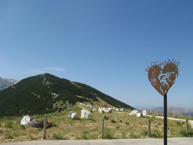
![]() The road ends with a turning circle and what I think is a new sign.
The road ends with a turning circle and what I think is a new sign.
![]() Would make a great finisher’s medal for a sportive!
Would make a great finisher’s medal for a sportive!
![]() This is a shrine complete with a Madonna and child. The gap in the bushes is a footpath which I believe goes to the remains of the Blockhaus, approx. 20 minutes hike away, although not in cycling shoes.
This is a shrine complete with a Madonna and child. The gap in the bushes is a footpath which I believe goes to the remains of the Blockhaus, approx. 20 minutes hike away, although not in cycling shoes.
![]() Looking east and slightly south, the Adriatic in the distance.
Looking east and slightly south, the Adriatic in the distance.
![]() Looking a bit tired here! Need to sharpen up for the descent…
Looking a bit tired here! Need to sharpen up for the descent…
![]() Not a road to take chances on! Thankfully there are guard rails for most of it, but the corners do need care; you can get caught out and offline because of potholes and loose gravel.
Not a road to take chances on! Thankfully there are guard rails for most of it, but the corners do need care; you can get caught out and offline because of potholes and loose gravel.
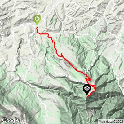
Here’s the Strava file - https://www.strava.com/activities/1140172799
44.9 km, moving time 3 hours 3 mins, ascent 1,931m. My bike is fitted with a 52/36 chainset and 11-32 cassette. I started fresh – hadn’t ridden for a week, but arguably in as good shape as I have ever been at least on the bike. I rode most if it seated in the 36/32 combo; I like to climb out of the saddle but it wasn’t necessary for a lot of the ride. I was pleased with my performance, apart from the heat I didn’t feel it was too much at any stage. The flies were hideous though, I would avoid August if you can.
The climb took 2 hours 48 at 8 km/h; the descent 34 mins at 38.5 km/h!