14.3
PDI
6 mi
DISTANCE
2,277 ft
GAINED
7.2 %
AVG. GRADE
FULL CLIMB STATS
INTRO
This 6 mile bike climb is located in Provence-Alpes-Côte d'Azur, France. The average gradient is 7.2% and there is a total elevation gain of 2,277 ft, finishing at 2,753 ft.
Use the profile tool, route map, and weather forecast to conquer this cycling climb.
Use the profile tool, route map, and weather forecast to conquer this cycling climb.
PLAN YOUR ROUTE
This climb averages 0%. The steepest quarter mile of this climb is 0%. NaN miles of the climb is at or above 10% grade. The gradient on this climb is broken down as follows:
See more details and tools regarding this climb's grade via our interactive Profile Tool.
See more details and tools regarding this climb's grade via our interactive Profile Tool.
Information Not Available
If you have any information regarding this climb, we'd like to hear from you. Click the CONTRIBUTE button to share your thoughts with us.
Information Not Available
If you have any information regarding this climb, we'd like to hear from you. Click the CONTRIBUTE button to share your thoughts with us.
Before heading out on any cycling adventure check out our Things to Bring on a Cycling Trip and use our interactive check list to ensure you don't forget anything.
Information Not Available
If you have any information regarding this climb, we'd like to hear from you. Click the CONTRIBUTE button to share your thoughts with us.
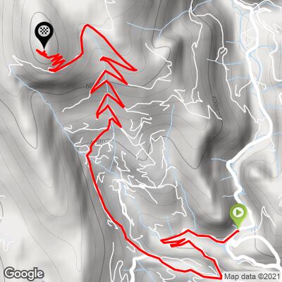
ROUTE MAP
MEMBER RATING
CURRENT WEATHER
PJAMM TRIPS ADVENTURE STARTER BUNDLES
Check out PJAMM Adventure's prepackaged (self-guided) cycling trips. They will help you plan, document and conquer your next adventure.
NEARBY CLIMBS (0) RADIAL PROXIMITY
FROM No Climbs Found
MEMBER REVIEWS & COMMENTS
Let us know what you thought of this climb. Signup for our FREE membership to write a review or post a comment.
Already have an account?
LOG IN HERE
MethowBiker
From centre ville Nice, this is a 20 mile out and back. It's a pump. Avoid roads with Roman names on the way out, as those are much steeper (15-18% for 1/3 mile) than the actual climb. This climb can be done all year. An advantage of it being close to the sea is that it is relatively warmer for its height. It's sheltered from the lively Var winds that make, say Aspremont (at 1500 feet lower) very chilly on a November day. Another advantage is the last mile is car free (not that there are many cars to begin with, if you see five in total that is busy). Go on a crisp fall day and you can see Corsica. Incredible views.