
17.5
PDI
8.7 mi
DISTANCE
2,978 ft
GAINED
6.4 %
AVG. GRADE
FULL CLIMB STATS
INTRO
PLAN YOUR ROUTE
 We've partnered with Sherpa-Map.com to bring you the best route planning tool. With a PRO Membership you can use this climb as a reference when creating your route.
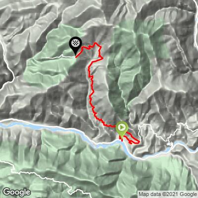
The Route de Thiéry averages 6.4% over 14.0 km (8.7 mi), but the climb has two very different halves.
Km 0-6: Irregular, gaining about 300 m (984 ft). The first three kilometers out of the valley run at 6.2-7.3%, then kilometers 4 and 6 drop to just 2.0% and 2.4% on the corniche section above the Var, with a 5.6% kilometer in between.
Km 6-14: The climb proper - about 595 m (1952 ft) of gain at 7.4%. Kilometers 7 and 8 both hold at 8.3-8.4%, there is a brief easing to 4.8% in kilometer 9, and then kilometers 10-12 build from 7.1% to 9.1%, the steepest full kilometer on the profile. The last two kilometers to the col run at 7.2% and 6.5%.
The steepest kilometer averages 10.5%, the steepest 5 km (3.1 mi) average 7.7%, and the steepest 100 m reach about 13.1%.
Roadway: Paved the entire way. This is a narrow mountain road - a lane and a bit in most places, with several narrow bridges and some cliff-side sections with a drop on the outside - so take the descent steadily. Visibility is generally good, with few truly blind bends. We found no reports of closures or roadworks on the route in 2026.
Traffic: Very light. The road dead-ends at Thiéry, a village with only a few dozen year-round residents, so nearly everything you meet is local. Riders consistently report seeing few or no cars on the whole climb. The D6202 along the Var valley at the start is a different story - it is the main road up the valley from Nice and is much busier, so keep your time on it short.
Parking: The climb starts right at the Villars-sur-Var stop on the Train des Pignes line from Nice, so you can arrive by rail and start pedaling immediately. There is no dedicated lot at the base, so drivers are better off looking for a spot in Villars-sur-Var, which the road passes about 2 km (1.2 mi) in, and rolling down to the start. At the top, Col de la Madone has a parking area beside the chapel, popular as a trailhead.
Provisions: Villars-sur-Var has a water point and is the last reliable stop on the way up. There is nothing on the climb itself, but Thiéry, 3 km (1.9 mi) past the col, has a water point and an auberge with a terrace café that is closed in winter.
Gear: The lower two-thirds are fairly well shaded, but the final stretch to the col is fully exposed, and this part of the Alpes-Maritimes gets very hot in July and August - riders have reported temperatures near 38 C (100 F) on the climb. Start early in summer and carry more water than you think you need. Grades never get extreme, so a standard compact crankset is plenty for most riders. The road is narrow on the way down, so make sure your brakes are in good shape.
Before heading out on any cycling adventure check out our Things to Bring on a Cycling Trip and use our interactive check list to ensure you don't forget anything.
Villars-sur-Var, the village at the bottom, is worth more than a pass-through. It is a medieval village stacked in levels on the hillside above the Var, with the ruins of a 15th-century Grimaldi castle and narrow vaulted lanes. It also has a wine story you would not expect this far into the mountains: the Clos Saint-Joseph estate makes Côtes de Provence wines here, and its vines are the only ones in the department with that appellation. A bottle from the cellar door makes a good souvenir of the ride.
Thiéry, 3 km (1.9 mi) past the col, sits on a rocky spine almost surrounded by deep valleys, with the Gorges du Cians to the west. Its church dates to the 11th century and has been restored to its 17th-century appearance - it is usually locked, but locals can point you to whoever holds the key. The GR510 hiking trail links Thiéry with Pierlas, which our Col de la Sinne (Pierlas) page covers in depth, and a roughly two-hour hiking trail climbs up to the village from the Train des Pignes stop at Touët-sur-Var by way of the Baisse de Thiéry.
This corner of the Alpes-Maritimes is packed with quiet climbs, from Massoins and Clans across the Var to the east to the Col de la Sinne above the Tinée. To see other climbs nearby, or build a custom route from here, try our Routes in the Area tool.
ROUTE MAP
MEMBER RATING
CURRENT WEATHER
PJAMM TRIPS ADVENTURE STARTER BUNDLES
Check out PJAMM Adventure's prepackaged (self-guided) cycling trips. They will help you plan, document and conquer your next adventure.
NEARBY CLIMBS (0) RADIAL PROXIMITY
FROM No Climbs Found
MEMBER REVIEWS & COMMENTS
Let us know what you thought of this climb. Signup for our FREE membership to write a review or post a comment.
Already have an account?
LOG IN HERE
