
18.3
PDI
7.3 mi
DISTANCE
2,818 ft
GAINED
7.3 %
AVG. GRADE
FULL CLIMB STATS
INTRO
Col de la Sinne from Pierlas climbs 11.8 km (7.3 mi) out of the Gorges du Cians to a 1437 m (4713 ft) col in the Alpes-Maritimes, gaining 859 m (2818 ft) at a 7.3% average. It turns off the D28 in a hairpin deep in the gorge, climbs a narrow, cliff-hugging road to the perched village of Pierlas, then pushes on over open high pastures to the col, which sits on the ridge between the Cians and the Tinée valley. It is currently ranked #1176 in the world in our database.
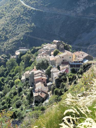
This is one of the least-known cols in the Nice hinterland, and that is the appeal. The lower road crosses a very narrow bridge over a side gorge and climbs a rock face in tight hairpins, with red pelite cliffs - the rock that gives the Cians its color - falling away below. The hardest stretch comes right after Pierlas, where an even narrower lane loops behind the village at 10-13%. After that the grade backs off, the views open out over the Tinée and the Mercantour peaks, and the last few kilometers feel remote in the best way. Riders regularly report meeting only a car or two on the whole climb.
The road faces south and has very little shade, so it gets hot in summer - this is a spring, early-summer or autumn ride if you can choose. The other side of the col comes up from the Tinée through Ilonse, and our Col de la Sine page covers that approach.
PLAN YOUR ROUTE
 We've partnered with Sherpa-Map.com to bring you the best route planning tool. With a PRO Membership you can use this climb as a reference when creating your route.
Col de la Sinne from Pierlas is 11.8 km (7.3 mi) long and gains 859 m (2818 ft) at a 7.3% average, from 581 m (1905 ft) in the Gorges du Cians to 1437 m (4713 ft) at the col. The steepest 1 km averages 11.9%, the steepest 0.5 km (0.3 mi) 12.3%, and the steepest 100 yards (91 m) touch 18.6%. The hardest 5 km (3.1 mi) average 8.7%.
The first 3 km (1.9 mi) are a gentle 4-7% warm-up, with an easier section around the 3 km mark. Then the road starts climbing the rock face in hairpins, and kilometers 4 and 5 average 9.5% and 10.2%. From there it settles to 7-8% up to Pierlas, at about 7 km (4.3 mi) and 1090 m (3576 ft).
The steepest kilometer of the climb comes immediately after the village: the lane behind Pierlas averages close to 11% with irregular pitches of 12-13%. Kilometer 10 eases to about 8%, kilometer 11 gives a real breather at around 3%, and the last kilometer kicks back up to about 7% to the col.
Roadway: The road is paved the entire way, but this is a narrow, single-track mountain road rather than a regular two-lane road. Up to Pierlas the D428 is well maintained, though it runs along a steep valley side with exposed drops and low verges, crosses a very narrow bridge over a side gorge, and climbs a rock face in tight hairpins. Just past Pierlas the road turns onto an even narrower lane that loops behind the village for about 1 km (0.6 mi); the asphalt there is rougher and patched. After renewal work, riders in 2019 described the asphalt above Pierlas as somewhat rough but free of potholes. Watch for gravel and fallen stones on the descent, and take the drops seriously.
Traffic: Very light. Rider reports describe meeting just one or two cars on the whole climb, mostly local traffic for Pierlas. The D28 through the Gorges du Cians below the turnoff is busier, since it is the main road up to Beuil and Valberg.
Parking: There is no village at the turnoff, which is a hairpin on the gorge road. The easiest base is the Var valley near Touët-sur-Var: the D28 leaves the N202 a couple of kilometers past Touët, and riding up the lower Gorges du Cians to the turnoff makes a scenic warm-up of about 8 km (5 mi). If you would rather start higher, Pierlas has a small car park just below the village, about 7 km (4.3 mi) into the climb.
Provisions: Pierlas is the only stop on the climb. The village has a vaulted fountain and a stone watering trough, and the Auberge Lou Poumié on the D428 serves local food (closed Mondays - check hours before counting on it). Above Pierlas there are no services, so leave the village with full bottles. The col has a picnic area but no café.
Gear: The road faces south and is in full sun for most of its length, so sun protection and plenty of water matter in summer. The 10-13% pitches around Pierlas reward low gearing - riders have used a 34 x 28 for this side. Flocks graze the high pastures above the village in summer, and livestock guardian dogs work with them, so slow down and give the herds room. On the descent, the narrow road and exposed drops call for a steady speed and good brakes.
Before heading out on any cycling adventure check out our Things to Bring on a Cycling Trip and use our interactive check list to ensure you don't forget anything.
Pierlas is the reason to ride this side. It is a tiny village of about 100 people, built in the 12th century on a steep rocky spur for defense and later a fief of the Grimaldi of Beuil. Its medieval Église Saint-Sylvestre, with a wall belfry and two bells, once belonged to the Knights Hospitaller of Saint John of Jerusalem, and the ruins of the older 12th-century Chapelle Saint-Sylvestre sit about 1.3 km (0.8 mi) east of the village, at the site of the original settlement. Old stone houses built partly into the rock, a covered fountain and a wash house make it worth a slow roll through.
The geology is the other draw. The Cians gorges are cut into red pelite, and a guided walk from Pierlas, Les Roches Rouges du Cians, covers why the site is considered exceptional geological heritage. The waymarked Sentiers Gourmands loop from the village climbs past the Granges de la Combette toward the col, a good rest-day leg-stretcher. The Auberge Lou Poumié has rooms and gîtes with views toward the Mercantour, and the village holds its festival in mid-July.
Ilonse, on the far side of the col, is covered on our Col de la Sine page, and the Col de la Couillole makes a classic loop with this climb. Because this side is so exposed, check current conditions with our Weather tool before you go.
ROUTE MAP

MEMBER RATING
CURRENT WEATHER
PJAMM TRIPS ADVENTURE STARTER BUNDLES
Check out PJAMM Adventure's prepackaged (self-guided) cycling trips. They will help you plan, document and conquer your next adventure.
NEARBY CLIMBS (0) RADIAL PROXIMITY
FROM No Climbs Found
MEMBER REVIEWS & COMMENTS
Let us know what you thought of this climb. Signup for our FREE membership to write a review or post a comment.
Already have an account?
LOG IN HERE
