Alba Road Bike Climb - PJAMM Cycling

16.9
PDI
3.8 mi
DISTANCE
2,047 ft
GAINED
10.3 %
AVG. GRADE

FULL CLIMB STATS

INTRO

"Alba Road is a very steep and scenic climb through stands of big redwoods along a variable grade. Variable in that it is either steep or steeper. The narrow road twists through a dark forest with a steeper first half and little traffic most days. The initial half mile is severe and with a few houses along the way a little bit of traffic although it is never heavy on this road. The grade then becomes variably steep as you continue through a tunnel of redwoods. The slope finally eases toward the very top and the ascent ends at Empire Grade with its access to other riding. Due to its steep grade it is a difficult and wild descent." (This quote is presented with the approval of John Summerson, from his book, The Complete Guide to Climbing (by Bike) in California, pg. 238.)
10.3% average grade with 0 descent.  39% of the climb is at 10-15% and 9% is at 15-20%. The steepest quarter-mile of the climb is a daunting 16.8%. 

See more details and tools regarding this climb's grade via the “Profile Tool” button.
Roadway:  Fairly good condition although a bit rough in spot.  There is likely to be some debris to watch for on the descent.

Traffic:  Minimal.

Parking:  Four spots on the right about a quarter-mile up the climb Street View, but there is really minimal opportunity to park on the first part of the route.  There may be spots available at the Ben Lomond Park near climb start - Map; Street View. 
Provisions:  There are several places to eat in Ben Lomond - Google Map - Places to Eat, as well as two markets - Google Map - Markets.
Before heading out on any cycling adventure check out our Things to Bring on a Cycling Trip and use our interactive check list to ensure you don't forget anything.
Alba Road is one of many nice climbs in the Santa Cruz Mountain area.  See PJAMM Climb Area Page - Santa Cruz County.

Staying in the area has several hotel options to choose from.  If you are staying in the area for a longer period of time a cottage or house rental may be a better choice. 

Use the “Routes in Area” button on the menu bar above to see other bike climbs in this area. 

ROUTE MAP

MEMBER RATING

Difficulty: Strenuous
4
Road
4.5
Traffic
2.5
Scenery

CURRENT WEATHER

PJAMM TRIPS ADVENTURE STARTER BUNDLES

Check out PJAMM Adventure's prepackaged (self-guided) cycling trips. They will help you plan, document and conquer your next adventure.
ALL TRIPS
Browse all of our prepackaged trips and find your next adventure!
San Francisco Bay Area
United States (CA)
25 ROUTES
30 POIs
ROUTE STATS (TOTAL)
487.9
mi
DISTANCE
65,482
ft
ELEV. GAIN

NEARBY CLIMBS (0) RADIAL PROXIMITY

FROM
No Climbs Found

MEMBER REVIEWS & COMMENTS

Let us know what you thought of this climb. Signup for our FREE membership to write a review or post a comment.
Already have an account?

May 16, 2024
difficulty: Strenuous
scenery: 3
traffic: 5
road: 5
May 16, 2024
scenery: 3
traffic: 5
road: 5
I have done this three times. It is a pretty tough climb, very unrelenting, the grade never really gets easier. There are no places to recover, just some 5-10% places sprinkled in between the monstrous 15% sections. It is shaded most of the time, when you start seeing the hills around you that's how you know you're close to the top.
Nov 1, 2022
difficulty: Strenuous
scenery: 2
traffic: 4
road: 3
Nov 1, 2022
scenery: 2
traffic: 4
road: 3
I ride Alba Rd. two or three times a week. It's tough, but it does give you rests in the form of less steep sections. It's almost like a stair case, but with false flats. The first mile is rough, then it relents a bit before hitting you with the steepest section. This is a road I survive now that I'm 52; I don't attack it. It flattens out a bit at the top where it rewards you with great views. On a clear day you can see Lick Observatory. The very end punished you again with a stepped stair case that gets harder. Other climbs in the area are Jamieson Creek Rd., China Grade, Felton Empire Grade (a LOT of traffic on this one, I only go down this now), Empire Grade, East Zayante Rd. to Summit, and Mt. Charlie Rd. Alba Rd. is the most difficult, but linking climbs is a good way to get 10k feet in on one day.
ROUTE MAP
PROFILE TOOL
Route Data
S.G. (%)
hide
Segment Data
hide
CLIMB SUMMARY

Bicycle climb of Alba Road in the  Santa Cruz Mountains, Pacific Coast Range.

Cycling Alba Road

Ride 3.8 miles gaining 2,040’ at 10.3% average grade.

A Bay Area Top 10 Most Scenic Bike Ride

​Climb summary by PJAMM’s John Johnson.

The Beast of the West!  This one is #3 on the Top Santa Cruz/Santa Clara Climbing List. This is the toughest climb in Santa Cruz County and the Santa Cruz Mountains.  From the start it sinks its teeth into us and does not let go until we approach the stop sign at the intersection of Alba Road and Empire Grade, 3.8 brutal miles later.  We love this climb as we are surrounded by and covered in redwoods nearly the entire climb.  Plus, due to the very low traffic along the roadway, this is a very peaceful, although tortuous climb.

Cycling Alba Road - riding through redwoods; alba schoolhouse

A tranquil, though painful, ride through the Santa Cruz Mountains and redwood forest.


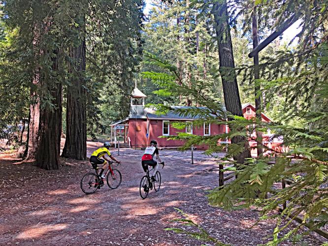
There is a very cool restored one-room type schoolhouse a mile or so up the climb called the Alba Schoolhouse.  Be sure to stop and take a look around.

Alba School house; cyclists

We also start (and finish if you are doing an up and downer) at the northern edge of Ben Lomond, a fairly sizeable Santa Cruz Mountain town with several dining and lodging options to choose from.  

Before heading out to cycle Alba Road, be sure to rely on our list of Things to Bring on a Cycling Trip, and use our interactive checklist to ensure you don't forget anything.

Roadway Surface and Traffic Report:  The road varies from double to single lane and is in fair condition.  There is minimal traffic along the route and we rate this as a very safe climb.