
16.7
PDI
13.7 mi
DISTANCE
3,433 ft
GAINED
4.7 %
AVG. GRADE
FULL CLIMB STATS
INTRO
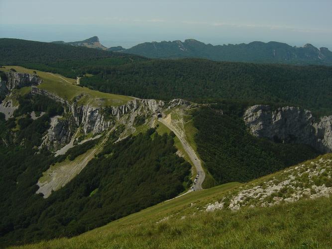
On this side you don't see the Col de la Bataille until you're nearly on it: a dark tunnel mouth in the limestone at the end of a long, gentle road up from the Royans. Ride through it and the view opens on the far side, straight down over the Bouvante valley and the western edge of the Vercors.
From Oriol-en-Royans it's 22.0 km (13.7 mi) to the tunnel at 1329 m (4,359 ft), gaining 1046 m (3,433 ft) at 4.7% - long, but rarely hard. The first 8 km roll up the Léoncel road at a steady 5%, there's a stiffer stretch around km 9, and then the road almost flattens across Val-Fanjouse before climbing again past the hamlet of La Charge. The last real work comes on the D199 above Le Grand Échaillon, at 5 to 6%, and the final 2 km to the tunnel are close to flat.
It's a quiet ride, with long views over the Lyonne valley on the way up and nothing to buy once you've left the valley. Pick a calm day - the col has a reputation for wind - and it has a fair claim to the best finish in the Vercors.
PLAN YOUR ROUTE
 We've partnered with Sherpa-Map.com to bring you the best route planning tool. With a PRO Membership you can use this climb as a reference when creating your route.
The climb averages 4.7% over 22.0 km (13.7 mi), from 290 m (952 ft) in Oriol-en-Royans to 1329 m (4,359 ft) at the tunnel, which sits just above the 1313 m (4,308 ft) col.
The first 8 km are remarkably even, every kilometer between 4.5% and 5.3%. Kilometers 9 and 10 are the steepest pair at 6.0% and 5.7%, and the steepest kilometer (8.7%) and steepest 500 m (10.6%) both fall around km 8 to 9. The steepest 2 km average 7.6%.
From km 10 to km 13 the road eases to 2.8-3.5% across Val-Fanjouse, then picks up past La Charge (4.8%, 6.7% and 4.7%) and on the D199 above Le Grand Échaillon (4.5%, 6.3%, 5.8% and 5.0%). The steepest 5 km average 5.9% and the steepest 10 km 5.2%. The final 2 km to the tunnel drop to 3.2% and 2.0%.
Roadway: Paved throughout, and riders describe the surface as good, though one warns of gravel on the descent - don't let the easy gradients lull you on the way down. The D199 over the col is seasonal: the Drôme department closes a section of it at the col from 4 November 2026 for the winter, while the road up from Léoncel to the col stays open until frost and snow arrive. Check the Vercors Drôme tourist office's road-info page before a spring or autumn ride.
Traffic: Light. Below La Charge it's mostly local traffic heading up to the plateau, and above Le Grand Échaillon you'll mainly meet people driving up to the col and its viewpoints on fine weekends. Watch for cars coming through the tunnel at the top.
Parking: The climb starts on the Léoncel road at the southern edge of Oriol-en-Royans, a few minutes' ride from Saint-Jean-en-Royans, which has the shops and more room to park - our Col de la Bataille (Bouvante) page starts from the same spot. If a car is meeting you at the top, note that the recent viewpoint works at the col replaced the old roadside parking with a footpath, so expect a short walk.
Provisions: Stock up in Saint-Jean-en-Royans and leave with two full bottles - there's nowhere reliable to refill on the climb, and the lower slopes can be hot in summer. The Auberge de Léoncel, a cooperative café-restaurant about 1 km (0.6 mi) off the route in Léoncel, does lunch and snacks, but only on certain days: weekends in late autumn, closed January to March, and every day except Tuesday and Wednesday in high summer.
Gear: Only a short stretch around km 9 goes past 8%, so standard compact gearing is plenty. What you do want is a windproof layer - the finish is exposed at over 1300 m and the col is known for wind - and a rear light for the tunnel.
Before heading out on any cycling adventure check out our Things to Bring on a Cycling Trip and use our interactive check list to ensure you don't forget anything.
Léoncel is worth the 1 km detour off the route. Its abbey church was built by Cistercian monks in the 12th century, with a Romanesque choir and a Gothic nave; there's been no monastic community since the Revolution, but a hermit still sings the daily offices there, and Mass is said every day in summer.
At the top, the department's recent work on the D199 added a cantilevered viewpoint at the col with a stone ring sculpture, the Anneau de Pierre by Christophe Gonnet, plus more lookouts along the road beyond at Les Lames, L'Arche and the Pas de l'Aubasse. Our Col de la Bataille (Bouvante) page covers that road down toward Bouvante, the Forêt de Lente and the autumn bird migration over the col.
For a bigger day, the Col de Tourniol and the Col des Limouches also start from the Saint-Jean-en-Royans area, and riders often link the Bataille with the Col de la Machine and the Combe Laval road. The Routes in the Area map on this page shows how they connect.
ROUTE MAP

MEMBER RATING
CURRENT WEATHER
PJAMM TRIPS ADVENTURE STARTER BUNDLES
Check out PJAMM Adventure's prepackaged (self-guided) cycling trips. They will help you plan, document and conquer your next adventure.
NEARBY CLIMBS (0) RADIAL PROXIMITY
FROM No Climbs Found
MEMBER REVIEWS & COMMENTS
Let us know what you thought of this climb. Signup for our FREE membership to write a review or post a comment.
Already have an account?
LOG IN HERE
