
24.9
PDI
11 mi
DISTANCE
3,998 ft
GAINED
6.9 %
AVG. GRADE
FULL CLIMB STATS
INTRO
PLAN YOUR ROUTE
 We've partnered with Sherpa-Map.com to bring you the best route planning tool. With a PRO Membership you can use this climb as a reference when creating your route.
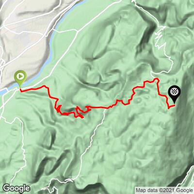
 Col du Mont Noir gains 1,219 m (3,998 ft) over 17.7 km (11.0 mi) at a 6.9% average grade - a number that undersells how irregular the climb actually feels. Rider reports and our data agree the steepest stretch is the three kilometers approaching Le Faz (around km 7-10), averaging 9-10%, and the steepest single kilometer on the route hits 9.7%.
After Le Faz, the grade eases into a long, rolling middle section through the Coulmes forest before the final kilometer to the col, which is noticeably easier than what comes before it. Pace the early forested kilometers conservatively - this climb punishes going out too hard before Le Faz.
Roadway: Paved the entire way, though surface quality is inconsistent - generally good through Saint-Pierre-de-Chérennes and the lower forested kilometers, but patchier and rougher in the upper Coulmes forest section, where riders consistently note mediocre pavement. Wider, more resistant tires are worth having. The road is open seasonally, typically April 1 through October 31; the section beyond Carrefour de Patente closes in winter to make way for the Coulmes Nordic ski area, subject to snow conditions.
Traffic: Light. This is a long, quiet forest road with little through-traffic compared to the busier Écouges approach on the mountain's other side - most who ride it are doing so deliberately rather than passing through.
Parking: Saint-Pierre-de-Chérennes has parking near the village center at the base of the climb. Beauvoir-en-Royans, about 2.5 km before the village on the D31, is a common alternate start if you'd rather extend the ride slightly.
Bring wider, more puncture-resistant tires than you might for a well-paved Alpine climb - the upper forested section has patchy, sometimes broken pavement. A wide-range cassette or compact crankset helps on the sustained 9-10% stretch approaching Le Faz. There are no services above Saint-Pierre-de-Chérennes for most of the climb, so carry your own water and food.
Before heading out on any cycling adventure check out our Things to Bring on a Cycling Trip and use our interactive check list to ensure you don't forget anything.
Saint-Pierre-de-Chérennes is a small village in the Isère, a short drive from Pont-en-Royans, well known for its colorful houses built directly over the Bourne river gorge - worth a stop if you have time before or after the ride.
Once at the col, riders looking for a loop rather than an out-and-back have several descent options: back the way you came, down through the Gorges des Écouges toward Saint-Gervais (see our Col du Mont Noir (Saint-Gervais) page for that side), or via Rencurel and the Gorges de la Bourne. Whichever way down, expect patchy pavement in places and descend with some caution.
See other climbs around the Vercors and Isère with our Routes in the Area tool if you're building out a multi-day trip in the massif.
ROUTE MAP
MEMBER RATING
CURRENT WEATHER
PJAMM TRIPS ADVENTURE STARTER BUNDLES
Check out PJAMM Adventure's prepackaged (self-guided) cycling trips. They will help you plan, document and conquer your next adventure.
NEARBY CLIMBS (0) RADIAL PROXIMITY
FROM No Climbs Found
MEMBER REVIEWS & COMMENTS
Let us know what you thought of this climb. Signup for our FREE membership to write a review or post a comment.
Already have an account?
LOG IN HERE
