
25.4
PDI
10.8 mi
DISTANCE
4,005 ft
GAINED
7.1 %
AVG. GRADE
FULL CLIMB STATS
INTRO
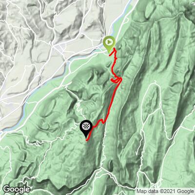
Col du Mont Noir climbs 17.3 km (10.8 mi) from the village of Saint-Gervais in Isère, gaining 1221 m (4,005 ft) at a 7.1% average grade to reach 1422 m (4,664 ft) - the highest point any paved road reaches in the Vercors massif.
It's rated Hors Catégorie, and with good reason: outside of a brief false-flat past the halfway point, the road rarely lets up.
The lower two-thirds follow the D35 through the Gorges des Écouges, a narrow limestone canyon where the road runs directly beneath towering cliff walls and past the Cascade des Écouges, a waterfall that drops right alongside the pavement. A lit but narrow tunnel carries the road through the gorge's tightest point - a detour forced by the permanent closure of the old cliffside corniche route years ago.
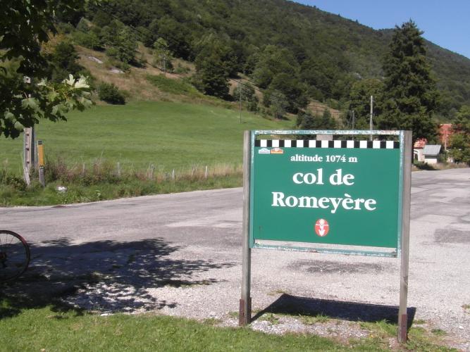
Past the tunnel, the road eases through a long, gentle stretch before reaching the Col de Romeyère at 1,074 m, where the route turns off onto a narrower forest lane for the final push to the Mont Noir summit.
That final stretch runs about 5 km through the dense forest of the Coulmes, holding a steady 7% with a rougher, sometimes patchy road surface that can be worse right after winter.
Col du Mont Noir was part of Stage 4 of the 2018 Critérium du Dauphiné, crossed with Dario Cataldo leading over the top before the race continued on to Lans-en-Vercors.
PLAN YOUR ROUTE
 We've partnered with Sherpa-Map.com to bring you the best route planning tool. With a PRO Membership you can use this climb as a reference when creating your route.
 Col du Mont Noir averages 7.1% over 17.3 km (10.8 mi), but the grade is far from constant. The steepest 100 yards reaches 18.0%, and the steepest full mile still averages 10.0% - both concentrated in the lower half, on the tougher pitches approaching the Écouges tunnel.
The climb runs in two distinct halves: From Saint-Gervais to the Cascade des Écouges, the gradient holds a fairly even 7-8%, with a brief, welcome flat spot right at the waterfall. The steepest sustained pitches come in the kilometer or so before the tunnel; after it, the road relaxes into a long, gently graded stretch through the gorge and on to the Col de Romeyère. From there, the final 5 km to the Mont Noir summit holds a steady 7% through forest, with no more flat ground until the top.
Roadway: The D35 is paved the entire way from Saint-Gervais to the Col de Romeyère, including through the roughly 500 m Écouges tunnel, which is narrow but now lit - a bike light is still worth carrying as a backup. Past Col de Romeyère, the final 5 km or so to Col du Mont Noir runs on a narrower forest road that can be noticeably rougher, especially just after winter; riders have reported it freshly resurfaced in places and patchy or broken in others depending on the year. The Gorges des Écouges section has a history of rockfall-related closures for cliff safety work, so check Isère's Inforoute38 road status before an off-season attempt.
Traffic: Light overall, and lightest of all past Col de Romeyère, where the forest road carries little through-traffic since it doesn't lead anywhere beyond Rencurel and the Mont Noir descent toward Cognin-les-Gorges. The lower gorge section sees more cars, since it's the main route between Saint-Gervais and Rencurel, but drivers there are used to sharing the road with cyclists.
Parking: Free street parking is available in Saint-Gervais near the village center, right where the D35 begins climbing out of town.
This is a Hors Catégorie climb by any measure - 1,221 m (4,005 ft) of gain that takes most cyclists close to two hours - so gear accordingly. A compact crank (34-tooth small ring) paired with a wide-range cassette (30-34 teeth) is the standard local recommendation, and it's not excessive given the sustained 7-8% pitches and the steeper ramps near the tunnel.
Bring a front light for the Écouges tunnel - it's lit now, but the tunnel is narrow, slightly curved, and shared with cars, so extra visibility is worth the minor extra weight.
There's nowhere to reliably refill water between Saint-Gervais and the summit, so carry what you need for the full climb; the waterfall partway up makes a natural, scenic place to pause.
Check your bike over before you go - the forest-road section past Col de Romeyère can have broken pavement or gravel patches depending on recent maintenance, and there are no bike shops along the route itself.
Before heading out on any cycling adventure check out our Things to Bring on a Cycling Trip and use our interactive check list to ensure you don't forget anything.
Saint-Gervais is a small village of around 540 people at the foot of the Vercors, about 20 km southwest of Grenoble - a quiet, practical base rather than a resort town, with Grenoble's full range of restaurants, bike shops, and hotels a short drive away if you want more options.
The Gorges des Écouges the climb runs through are a destination in their own right, popular with canyoning groups heading for the waterfall's rappel, so don't be surprised to see wetsuited canyoners near the base of the falls on a summer weekend.
The descent toward Cognin-les-Gorges on the climb's other side, through the Gorges du Nan, is well regarded as one of the most scenic roads in the Vercors and worth building into a loop if you have a way to shuttle back.
Ride between late spring and early fall - snow and ice can linger on the shaded final kilometers into the Coulmes forest well into spring, and the D35 through the gorge has a history of closures for rockfall mitigation work, so check current conditions before a visit. See other climbs around the Vercors and Isère with our Routes in the Area tool.
ROUTE MAP
MEMBER RATING
CURRENT WEATHER
PJAMM TRIPS ADVENTURE STARTER BUNDLES
Check out PJAMM Adventure's prepackaged (self-guided) cycling trips. They will help you plan, document and conquer your next adventure.
NEARBY CLIMBS (0) RADIAL PROXIMITY
FROM No Climbs Found
MEMBER REVIEWS & COMMENTS
Let us know what you thought of this climb. Signup for our FREE membership to write a review or post a comment.
Already have an account?
LOG IN HERE
