21.6
PDI
8 mi
DISTANCE
3,220 ft
GAINED
7.4 %
AVG. GRADE
FULL CLIMB STATS
INTRO
This 8 mile bike climb is located in Auvergne-Rhône-Alpes, France. The average gradient is 7.4% and there is a total elevation gain of 3,220 ft, finishing at 5,517 ft.
Use the profile tool, route map, and weather forecast to conquer this cycling climb.
Use the profile tool, route map, and weather forecast to conquer this cycling climb.
PLAN YOUR ROUTE
This climb averages 0%. The steepest quarter mile of this climb is 0%. NaN miles of the climb is at or above 10% grade. The gradient on this climb is broken down as follows:
See more details and tools regarding this climb's grade via our interactive Profile Tool.
See more details and tools regarding this climb's grade via our interactive Profile Tool.
Information Not Available
If you have any information regarding this climb, we'd like to hear from you. Click the CONTRIBUTE button to share your thoughts with us.
Information Not Available
If you have any information regarding this climb, we'd like to hear from you. Click the CONTRIBUTE button to share your thoughts with us.
Before heading out on any cycling adventure check out our Things to Bring on a Cycling Trip and use our interactive check list to ensure you don't forget anything.
Information Not Available
If you have any information regarding this climb, we'd like to hear from you. Click the CONTRIBUTE button to share your thoughts with us.
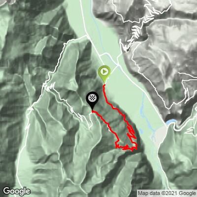
ROUTE MAP
MEMBER RATING
CURRENT WEATHER
PJAMM TRIPS ADVENTURE STARTER BUNDLES
Check out PJAMM Adventure's prepackaged (self-guided) cycling trips. They will help you plan, document and conquer your next adventure.
NEARBY CLIMBS (0) RADIAL PROXIMITY
FROM No Climbs Found
MEMBER REVIEWS & COMMENTS
Let us know what you thought of this climb. Signup for our FREE membership to write a review or post a comment.
Already have an account?
LOG IN HERE
golmstead
Really one of my favorite rides ever. Just amazing. The road starts out winding though the forest but gets to the 3km long balcony road soon enough. The road is carved out of solid rock and as you look to your left you can see Alpe d'Huez and a little bit of Col du Galibier. There are four tunnels early on, and only one requires a light to get through it. Fortunately for me, the rider ahead of me took out his phone/flashlight to lead us through the tunnel. The road transitions back to forest for some switchbacks, then there's some gravel road for a bit at the summit. Lots of technical descending takes you back to the start. The great thing about the ride is that you see one vista one the way up, another at the summit, and a third on the descent. An unforgettable ride for sure.