
31.1
PDI
10.8 mi
DISTANCE
4,471 ft
GAINED
7.9 %
AVG. GRADE
FULL CLIMB STATS
INTRO
Chamrousse (Séchilienne) is a 10.8-mile climb in the Belledonne range above Grenoble, in France's Isère department. It gains 4,471 feet at an average grade of 7.9%, climbing from Séchilienne at 1,365 feet up through the forest to the Chamrousse ski resort at 5,836 feet.
The climb splits cleanly into two halves. The first 9 kilometers out of Séchilienne run up a narrow, patchy communal road through dense forest, holding a relentless 9-10% grade with ramps into the mid-teens - the steepest quarter mile reaches 19.0%. After a brief respite at the Col du Luitel, home to the Réserve Naturelle du Lac Luitel (one of France's oldest nature reserves, protecting a rare high-altitude peat bog), the road widens onto the D111 for the final miles into Chamrousse, easing to a far more manageable 5-7% the rest of the way. That split character is what makes this a genuinely tough way up the mountain - the lower Luitel section is regularly compared to a smaller Col de la Croix de Fer.
This is also one of several climbs converging on Séchilienne and the surrounding Belledonne valleys, including Col de la Morte, so our Routes in the Area tool is worth a look if you want to string together more than one climb from the same base.
PLAN YOUR ROUTE
 We've partnered with Sherpa-Map.com to bring you the best route planning tool. With a PRO Membership you can use this climb as a reference when creating your route.
 Chamrousse (Séchilienne) averages 7.9% over 10.8 miles, gaining 4,471 feet from 1,365 feet in Séchilienne to 5,836 feet at the Chamrousse resort. The steepest 100 yards reaches 20.4%, the steepest quarter mile averages 19.0%, and the steepest half mile averages 17.7%. Sustained over a full mile, the steepest stretch is 15.3%, and over 2.5 miles it settles to 11.8%.
Nearly all of the hardest climbing comes in the lower half, on the forested run up to the Col du Luitel - the final miles into the Chamrousse resort ease off considerably.
Roadway: Two distinct surfaces on this climb. The first 9 kilometers out of Séchilienne, up to the Col du Luitel, run on a narrow communal road that's bumpy and patchy in places - go easy if you're descending this way. From the Col du Luitel to the Chamrousse resort the road widens onto the D111 and the pavement improves noticeably. The Luitel high point sits above 4,100 feet and can hold snow or ice into spring, so check conditions before an early or late-season ride.
Traffic: Light for almost the entire climb. The lower Séchilienne-to-Luitel section sees very little traffic of any kind. It picks up modestly on the wider D111 above the col, especially near the Chamrousse resort itself, but it's nothing like a major alpine pass.
Parking: Séchilienne is a small village on the D1091 between Vizille and Le Bourg-d'Oisans. The town hall parking (parking de la mairie) in the village center is the most practical place to leave a car before starting the climb.
There's nothing in the way of shops or water on the lower forested section, so fill up in Séchilienne before you start. The Chamrousse resort at the top has cafes, restaurants, and shops to refuel at before the descent, though hours can be limited outside the winter ski season and summer hiking season.
Before heading out on any cycling adventure check out our Things to Bring on a Cycling Trip and use our interactive check list to ensure you don't forget anything.
Séchilienne sits on the D1091 between Vizille and Le Bourg-d'Oisans, about 20 minutes from Grenoble, making it an easy base if you're riding several of the climbs in the Belledonne range - Col de la Morte and the Route du Poursollet both start from the same general area.
About a third of the way up, the road passes the Réserve Naturelle du Lac Luitel, one of France's oldest nature reserves (established 1961), protecting a rare high-altitude peat bog - worth a short stop if you have the legs to spare.
Chamrousse itself is a full four-season resort at the top, so there's a real option to spend the night and ride back down fresh the next morning rather than descending tired.
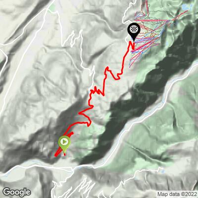
ROUTE MAP
MEMBER RATING
CURRENT WEATHER
PJAMM TRIPS ADVENTURE STARTER BUNDLES
Check out PJAMM Adventure's prepackaged (self-guided) cycling trips. They will help you plan, document and conquer your next adventure.
NEARBY CLIMBS (0) RADIAL PROXIMITY
FROM No Climbs Found
MEMBER REVIEWS & COMMENTS
Let us know what you thought of this climb. Signup for our FREE membership to write a review or post a comment.
Already have an account?
LOG IN HERE
