
20.2
PDI
9.3 mi
DISTANCE
3,295 ft
GAINED
6.7 %
AVG. GRADE
FULL CLIMB STATS
INTRO
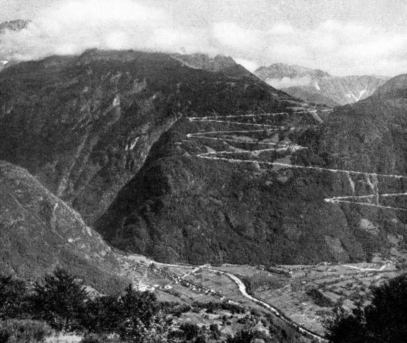
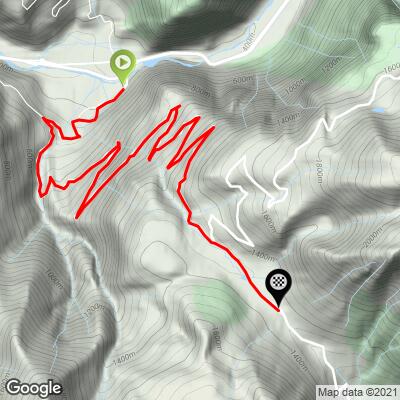
The Col de la Morte climbs from the Romanche valley floor at Séchilienne (368 m/1,208 ft) up to the high plateau village of La Morte, home of the Alpe du Grand Serre resort, at roughly 1,370 m (4,500 ft). It covers 15.0 km (9.3 mi) and 1,004 m (3,295 ft) of climbing at a 6.7% average, passing through Saint-Barthélemy-de-Séchilienne on the way.
What sets this climb apart is how even it is. The grade barely strays from the 7-8% range once it gets going, with a few easier sections early on near Saint-Barthélemy and a harder stretch after the turn toward the Laffrey lakes. Almost the whole ride is in forest, so it is shaded and pleasantly cool in summer, but views are scarce until the trees open near the top. Traffic is light, and the ride ends with a gentle final kilometer through the resort.
The road dates to 1938, the same year the La Morte ski station was founded, and the climb is a classic of the Grenoble area's Taillefer foothills. It shares its first 15 km with our Col de la Morte + Route du Poursollet climb if you want to keep going above the col.
PLAN YOUR ROUTE
 We've partnered with Sherpa-Map.com to bring you the best route planning tool. With a PRO Membership you can use this climb as a reference when creating your route.
Average grade is 6.7% over 15.0 km (9.3 mi), with no descents. The steepest quarter mile (0.4 km) is 8.8%, the steepest 500 meters is 8.6%, the steepest kilometer is 8.1%, and the steepest continuous mile (1.6 km) is 8.0%. Even the steepest 100 yards (91 m) tops out at 9.2%, so there are no walls here.
The grade is remarkably consistent: the steepest 2 km average 7.9%, the steepest 5 km 7.5%, and the steepest 10 km 7.4%. That makes it a good climb to settle into a steady pace.
Roadway: The route is paved from Séchilienne to the resort village of La Morte, and the surface on the Séchilienne side is generally good. The far side of the col, descending toward Le Villard, is rougher, with loose gravel reported in places, so it is best to return the way you came unless you know the road. At about 1,370 m the upper road can hold snow in winter and early spring - check conditions before an early or late-season ride.
Traffic: Traffic is light on the climb itself, especially outside the ski season. The busy road is the main valley highway through Séchilienne between Grenoble and Le Bourg-d'Oisans, so the quiet begins as soon as you turn up toward Saint-Barthélemy.
Parking: Séchilienne has parking in the village center near the mairie (town hall). If you would rather start from the top, Alpe du Grand Serre has a free car park in the resort village, which suits a ride around the Boucle des lacs or out toward the Route du Poursollet.
Provisions: There are no services along the climb, so fill bottles and eat in Séchilienne before you start. Don't count on anything being open in the resort village at the top, since its operations have been uncertain in recent years.
Gear: The forest keeps you in shade for most of the ride, and the top is roughly 1,000 m (3,300 ft) higher than the start, so pack a light jacket for the descent, plus a spare tube and pump since there is nowhere to get help along the way.
Before heading out on any cycling adventure check out our Things to Bring on a Cycling Trip and use our interactive check list to ensure you don't forget anything.
La Morte is the natural extension of this ride. The resort village of Alpe du Grand Serre sits at about 1,368 m (4,488 ft) under the Taillefer massif, with hiking trails around the Grand Serre peak. From the top you can drop to the Matheysine plateau, or follow the 51 km Boucle des lacs, which the Matheysine tourism office lists as open from 1 April to 30 November. The loop links the Col de la Morte with the lakes of Laffrey, and it can be ridden in either direction. The Laffrey ramp on the return is a steep, fast descent, so keep your speed in check.
At Laffrey, the Prairie de la Rencontre marks the spot where Napoleon, returning from Elba, met the Royalist army on 7 March 1815; an equestrian statue of the Emperor overlooks the lake, and the site has parking, toilets and a picnic area. Beyond the col, our Col de Malissol pages continue the area's quiet climbs. For other Séchilienne climbs, see our Col du Luitel and Chamrousse pages, which cover the village and the Luitel nature reserve in detail.
To see other climbs nearby and build a longer route from here, try our Routes in the Area tool.
ROUTE MAP
MEMBER RATING
CURRENT WEATHER
PJAMM TRIPS ADVENTURE STARTER BUNDLES
Check out PJAMM Adventure's prepackaged (self-guided) cycling trips. They will help you plan, document and conquer your next adventure.
NEARBY CLIMBS (0) RADIAL PROXIMITY
FROM No Climbs Found
MEMBER REVIEWS & COMMENTS
Let us know what you thought of this climb. Signup for our FREE membership to write a review or post a comment.
Already have an account?
LOG IN HERE
