
29.6
PDI
11.5 mi
DISTANCE
4,456 ft
GAINED
7.4 %
AVG. GRADE
FULL CLIMB STATS
INTRO
PLAN YOUR ROUTE
 We've partnered with Sherpa-Map.com to bring you the best route planning tool. With a PRO Membership you can use this climb as a reference when creating your route.
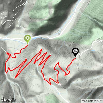
 This combined climb averages 7.4% over 18.5 km (11.5 mi) and 1,358 m (4,456 ft) of gain, but the grade is not evenly distributed. The steepest 100 yards reaches 18.8%, and even sustained over a full kilometer, the steepest section still holds 11.6% - short, sharp ramps concentrated in the lower-to-middle portion, on the way to the Col de la Morte. Widen the window and the numbers ease steadily: the steepest quarter mile averages 15.2%, the steepest full mile 10.2%, and the steepest 5 km stretch settles to 8.4%. In practice, the climb to Col de la Morte itself is the more irregular, punchy section, while the continuation onto the Route du Poursollet toward its high point rolls at a steadier, more moderate grade.
Roadway: The road is paved the entire way from Séchilienne to the high point of the Route du Poursollet, and is generally described as being in good, well-maintained condition - narrow in places but a real road throughout, not a track. The Route du Poursollet section beyond the ski station is quieter and less frequently used than the main Col de la Morte road, and like most high routes in this part of the French Alps, the upper stretch is a seasonal road that can hold snow well into spring - check conditions before planning a ride outside the late-spring-to-autumn window.
Traffic: Traffic is light on both sections - this isn't a through-route to anywhere, so most vehicles on the road are headed to the same places you are (the ski station, the lake, or a handful of homes and farms). The Col de la Morte side sees a bit more use than the Route du Poursollet continuation, which is largely the preserve of cyclists, hikers, and locals.
Parking: Roadside parking is available in Séchilienne at the base of the climb, in the Romanche valley. Riders can also start partway up, near the La Morte ski station past the Col de la Morte, if they only want to tackle the Route du Poursollet continuation on its own.
Séchilienne has the last shops and cafes before the climb begins; there's little to nothing in the way of services on the mountain itself until the La Morte ski station past the Col de la Morte, and even that's seasonal and limited. Carry what you need for the full ride, especially on the quieter Route du Poursollet continuation.
A compact crank and a wide-range cassette (30-32 teeth or larger in back) are worth having for the steep, irregular pitches on the way to Col de la Morte, where ramps well into the teens follow long, shaded, steady sections. Temperatures at 1,726 m can be noticeably cooler than in the Romanche valley below, so pack a light layer for the descent.
Before heading out on any cycling adventure check out our Things to Bring on a Cycling Trip and use our interactive check list to ensure you don't forget anything.
Séchilienne is a small Romanche valley village about 20 minutes southeast of Grenoble, with easy access from the city and modest services of its own. Grenoble itself, with a full range of lodging, restaurants, and rail connections, makes a practical base for tackling this climb alongside other well-known ascents in the surrounding Belledonne, Taillefer, and Oisans ranges.
Beyond the Col de la Morte, the quieter Route du Poursollet climbs through forest toward a high plateau near Lac du Poursollet, with views opening toward the Taillefer massif and, in clear conditions, the Oisans massif in the distance - a genuinely different, more solitary character than the busier Col de la Morte road below it.
Note that this climb shares its first 15 km with the standalone Col de la Morte (Séchilienne) climb from the same Séchilienne start; riders who've already done that climb will recognize the lower two-thirds before the Route du Poursollet extension begins.
ROUTE MAP
MEMBER RATING
CURRENT WEATHER
PJAMM TRIPS ADVENTURE STARTER BUNDLES
Check out PJAMM Adventure's prepackaged (self-guided) cycling trips. They will help you plan, document and conquer your next adventure.
NEARBY CLIMBS (0) RADIAL PROXIMITY
FROM No Climbs Found
MEMBER REVIEWS & COMMENTS
Let us know what you thought of this climb. Signup for our FREE membership to write a review or post a comment.
Already have an account?
LOG IN HERE
