
22.2
PDI
11.7 mi
DISTANCE
3,796 ft
GAINED
6.1 %
AVG. GRADE
FULL CLIMB STATS
INTRO
PLAN YOUR ROUTE
 We've partnered with Sherpa-Map.com to bring you the best route planning tool. With a PRO Membership you can use this climb as a reference when creating your route.
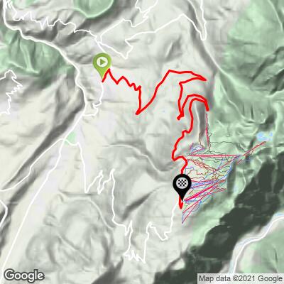
 Chamrousse from Saint-Martin-d'Uriage climbs 1,157 m (3,796 ft) over 18.9 km (11.7 mi), from 587 m (1,926 ft) to 1,744 m (5,721 ft), at an average grade of 6.1%.
The steepest 100 yards (91 m) reach 10.6%, the steepest quarter mile (0.4 km) averages 9.7%, and the steepest half mile (0.8 km) 9.4%. The steepest mile (1.6 km) holds 8.9%, the steepest 5 km (3.1 mi) 8.2%, and the steepest 10 km (6.2 mi) 7.0%.
That profile shows a climb with a hard first act and a gentler second one: the grade only just tops 10% in short pitches, the difficulty is front-loaded, and after the Seiglières pass the road becomes far more manageable apart from about one kilometer at 9%.
Roadway: The D111 is paved and well maintained throughout. The tourist office's marked cycling route is officially open from May through October, but the road itself stays open through winter for ski-resort access, so expect snow and ice at elevation outside the summer season. The descent has a noticeably better surface than the climb and is smooth and fast.
Traffic: Light to moderate. Resort traffic peaks in the winter ski season and on summer weekends, so weekday mornings are the calmest time to ride.
Parking: The tourist office's marked route starts at the first roundabout by the Parc d'Uriage in Uriage-les-Bains, with a bus stop within 500 m, and the free street parking near the center of Uriage described on our Chamrousse page works here too. At the top, the Recoin and Roche Béranger lots are useful if you want to start from the resort.
Provisions: There is nothing along the lower forested part of the road, so fill bottles before leaving Saint-Martin-d'Uriage or Uriage-les-Bains. The Auberge des Seiglières lies on the route where the climb eases, and the resort at the top has cafes, restaurants and shops, though hours are shorter outside the ski and summer hiking seasons.
Gear: The grade is moderate overall, but the early pitches around 10% reward a compact crankset. Temperatures at 1,744 m (5,721 ft) are noticeably cooler than in the valley, so pack a wind layer for the top and the descent.
Before heading out on any cycling adventure check out our Things to Bring on a Cycling Trip and use our interactive check list to ensure you don't forget anything.
Saint-Martin-d'Uriage is the quieter village above Uriage-les-Bains, whose sulphide-and-salt thermal waters have been used since Roman times. For a longer day, the tourist office's 40 km (24.9 mi) loop climbs via Vaulnaveys and the Chartreuse de Prémol, continues to the Col de Chamrousse at 1,795 m (5,889 ft), and returns down this Saint-Martin-d'Uriage road. Our Chamrousse and Chamrousse (Séchilienne) pages cover the other approaches, including the Croix de Chamrousse cable car and the Luitel reserve.
At the top, Recoin (1,650 m) and Roche Béranger (1,750 m) are the two centers of the resort, and the 1968 Olympic history is worth a look around. The marked cycling route is open from May to October.
Check current conditions at the resort before you go with our Weather tool.
ROUTE MAP
MEMBER RATING
CURRENT WEATHER
PJAMM TRIPS ADVENTURE STARTER BUNDLES
Check out PJAMM Adventure's prepackaged (self-guided) cycling trips. They will help you plan, document and conquer your next adventure.
NEARBY CLIMBS (0) RADIAL PROXIMITY
FROM No Climbs Found
MEMBER REVIEWS & COMMENTS
Let us know what you thought of this climb. Signup for our FREE membership to write a review or post a comment.
Already have an account?
LOG IN HERE
