
23.3
PDI
10.6 mi
DISTANCE
3,837 ft
GAINED
6.5 %
AVG. GRADE
FULL CLIMB STATS
INTRO
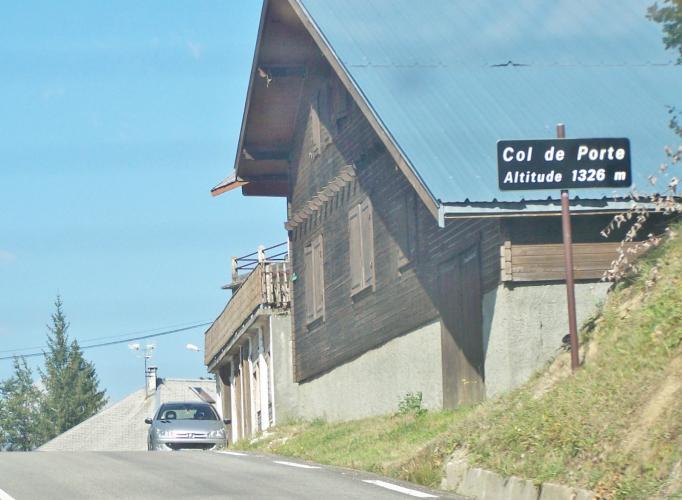
This is the back-road way to Col de Porte, the Chartreuse's most famous pass. Starting on the banks of the Isère at the edge of Grenoble, it climbs 17.0 km (10.6 mi) and 1170 m (3,837 ft) at an average grade of 6.5% to the col at 1326 m (4,350 ft), collecting three smaller cols along the way - Clémencières, the unmarked crossing at Sarcenas, and Palaquit - on roads that most traffic bound for Col de Porte never sees.
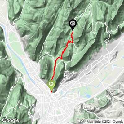
It's a climb of two hard efforts split by a breather. The Route de Clémencières rears straight up out of Saint-Martin-le-Vinoux for 5.3 km (3.3 mi) at about 8% to the Col de Clémencières at 622 m (2,041 ft), with views back over Grenoble and across to the Vercors. After a short descent toward Quaix-en-Chartreuse and the Pont de Vence, the D57 climbs through forest to the tiny village of Sarcenas at over 9% for roughly 4.5 km (2.8 mi) - the crux of the ride. From there the grade eases to the Col de Palaquit at 1154 m (3,786 ft), where you join the main D512 for the final 2.5 km (1.6 mi) to Col de Porte.
The col sits at the foot of Chamechaude, at 2082 m (6,831 ft) the highest summit in the Chartreuse, and is home to a small family ski area and a long-running snow research station: Météo-France's snow research center has recorded weather and snowpack here every season since 1960-61. The Col de Porte has a long Tour de France history too - see our Col de Porte (Grenoble) page for that side of the story.
PLAN YOUR ROUTE
 We've partnered with Sherpa-Map.com to bring you the best route planning tool. With a PRO Membership you can use this climb as a reference when creating your route.
 Col de Porte via Col de Clémencières climbs 17.0 km (10.6 mi) from 217 m (712 ft) at the edge of Grenoble to 1326 m (4,350 ft), gaining 1170 m (3,837 ft) at an average grade of 6.5%. That average includes about 2 km (1.2 mi) of descending after the Col de Clémencières - the climbing sections themselves average closer to 8%.
The route breaks into four parts: 5.3 km (3.3 mi) at about 8% to the Col de Clémencières (622 m); a short descent of about 60 m (197 ft) toward the Pont de Vence; roughly 4.5 km (2.8 mi) at over 9% up the D57 to Sarcenas, the hardest stretch of the day, with a kilometer at 9.9%; then a steadier 7% or so over the last 4 km (2.5 mi) via the Col de Palaquit to the summit.
The steepest 0.5 km (0.3 mi) averages 10.3%, the steepest kilometer 10.2%, the steepest 2 km (1.2 mi) 10.0%, and the steepest 5 km (3.1 mi) 9.2%.
Roadway: Paved the entire way. The Route de Clémencières is a well-surfaced suburban road; the D57 between Quaix-en-Chartreuse and Sarcenas is narrower, climbs through steep forest, and has needed repeated safety work in recent years - a February 2021 landslide closed it for months, and there were further works near the Pont de Vence in 2024 and resurfacing on the Col de Clémencières / Col de Vence road in October 2025. Check Grenoble-Alpes Métropole's road-works notices before you ride. The final stretch from the Col de Palaquit is on the main D512.
Traffic: The Clémencières road carries a fair amount of local traffic out of Saint-Martin-le-Vinoux. Beyond the col, the D57 through Sarcenas is very quiet - that's the real appeal of this route. Traffic picks up again on the D512 from the Col de Palaquit to Col de Porte, the main road between Grenoble and Saint-Pierre-de-Chartreuse, which is busiest on weekends.
Parking: The big free car park on Grenoble's Esplanade closed in March 2025 and is being turned into an urban park, so don't count on it. The Esplanade park-and-ride (P+R) lot remains, free with a valid local transit ticket - otherwise, the start is an easy ride from central Grenoble. At the top, there's parking at the Col de Porte for anyone meeting riders or doing only the upper section.
Provisions: Grenoble and Saint-Martin-le-Vinoux have everything you need before the start. Once you leave town there are no shops on the route through Clémencières and Sarcenas, so carry enough water for the full climb. At the col, the Restaurant des 3 Sommets serves drinks and food, but its hours are limited - lunchtime until 17:30 during school holidays and on weekends otherwise - so don't rely on it midweek.
Gear: A compact crankset with a wide-range cassette makes the 9-10% pitches up to Sarcenas far more manageable. The lower slopes above Saint-Martin-le-Vinoux face the sun and get hot in the afternoon - an early start is the cooler choice in summer. Snow can linger near the top well into spring, and the col runs as a ski area in winter.
Before heading out on any cycling adventure check out our Things to Bring on a Cycling Trip and use our interactive check list to ensure you don't forget anything.
This route strings together a handful of small places that the main roads bypass. The Col de Clémencières is a local favorite for Grenoble riders with the Néron's cliffs looming overhead, and Sarcenas - a small village high on the slope - is the commune the Col de Porte itself belongs to.
At the top, look for the measurement field of the Col de Porte snow research site: its season-by-season record since 1960-61 is used to build and test snowpack models and to track climate change in the Alps. The col is also the trailhead for Chamechaude and the start of the narrow road up to Charmant Som, the highest paved point in the Chartreuse.
Col de Porte is the first leg of the classic Chartreuse trilogy with the Col du Cucheron and Col du Granier, and there are several other ways up from Grenoble. See other climbs nearby, or build a custom route from here, with our Routes in the Area tool.
ROUTE MAP
MEMBER RATING
CURRENT WEATHER
PJAMM TRIPS ADVENTURE STARTER BUNDLES
Check out PJAMM Adventure's prepackaged (self-guided) cycling trips. They will help you plan, document and conquer your next adventure.
NEARBY CLIMBS (0) RADIAL PROXIMITY
FROM No Climbs Found
MEMBER REVIEWS & COMMENTS
Let us know what you thought of this climb. Signup for our FREE membership to write a review or post a comment.
Already have an account?
LOG IN HERE
