
25
PDI
7.8 mi
DISTANCE
3,473 ft
GAINED
8.5 %
AVG. GRADE
FULL CLIMB STATS
INTRO
PLAN YOUR ROUTE
 We've partnered with Sherpa-Map.com to bring you the best route planning tool. With a PRO Membership you can use this climb as a reference when creating your route.
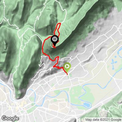
 Fort du Saint-Eynard averages 8.5% over 12.6 km (7.8 mi), gaining 1,058.6 m (3,473 ft) from 255.7 m (839 ft) in Meylan to 1,314.6 m (4,313 ft) at the fort.
The grade is very unevenly distributed. The lower kilometers through Meylan and Corenc are moderate by comparison, rolling through urban terrain up to the Col de Vence at 782 m - roughly the midpoint by elevation, with about 7 km still to go from there. The climb's difficulty is concentrated in its final 4 km, which average well over 10% as the road narrows into the forest and switches back through a series of increasingly tight hairpins with no real flat sections to recover on.
Roadway: Paved the entire way and reported in good condition, including through the steep switchbacks of the final 4 km. The road to the fort is closed to traffic in winter, reopening in spring - check with the fort's own office (open in summer) or Grenoble-area tourism sites for current-year opening dates before planning an early- or late-season ride.
Traffic: Busiest in the lower section through Meylan and Corenc, which is dense suburban Grenoble terrain with regular local traffic. Above the Col de Vence, traffic drops off considerably - the road serves only the fort itself, so it sees hikers' and tourists' cars in summer but little through traffic.
Parking: Meylan's Innovallée district, where the climb starts, has ordinary street parking suited to an urban start. At the top, there's parking near the fort itself, including space large enough for tour coaches, since the fort operates as a small museum and restaurant in season.
Meylan and Corenc, in the lower third of the climb, are ordinary Grenoble suburbs with shops, bakeries, and cafes for a pre-ride stop. Once you're past Corenc and climbing toward the Col de Vence, services disappear - there's nothing along the road itself until the fort. At the top, the fort's restaurant and small shop operate seasonally in summer, but shouldn't be relied on outside that window.
Given the steep, sustained final 4 km at over 10%, a compact or triple crankset is worth having if you're not used to climbs in that range - there's no flat stretch to recover on before the summit.
Before heading out on any cycling adventure check out our Things to Bring on a Cycling Trip and use our interactive check list to ensure you don't forget anything.
Meylan is a workaday Grenoble suburb rather than a tourist base, so most riders treat this as a half-day climb from Grenoble itself rather than a destination to stay in. The city has the area's full range of hotels, restaurants, and bike shops if you're building a longer Chartreuse trip around it.
Fort du Saint-Eynard is one of a ring of forts built around Grenoble after the 1870 Franco-Prussian War, and its small on-site museum (open summer only) covers that history along with the fort's role and construction. The panoramic view from the ramparts - Grenoble, the Belledonne range, the Vercors, and the Chamechaude cliffs - is a genuine reason to budget extra time at the top beyond just turning around.
Because the final approach is a dead end with no other roads, riders looking to extend the day usually do it as an out-and-back before continuing on to the Chartreuse's other classic climbs - Col de Porte and Col du Coq are both in the same range - rather than trying to link this fort directly into a loop.
ROUTE MAP
MEMBER RATING
CURRENT WEATHER
PJAMM TRIPS ADVENTURE STARTER BUNDLES
Check out PJAMM Adventure's prepackaged (self-guided) cycling trips. They will help you plan, document and conquer your next adventure.
NEARBY CLIMBS (0) RADIAL PROXIMITY
FROM No Climbs Found
MEMBER REVIEWS & COMMENTS
Let us know what you thought of this climb. Signup for our FREE membership to write a review or post a comment.
Already have an account?
LOG IN HERE
