
21.6
PDI
11.8 mi
DISTANCE
3,792 ft
GAINED
6.1 %
AVG. GRADE
FULL CLIMB STATS
INTRO
PLAN YOUR ROUTE
 We've partnered with Sherpa-Map.com to bring you the best route planning tool. With a PRO Membership you can use this climb as a reference when creating your route.
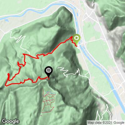
 The Pas du Mortier averages 6.0% over 19.0 km (11.8 mi), but the profile is front-loaded: the steepest 10 km (6.2 mi) average 6.7%, the steepest 5 km (3.1 mi) 8.8%, the steepest 2 km (1.2 mi) 10.4% and the steepest kilometre 11.0%, with the steepest 100 yards (91 m) at 12.1%.
Riders report steep sections through Veurey-Voroize at the start, and the grade eases after Montaud, so the opening kilometres are harder than the average suggests.
Roadway: The road is paved from Veurey-Voroize through Montaud to Les Coings, narrow and winding along the torrent. Beyond Les Coings the D218 has been closed to vehicles since a rockfall collapsed it in 1992, and further slides have followed. The tarmac is heavily damaged under thick gravel, and the rockfall about 1 km (0.6 mi) below the tunnel has to be crossed on foot. Check local conditions, for example Isère's Inforoute38, before attempting the upper section.
Traffic: Light. The lower road serves only Veurey-Voroize and Montaud and is a dead end, and above Les Coings there is no motor traffic at all.
Parking: Veurey-Voroize is a village of about 1,400 people, and the climb starts in the village itself, so there is no dedicated trailhead lot to look for. Any considerate roadside spot in the village will do.
Gear: A mountain bike or gravel bike with wide tyres suits the upper road, or wear shoes you can walk in, as the rockfall crossing means carrying the bike. Carry a headlamp for the tunnel.
Provisions: Carry all the water and food you need above Montaud, as there are no services on the closed upper road.
Before heading out on any cycling adventure check out our Things to Bring on a Cycling Trip and use our interactive check list to ensure you don't forget anything.
Veurey-Voroize sits in the foothills of the Vercors cliffs, within the Vercors Regional Natural Park, and it has a medieval Templars' tower from the 13th-14th century and a neo-Gothic church, Saint-Georges, built in 1853 on the ruins of an 11th-century one. The area produces IGP Coteaux-du-Grésivaudan wines if you want to reward yourself afterwards.
Montaud, the plateau village higher up, has a statue of Notre-Dame-des-Sommets on a hilltop above it, and hiking trails to the Dent de Moirans and the Pas de la Clé; see our Saint-Quentin-sur-Isère page for the other approach and the story of the 1968 Olympic tunnel. From the tunnel viewpoint riders look out over the Isère valley toward the Chartreuse, which you can ride from Saint-Égrève on our Col de la Charmette climb.
Some riders continue through the tunnel and descend via Autrans on the other side, so plan your descent before you set out.
ROUTE MAP
MEMBER RATING
CURRENT WEATHER
PJAMM TRIPS ADVENTURE STARTER BUNDLES
Check out PJAMM Adventure's prepackaged (self-guided) cycling trips. They will help you plan, document and conquer your next adventure.
NEARBY CLIMBS (0) RADIAL PROXIMITY
FROM No Climbs Found
MEMBER REVIEWS & COMMENTS
Let us know what you thought of this climb. Signup for our FREE membership to write a review or post a comment.
Already have an account?
LOG IN HERE
