
21.7
PDI
11.7 mi
DISTANCE
3,787 ft
GAINED
6.1 %
AVG. GRADE
FULL CLIMB STATS
INTRO
PLAN YOUR ROUTE
 We've partnered with Sherpa-Map.com to bring you the best route planning tool. With a PRO Membership you can use this climb as a reference when creating your route.
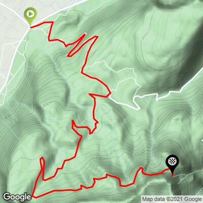
 The Pas du Mortier averages 6.1% over 18.8 km (11.7 mi) and never becomes extreme: the steepest 10 km average 7.0%, the steepest 5 km 8.2% and the steepest kilometer 9.0%, with the steepest 100 yards (91 m) at 10.2%.
The steepest pitches are in the lower kilometers out of Saint-Quentin-sur-Isère and up to Montaud. After the village the grade moderates as the road enters the forest.
Roadway: The road is paved, but the D218 is officially closed to vehicles above Montaud. The upper sections have deteriorated, with potholes and rockfall damage, and a series of rockfalls (notably around 2021, with further debris reported in the winter of 2023-2024) has buried parts of the road below the tunnel. Volunteers have built a wooden staircase across one slide, but passage means carrying the bike over rubble. Check local conditions, for example Isère's Inforoute38, before attempting the upper section.
Traffic: Only local traffic on the lower road around Saint-Quentin-sur-Isère and Montaud; above the closure there is essentially none.
Parking: Saint-Quentin-sur-Isère is a village of about 1,470 people, and the climb starts right in the village, so any considerate spot near the start works.
Gear: Standard compact gearing is enough; the grades stay near 10% at most. If you plan to continue past the closure, wear shoes you can walk over rubble in.
Provisions: Fill bottles in the valley, as there are no services on the closed upper road. The route is shaded most of the day, which helps in summer, but it is exposed to wind at altitude, so bring a windproof layer even in summer.
Before heading out on any cycling adventure check out our Things to Bring on a Cycling Trip and use our interactive check list to ensure you don't forget anything.
Montaud, the plateau village at about 740 m, has a distinctive stone church steeple and is the start of the hike to the Dent de Moirans. The tunnel and the road beyond it lead to Autrans, on the Vercors plateau, which hosted the Nordic events of the 1968 Grenoble Winter Olympics.
A second approach reaches the same tunnel from the Veurey-Voroize side (see our Pas du Mortier climb from there), and Col du Mont Noir climbs the Vercors from Saint-Gervais through the Gorges des Écouges, which gives a very different day out from the same region. See other climbs nearby, or build a custom route from here, with our Routes in the Area tool.
ROUTE MAP
MEMBER RATING
CURRENT WEATHER
PJAMM TRIPS ADVENTURE STARTER BUNDLES
Check out PJAMM Adventure's prepackaged (self-guided) cycling trips. They will help you plan, document and conquer your next adventure.
NEARBY CLIMBS (0) RADIAL PROXIMITY
FROM No Climbs Found
MEMBER REVIEWS & COMMENTS
Let us know what you thought of this climb. Signup for our FREE membership to write a review or post a comment.
Already have an account?
LOG IN HERE
