
15.5
PDI
14.1 mi
DISTANCE
3,320 ft
GAINED
4.5 %
AVG. GRADE
FULL CLIMB STATS
INTRO
You start among the bus stops and apartment blocks of Grenoble's western suburbs, and within ten minutes the city is gone. The D531 swings up a few hairpins above Sassenage, the Vercors cliffs fill the windshield, and the road dives into the Gorges du Furon, a limestone slot with the torrent down in the trees beside the road. Look back near Engins and the Chartreuse is lined up across the Isère.
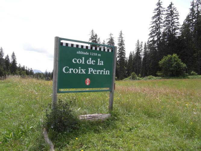
The numbers are modest: 22.6 km (14.1 mi) and 1012 m (3320 ft) of climbing at 4.5%, and the steepest kilometer is only 6.2%. What it asks for is patience. The first 12 km hold 5 to 6% almost without a break, so you can settle into a tempo and stay there all the way to Engins. Then the valley opens into the meadows of the Val de Lans and the next 5 km barely climb at all. From Lans-en-Vercors the D106 heads into the spruce for the last 4 km at 5 to 6%, and the col is a clearing with a green sign and the Auberge de la Croix Perrin, which serves lunch on its terrace most of the year.
The catch is the traffic. The D531 is the main road from Grenoble onto the northern Vercors, busy with commuters and delivery vans on weekdays and with skiers and day-trippers at weekends, and riders say cars are fast above Lans. Ride it early on a weekday, or come down the other side to Autrans and Méaudre and leave the main road behind.
PLAN YOUR ROUTE
 We've partnered with Sherpa-Map.com to bring you the best route planning tool. With a PRO Membership you can use this climb as a reference when creating your route.
The 22.6 km (14.1 mi) climb gains 1012 m (3320 ft) at an average of 4.5%, from 206 m (675 ft) in Sassenage to 1215 m (3985 ft) at the end of our GPX, a few meters below the col sign (1218 m).
This is about as steady as a long climb gets. The steepest kilometer averages 6.2%, the steepest 2 km average 5.9% and the steepest 5 km average 5.6%.
Km 0 to 12: Sassenage to Engins on the D531, 5 to 6% the whole way - hairpins above Sassenage, then the Gorges du Furon. You reach about 850 m.
Km 12 to 17: the Val de Lans, just 1 to 2.5%, to about 940 m.
Km 17 to 19: a short rise to Lans-en-Vercors at about 1010 m.
Km 19 to 22.6: the D106 to the col, 5 to 6% through the forest.
Roadway: Good, wide tarmac on both the D531 and the D106, and riders consistently rate the surface very good. Snow and ice are normal above Engins from late autumn to spring. Check Isère's itinisere.fr for closures and roadworks before you go.
Traffic: The weak point. The D531 between Sassenage and Lans-en-Vercors carries most of the traffic between Grenoble and the northern Vercors, with delivery trucks early in the morning and commuters in the evening on weekdays, and visitors at weekends and in the ski season. The last 4 km on the D106 are a little quieter, but riders report fast cars there too. Weekday mid-mornings are the calmest window.
Parking: The P+R Sassenage Jean Prévost car park on Place Jean Prévost, right at the start beside the Château de Sassenage, has about 80 spaces and is free to enter and leave. Buses 20, 50 and 54 stop at Château de Sassenage nearby if you're coming from Grenoble without a car.
Gear: With nothing steeper than about 6%, a standard compact is plenty, and this is a good climb for a steady tempo effort. The col is about 1000 m above Sassenage and the plateau is noticeably colder and windier than the city, with a headwind common over the last few hundred meters, so carry a windproof for the top and the long descent.
Provisions: Sassenage has bakeries and shops at the bottom. Engins is small; Lans-en-Vercors, around km 19, has shops and cafés for a refill before the final pull. At the col, the Auberge de la Croix Perrin has a bar and restaurant with a big terrace; it's open daily for most of the year but closes for a couple of weeks in spring and late autumn.
Before heading out on any cycling adventure check out our Things to Bring on a Cycling Trip and use our interactive check list to ensure you don't forget anything.
Grenoble is the easy base, with every kind of hotel, bike shops and good trains, and Sassenage is on its doorstep. At the bottom of the climb, the Cuves de Sassenage are a cave system on the Furon with guided tours by booking, tied to the local legend of the water fairy Mélusine, and the château beside the car park is the start line for this ride.
For a loop, carry on over the col and drop to Autrans, which hosted the cross-country, biathlon and Nordic combined events of the 1968 Grenoble Winter Olympics, then come back through Méaudre and Lans. Saint-Nizier-du-Moucherotte, with the Resistance necropolis and the 1968 ski jump, is a short ride from Lans-en-Vercors and has its own page. Côte d'Engins starts at the same spot and covers just the first, gorge section of this climb.
ROUTE MAP

MEMBER RATING
CURRENT WEATHER
PJAMM TRIPS ADVENTURE STARTER BUNDLES
Check out PJAMM Adventure's prepackaged (self-guided) cycling trips. They will help you plan, document and conquer your next adventure.
NEARBY CLIMBS (0) RADIAL PROXIMITY
FROM No Climbs Found
MEMBER REVIEWS & COMMENTS
Let us know what you thought of this climb. Signup for our FREE membership to write a review or post a comment.
Already have an account?
LOG IN HERE
