
18.2
PDI
9.3 mi
DISTANCE
3,115 ft
GAINED
6.4 %
AVG. GRADE
FULL CLIMB STATS
INTRO
St. Nizier-du-Moucherotte is the classic way onto the Vercors from Grenoble. From Seyssinet-Pariset, just across the Drac from the city, it climbs 14.9 km (9.3 mi) and gains 949 m (3,115 ft) at a 6.4% average grade to the western end of Saint-Nizier village at 1,169 m (3,836 ft), on the edge of the Vercors plateau. It ranks #221 in France by our rankings.
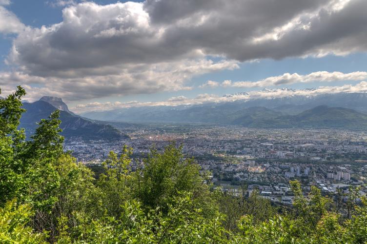
This is a balcony road. It leaves the suburbs through a few hairpins between villas, climbs through woods past the quarter of the Tour sans Venin, joins the D 106 from Seyssins, and works up through the hamlet of Pariset to the plateau. The views keep growing the whole way - Grenoble spread out below, the Isère valley, the Chartreuse across the river and the Belledonne range behind - and near the top the Moucherotte (1,901 m / 6,237 ft), the easternmost peak of the Vercors, rises over the village that carries its name.
History runs close to the road. The first Resistance memorial appears at Les Guillets, and just below the village is the national necropolis that remembers the fighting of June 1944, when about 250 maquisards held off German attacks on this slope before being overwhelmed by a much larger force. Above the village, the ski jump that hosted the large-hill event of the 1968 Grenoble Winter Olympics still stands, unused since it closed in 1990.
PLAN YOUR ROUTE
 We've partnered with Sherpa-Map.com to bring you the best route planning tool. With a PRO Membership you can use this climb as a reference when creating your route.
St. Nizier-du-Moucherotte averages 6.4% over 14.9 km (9.3 mi), gaining 949 m (3,115 ft) from 221 m (725 ft) in Seyssinet-Pariset to 1,169 m (3,836 ft) at the top of Saint-Nizier.
It's a steady climb with no real surprises. The first 7 km (4.3 mi) mostly sit between 5.8% and 6.9%, then the road steepens through the middle: the steepest kilometer averages 8.3%, the steepest 2 km (1.2 mi) average 8.2% and the steepest 500 m (0.3 mi) 8.7%, all of it between roughly km 7 and km 9 as the road climbs toward Pariset. The steepest 100 m (109 yd) reaches 9.6%.
The steepest 5 km (3.1 mi) average 7.4% and the steepest 10 km (6.2 mi) 6.9%, so expect the hardest work in the middle third. The last 2 km (1.2 mi) through the village ease to about 5.5-6%, a good place to recover before the descent or the ride on toward Lans-en-Vercors.
Roadway: Paved and well-built the whole way. The lower section is the D 106B, the Route de Saint-Nizier, a two-lane road climbing through residential Seyssinet-Pariset and then woods; from about the third hairpin it merges with the D 106 from Seyssins, which carries on through Pariset to Saint-Nizier as the Route du Vercors. Above about 1,000 m (3,281 ft), snow and ice are possible in winter, so check conditions before a cold-season ride.
Traffic: Moderate. This is a working road between Grenoble and the northern Vercors, and it's never traffic-free with a city this close, though riders describe even Sunday traffic as manageable. The D 106B start from Seyssinet is calmer than the D 106 up from Seyssins, which is the busier of the two lower roads. Weekday mornings are the quietest time to ride.
Parking: There's no dedicated parking for cyclists at the start, which is on a residential road near Seyssinet-Pariset's town centre. The easiest option is to come without a car: the Seyssinet-Pariset Hôtel de Ville stop on Grenoble's tram Line C is a few minutes' ride from the start. If you're driving, there's a hikers' car park in the woods a little above the first hairpins, and parking near the necropolis just below Saint-Nizier for anyone meeting riders at the top.
Provisions: Stock up in Seyssinet-Pariset or Grenoble - Saint-Nizier is a small village of about 1,160 residents, and the climb itself passes mostly homes, woods and the hamlet of Pariset, so carry enough water for the full climb, especially on hot summer days on this east-facing slope.
Gear: Standard compact gearing is plenty for grades that rarely pass 8.5%. You finish nearly 950 m (3,117 ft) above Grenoble, where it is often several degrees cooler and can be windy on the plateau edge, so bring a jacket for the descent. If you're heading on into the Vercors, the plateau beyond the village is far more exposed than the sheltered lower road.
Before heading out on any cycling adventure check out our Things to Bring on a Cycling Trip and use our interactive check list to ensure you don't forget anything.
Three stops make this climb more than a training ride. Around km 6.8 a signed turn leads to the Tour sans Venin, a ruined 13th-century tower just above the road that is one of the Seven Wonders of the Dauphiné. It's free and open all year, and an orientation table there identifies Belledonne, the Chartreuse and, on clear days, Mont Blanc.
Higher up, at around km 12.3 and right beside the road, the Nécropole de Saint-Nizier holds the graves of Vercors Resistance fighters, including the writer Jean Prévost (Captain Goderville) and the maquis' civilian leader Eugène Chavant. It's free to visit and has one of the best views of Grenoble and the Alps anywhere on the climb. Near the top of the village, a short detour leads to the 1968 Olympic ski jump, built in 1966-67 for the large-hill event and disused since 1990; the Trois Pucelles rocks, used by the maquis in 1944, stand at the foot of the Moucherotte nearby.
Saint-Nizier is the gateway to the northern Vercors, and Lans-en-Vercors and Villard-de-Lans are a short ride further on - see other climbs nearby, or build a custom route from here, with our Routes in the Area tool.
ROUTE MAP

MEMBER RATING
CURRENT WEATHER
PJAMM TRIPS ADVENTURE STARTER BUNDLES
Check out PJAMM Adventure's prepackaged (self-guided) cycling trips. They will help you plan, document and conquer your next adventure.
NEARBY CLIMBS (0) RADIAL PROXIMITY
FROM No Climbs Found
MEMBER REVIEWS & COMMENTS
Let us know what you thought of this climb. Signup for our FREE membership to write a review or post a comment.
Already have an account?
LOG IN HERE
