
25.6
PDI
7.2 mi
DISTANCE
3,425 ft
GAINED
8.8 %
AVG. GRADE
FULL CLIMB STATS
INTRO
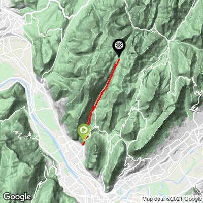
Col de la Charmette climbs 11.5 km (7.2 mi) out of Saint-Égrève, a Grenoble suburb, into the Chartreuse massif, gaining 1,044 m (3,425 ft) at an 8.8% average grade to the pass at 1,280 m (4,198 ft). It's rated Hors Catégorie for good reason - the road is paved the entire way but stays narrow throughout, with pitches reported near 17% on the way up.
Past the col, the old forestry road that once continued through the Chartreuse toward Saint-Laurent-du-Pont hasn't been maintained in decades and is now closed to cars, which keeps this a true dead-end climb by road bike rather than a through-route. Dense Chartreuse forest lines most of the ascent, with views opening up only in the final switchbacks near the top.
The renovated Chalet de la Charmette sits right at the pass, serving simple, locally-sourced meals and overnight stays, and marks the trailhead for hikes up Charmant Som, Grande Sure, and Pinéa - all recognizable peaks of the Chartreuse Regional Natural Park.
PLAN YOUR ROUTE
 We've partnered with Sherpa-Map.com to bring you the best route planning tool. With a PRO Membership you can use this climb as a reference when creating your route.
 Col de la Charmette gains 1,044 m (3,425 ft) over 11.5 km (7.2 mi) at an 8.8% average grade, finishing at 1,280 m (4,198 ft). The steepest kilometer averages 11.6% and the steepest mile 11.2%, with reported pitches near 17% on some of the tighter switchbacks. There's little flat ground to recover on anywhere along the route - this is a steady, sustained grind from the first pedal stroke in Saint-Égrève to the pass.
Roadway: The D105 is paved the entire way from Saint-Égrève to the pass, but stays narrow throughout with limited passing room and no shoulder in most places. Past the Col de la Charmette, the old forestry road toward Saint-Laurent-du-Pont hasn't been maintained in decades and is closed to cars - it's rideable on a gravel bike but not a road bike, so treat this as a dead-end climb and plan to descend the way you came up.
Traffic: Light once you clear Saint-Égrève itself. This is a quiet mountain road used mostly by locals, hikers headed for the Chartreuse trailheads, and other cyclists, with no significant through-traffic since the road doesn't continue as a drivable pass.
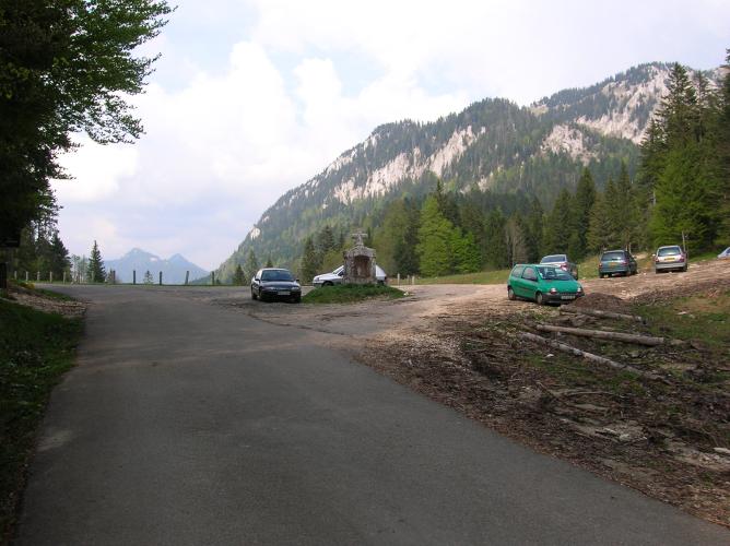
Parking: Free parking is available near the D105/D105A junction at the edge of Saint-Égrève, close to the town's war memorial, where the climb effectively begins.
Bring low gearing - the sustained 8.8% average with pitches near 17% leaves little chance to spin an easy cadence anywhere on the climb. The road is fully paved, so a standard road bike is fine, though wider tires add comfort on the narrower upper sections. Saint-Égrève and greater Grenoble have every kind of shop and cafe for stocking up beforehand; above town there's nothing until the Chalet de la Charmette at the very top, so carry enough water for the full 11.5 km (7.2 mi) ascent.
Before heading out on any cycling adventure check out our Things to Bring on a Cycling Trip and use our interactive check list to ensure you don't forget anything.
Saint-Égrève is a Grenoble suburb, so pre- or post-ride logistics are easy - restaurants, bike shops, and hotels of every kind are a short drive away in the city itself. At the top, the recently renovated Chalet de la Charmette serves simple, locally-sourced meals and overnight stays right at the pass, and makes a good reason to linger before heading back down.
The Chalet also marks the trailhead for hikes up Charmant Som, Grande Sure, and Pinéa - worth knowing if you want to extend the day on foot. See other climbs around Grenoble and the Chartreuse massif, including the popular Col de Porte and Charmant Som routes out of nearby La Tronche, with our Routes in the Area tool.
ROUTE MAP
MEMBER RATING
CURRENT WEATHER
PJAMM TRIPS ADVENTURE STARTER BUNDLES
Check out PJAMM Adventure's prepackaged (self-guided) cycling trips. They will help you plan, document and conquer your next adventure.
NEARBY CLIMBS (0) RADIAL PROXIMITY
FROM No Climbs Found
MEMBER REVIEWS & COMMENTS
Let us know what you thought of this climb. Signup for our FREE membership to write a review or post a comment.
Already have an account?
LOG IN HERE
