
25.3
PDI
8.2 mi
DISTANCE
3,637 ft
GAINED
7.9 %
AVG. GRADE
FULL CLIMB STATS
INTRO
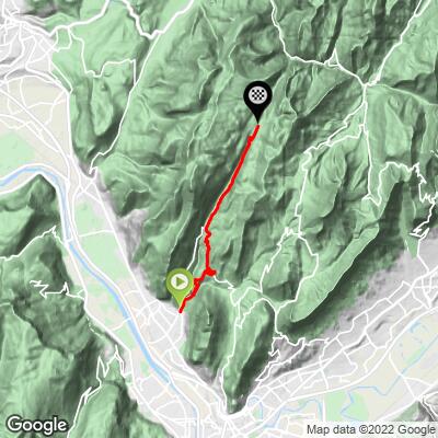
The Route de Saint-Égrève climbs 13.2 km (8.2 mi) out of Saint-Égrève, a Grenoble suburb, into the Chartreuse massif, gaining 1,109 m (3,637 ft) at a 7.9% average grade to finish at Col de la Charmette, 1,280 m (4,198 ft). It reaches the same summit as our separate Col de la Charmette page, but takes a longer, gentler-graded path through the village of Proveysieux rather than the more direct route - a real option if you'd rather trade a steeper, narrower finish for extra distance and a village stop along the way.
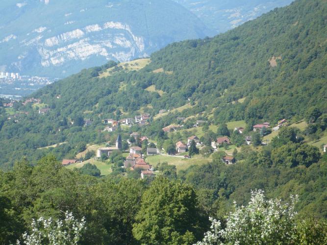
The road climbs steadily out of Saint-Égrève's Clapières neighborhood into forested hillside, opening onto wide views back down over the Saint-Égrève and Grenoble valley as it gains height. Proveysieux itself, about two-thirds of the way up, is a small, historic hillside village with a 12th-century church and a set of old fountains and oratories - a natural place to refill water and take in the view before the final push.
Past the village, the road continues climbing through the Coulmes foothills to rejoin the direct Charmette route for the final approach to the pass.
At the summit, the recently renovated Chalet de la Charmette serves meals and overnight stays right at the pass, and marks the trailhead for hikes up Charmant Som, Grande Sure, and Pinéa - see our Col de la Charmette page for more on what's at the top, since this route shares that final approach and everything at the summit itself.
PLAN YOUR ROUTE
 We've partnered with Sherpa-Map.com to bring you the best route planning tool. With a PRO Membership you can use this climb as a reference when creating your route.
 The Route de Saint-Égrève averages 7.9% over 13.2 km (8.2 mi), a notch gentler on paper than the direct Col de la Charmette route, but it isn't an easy alternative - the steepest 100 yards here reaches 21.2%, and the steepest full mile averages 12.1%, both sharper than the direct route's numbers.
The lower kilometers out of Saint-Égrève hold a moderate, sustainable grade through forest. The road through Proveysieux village offers a brief respite before the route steepens again beyond it, with the steepest, punchiest ramps concentrated in the final kilometers as the road rejoins the direct approach to close in on Col de la Charmette.
Roadway: Paved the entire way from Saint-Égrève to Col de la Charmette. The road is wider and more open through the lower slopes and Proveysieux village than the narrow, dead-end final stretch it shares with the direct Charmette route near the pass. As with the direct route, the old forestry road beyond the pass toward Saint-Laurent-du-Pont is closed to cars, so plan to descend the way you came up.
Traffic: Light. The lower road through Saint-Égrève's outskirts and Proveysieux carries some local traffic, but it thins out noticeably above the village, with the final kilometers to the pass seeing mostly hikers and other cyclists.
Parking: Free parking is available on the street near the start on Route de Quaix, in the Clapières neighborhood of Saint-Égrève.
A compact crank with a wide-range cassette (30-32 teeth) covers this climb comfortably - the sustained mid-climb grades are manageable, but the steep ramps in the final kilometers, up into the low 20s in percentage terms, reward having an easy gear in reserve.
Proveysieux, about two-thirds of the way up, is the most realistic stop for water on the route - the village's old fountains are worth seeking out if you need to refill.
There's nothing else open along the way, so plan around that one stop.
Check your gearing and brakes before you go given the mix of sustained climbing and sharp ramps, and note there are no bike shops along the route - Grenoble, just south of Saint-Égrève, has the nearest full-service options.
Before heading out on any cycling adventure check out our Things to Bring on a Cycling Trip and use our interactive check list to ensure you don't forget anything.
Saint-Égrève is a Grenoble suburb, so pre- or post-ride logistics are easy - restaurants, bike shops, and hotels of every kind are a short drive away in the city itself. This climb and our separate Col de la Charmette page share the same start area and finish at the identical summit, so if you're deciding between them: this route is the longer option through Proveysieux, while the direct route is shorter and steeper throughout.
Proveysieux itself is worth lingering in - a small hillside village that was once home to a cluster of 19th-century painters drawn to its light and views, with a 12th-century church and old stone fountains bearing the Carthusian Order's "cross over globe" emblem, a reminder that this whole region takes its name from the monks of the Grande Chartreuse.
Ride between late spring and early fall; snow can linger into late spring on the upper, shaded kilometers near the pass. See other climbs around Grenoble and the Chartreuse massif with our Routes in the Area tool.
ROUTE MAP
MEMBER RATING
CURRENT WEATHER
PJAMM TRIPS ADVENTURE STARTER BUNDLES
Check out PJAMM Adventure's prepackaged (self-guided) cycling trips. They will help you plan, document and conquer your next adventure.
NEARBY CLIMBS (0) RADIAL PROXIMITY
FROM No Climbs Found
MEMBER REVIEWS & COMMENTS
Let us know what you thought of this climb. Signup for our FREE membership to write a review or post a comment.
Already have an account?
LOG IN HERE
