
18.9
PDI
4 mi
DISTANCE
2,238 ft
GAINED
10.6 %
AVG. GRADE
FULL CLIMB STATS
INTRO
Route de Chalais is one of the steepest climbs around Grenoble: 6.5 km (4.0 mi) from the streets of Voreppe to the Monastère Notre-Dame de Chalais, gaining 682 m (2238 ft) at an average grade of 10.6%. It's short, but there's nowhere to hide - after the first 2 km, the road averages more than 12% all the way to the top.
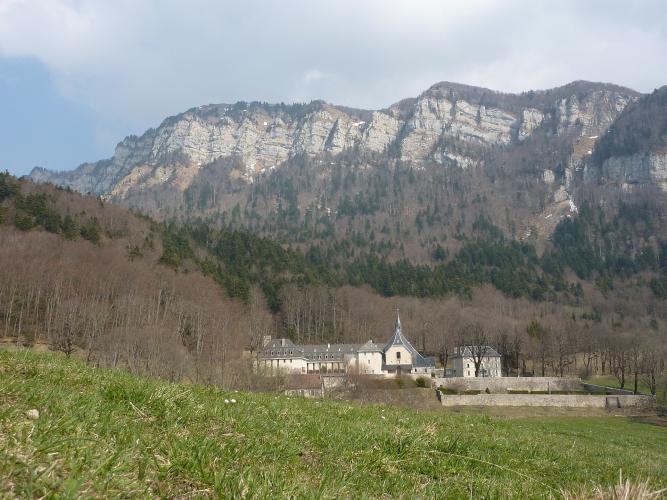
This is a quiet back road up the western edge of the Chartreuse massif, climbing through forest with few views until the very end. Then it opens onto a high, peaceful plateau at about 935 m (3068 ft), where a monastery founded in 1101 looks out over the Isère valley, the bend of the river at the northern tip of the Vercors, and the Belledonne range beyond.
Local riders compare it with Mont Saint-Martin and the Luitel, and most rate Chalais the harder of the three on its steepest sections. Bring your lowest gear and expect a slow, honest grind - the reward is one of the most unusual summits in the Alps, where the nuns of Chalais still bake biscuits behind the abbey walls. The Chartreuse and Vercors are packed with climbs like this, so see other climbs nearby, or build a custom route from here, with our Routes in the Area tool.
PLAN YOUR ROUTE
 We've partnered with Sherpa-Map.com to bring you the best route planning tool. With a PRO Membership you can use this climb as a reference when creating your route.
Route de Chalais climbs 6.5 km (4.0 mi) from 253 m (829 ft) in Voreppe to 935 m (3068 ft) at the monastery, gaining 682 m (2238 ft) at an average grade of 10.6%.
The first 2 km are a warm-up by this climb's standards, averaging 8.6% and then 6.9% as the road leaves town. Then it gets serious: km 3 averages 12.9%, km 4 11.6%, km 5 13.1% and km 6 12.0%, before the last few hundred meters ease to about 7% onto the plateau. That's roughly 4 km (2.5 mi) at better than 12%.
The steepest kilometer averages 13.8%, the steepest half kilometer 14.2%, and the steepest 2 km 12.9%. Short ramps reach 15% and more, and some riders report pitches of 16-17%.
Roadway: The Route de Chalais is a narrow, paved mountain road through the forest, ending at the monastery - beyond it, only unpaved tracks continue, so for road bikes this is an out-and-back. Rider reports on the surface are mixed: much of it is fine, but the upper part, especially the last kilometer, is rougher, with patches of gravel in places. Take the steep descent carefully.
Traffic: Light. The road leads only to Chalais, so most of the cars you'll meet are visitors heading to the monastery - riders report it's quietest in the morning and busier in the afternoon.
Parking: The climb starts in Voreppe itself, so park in town and roll to the start on the Quai du Docteur Jacquin, beside the Roize. Voreppe also has an SNCF train station, so you can reach the start by train from Grenoble and skip the car entirely. There's also parking for visitors at the monastery.
Gear: Gearing is everything here - riders who've done it recommend at least a 34x28, and a 34x32 will make the 13-14% kilometers far more manageable. Check your brakes before the descent, which drops at better than 12% for several kilometers on a narrow road.
Provisions: Fill your bottles and buy food in Voreppe - there are no cafes or shops along the route. The monastery's shop at the top sells the nuns' biscuits and other monastic products, typically in the afternoons and closed on Mondays, which makes for a memorable summit snack.
Before heading out on any cycling adventure check out our Things to Bring on a Cycling Trip and use our interactive check list to ensure you don't forget anything.
The Monastère Notre-Dame de Chalais has a remarkable history. Bishop Hugh of Grenoble settled the first monks here in 1101, and in 1303 it passed to the Carthusians of the nearby Grande Chartreuse. It was partly destroyed in the Wars of Religion in 1562 and sold off in the Revolution, then revived in 1844 by the Dominican preacher Lacordaire as a novitiate. Since 1963 it has been home to a community of Dominican nuns, who rebuilt it and support themselves by making biscuits. The Romanesque church still stands and is open to visitors (free, outside of services).
From the monastery, a walk of about an hour round trip leads to a viewpoint over the Isère valley, the Vercors and Belledonne. Back in Voreppe, the old town has a signposted historic circuit to explore on foot. Nearby, our Pas du Mortier and Col de la Charmette pages cover two very different neighboring climbs in the Vercors and Chartreuse.
ROUTE MAP

MEMBER RATING
CURRENT WEATHER
PJAMM TRIPS ADVENTURE STARTER BUNDLES
Check out PJAMM Adventure's prepackaged (self-guided) cycling trips. They will help you plan, document and conquer your next adventure.
NEARBY CLIMBS (0) RADIAL PROXIMITY
FROM No Climbs Found
MEMBER REVIEWS & COMMENTS
Let us know what you thought of this climb. Signup for our FREE membership to write a review or post a comment.
Already have an account?
LOG IN HERE
