
15.7
PDI
7.4 mi
DISTANCE
2,618 ft
GAINED
6.6 %
AVG. GRADE
FULL CLIMB STATS
INTRO
Stand in Le Touvet and look west: the Chartreuse goes up as a wall of forest topped by grey limestone cliffs, and somewhere in between there's a shelf of meadows and villages you can't see from the valley. This climb takes the D29 straight up the trees to that shelf, the Plateau des Petites Roches, and then follows it north to the small ski area at the Col de Marcieu.
It's 11.9 km (7.4 mi) with 798 m (2618 ft) of climbing, an average of 6.6%, and nearly all of the work is front-loaded. The first 9 km average close to 8% through stacked hairpins in the forest, with the steepest kilometer at 10.3% around km 4 and another long pitch over 9% just below Saint-Bernard. Then the plateau arrives, and the last 3 km to the col rise only about 100 m. It feels like a different climb once you're up there.
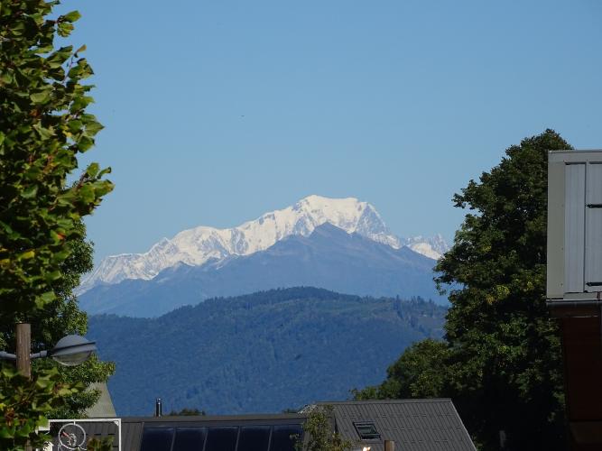
The views open the moment you leave the forest. Behind you the Belledonne range lines up across the Grésivaudan, on a clear day Mont Blanc shows over the end of it, and above Saint-Bernard the cliffs of the Dent de Crolles hang over the road. The col itself is a quiet clearing at about 1070 m with a family snow area, a restaurant at the forest edge and a road that drops away north toward Sainte-Marie-du-Mont, if you want to make a loop of it.
PLAN YOUR ROUTE
 We've partnered with Sherpa-Map.com to bring you the best route planning tool. With a PRO Membership you can use this climb as a reference when creating your route.
From Le Touvet at 277 m to the Col de Marcieu at 1066 m (909 to 3498 ft), the climb covers 11.9 km (7.4 mi) and gains 798 m (2618 ft) at an average of 6.6%.
Kilometer by kilometer: 3.5% for the first km out of Le Touvet, then 7.9%, 7%, 10%, 8.7%, 6.4%, 9.3% and 9.6% up the forest and onto the plateau, and 6.8% through Saint-Bernard-du-Touvet. Then it all but stops: 4.1%, 1.6% and 4.6% over the last 2.9 km to the col.
The steepest 1 km averages 10.3%, the steepest 0.5 km 11.2%, and the toughest 5 km 8.8%. Short ramps reach about 12% in the hairpins. If you're judging the effort, think of it as a 9 km climb at nearly 8% with a cool-down attached.
Roadway: Paved throughout. The D29 from Le Touvet is a narrow but well-kept road with a center line in places, guardrails on the drops and a long series of hairpins in the forest. From the junction with the La Terrasse road the surface on the Route des Petites Roches has been recently resurfaced, and the plateau roads through Saint-Bernard to the col are narrower and quieter. Riders who've come down the far side toward Sainte-Marie-du-Mont describe it as fairly dirty, so take care if you descend that way. Snow is likely on the plateau in winter.
Traffic: Light on the D29, and light to moderate once you join the main road up from La Terrasse, which carries most of the plateau's traffic. The one week to avoid is the Coupe Icare free-flight festival around the third weekend of September, when visitors fill the plateau. The last stretch from Saint-Bernard to the col is very quiet outside ski weekends.
Parking: Park considerately in Le Touvet, a short ride from the start at Le Vivier, leaving residents' drives and the narrow lanes clear. You can also ride in on La Belle Via, the cycle route along the Isère between Grenoble and Chambéry. At the top, the Col de Marcieu has a car park by the snow area if someone is meeting you.
Gear: The first 9 km are what you're gearing for: a 34x30 or 34x32 lets you sit and spin through the steep hairpins instead of grinding. Bring a layer for the top, which is close to 800 m higher and noticeably cooler than the valley, and for the long, technical descent through the forest.
Provisions: Fill up in Le Touvet before you start - there's nothing on the forest section. At the col, La Renardière, a restaurant and bar on the Route du Col de Marcieu at the edge of the forest, serves traditional lunches with a terrace, though it's lunchtime only and closed some weekdays outside July and August, so call ahead before counting on it. On the plateau, the participatory grocery in Plateau-des-Petites-Roches keeps limited hours (details on our Saint-Bernard-du-Touvet page).
Before heading out on any cycling adventure check out our Things to Bring on a Cycling Trip and use our interactive check list to ensure you don't forget anything.
The col makes a good turnaround, but it's worth looking around first. The Espace ludique du Col de Marcieu next to the car park runs tree-top adventure trails, summer tubing and grass karts, and in winter the little ski area turns into a family sledging and beginners' slope. Riding down the far side toward Sainte-Marie-du-Mont and back along the Grésivaudan to Le Touvet makes a satisfying loop.
Our Montée de Saint-Bernard-du-Touvet page covers the rest of the plateau - the paragliding take-offs, the Coupe Icare and the old funicular at Saint-Hilaire - since that road shares the top of this one. Across the valley, the Belledonne climbs to the Station du Barioz make a good second day.
Before you leave Le Touvet, the Château du Touvet is right at the foot of the climb: a medieval fortress turned 18th-century noble house, known for the water features in its terraced gardens against the Chartreuse slope. It opens to visitors from spring to late autumn.
ROUTE MAP

MEMBER RATING
CURRENT WEATHER
PJAMM TRIPS ADVENTURE STARTER BUNDLES
Check out PJAMM Adventure's prepackaged (self-guided) cycling trips. They will help you plan, document and conquer your next adventure.
NEARBY CLIMBS (0) RADIAL PROXIMITY
FROM No Climbs Found
MEMBER REVIEWS & COMMENTS
Let us know what you thought of this climb. Signup for our FREE membership to write a review or post a comment.
Already have an account?
LOG IN HERE
