
15.4
PDI
5.4 mi
DISTANCE
2,267 ft
GAINED
8 %
AVG. GRADE
FULL CLIMB STATS
INTRO
Leave the valley at La Buissière and the first couple of kilometers up to La Flachère feel like a warm-up. Then the road reaches the junction for Sainte-Marie-du-Mont, and this route takes the steep option. For the next 2 km the D282 averages over 11% through the woods, with the steepest kilometer at 12.7% and short ramps around 14%, and there is nowhere to hide from it.
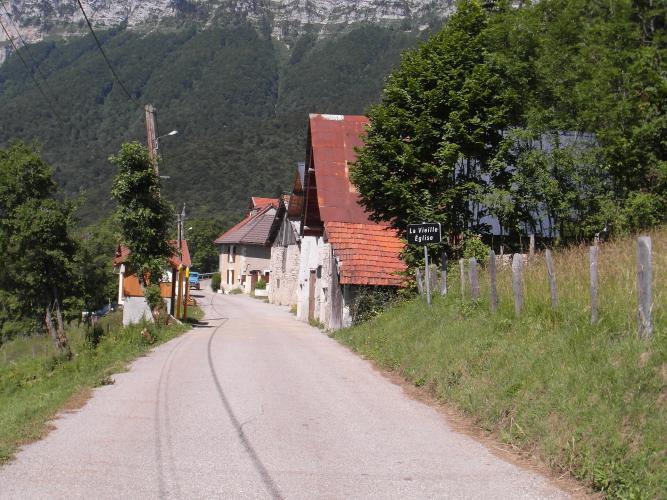
In all it's 8.7 km (5.4 mi) with 691 m (2267 ft) of climbing at 8% - a short climb that hurts like a much longer one. Above the steep section the grade settles to 7 to 10% and the trees start to open. At La Vieille Église, a handful of stone houses and barns under rusty tin roofs, the limestone walls of the Chartreuse suddenly fill the view above you, and behind you the Belledonne fills the skyline across the valley. The last kilometer to Les Prés eases to about 4 to 5%, which feels almost flat by then.
Les Prés is a quiet hamlet of Sainte-Marie-du-Mont, and our route stops there. The D282 keeps going for about 4 km to the Col de Marcieu, where you can drop down the far side through Saint-Bernard-du-Touvet and make a loop of it.
PLAN YOUR ROUTE
 We've partnered with Sherpa-Map.com to bring you the best route planning tool. With a PRO Membership you can use this climb as a reference when creating your route.
The 8.7 km (5.4 mi) climb gains 691 m (2267 ft) at an average of 8%, from 259 m (849 ft) at La Buissière to 948 m (3109 ft) at Les Prés.
The steepest kilometer averages 12.7% (around km 3.9 to 5), the steepest 2 km average 11.5% and the steepest 5 km average 9.4%. Short pitches around km 4 touch 14%.
Km 0 to 2.1: 6.5 to 9.5% up from the valley to about 420 m.
Km 2.1 to 2.5: flat through La Flachère.
Km 2.5 to 3.6: 7.5 to 8.5%.
Km 3.6 to 5.3: the wall - 11 to 14% in the woods, to about 705 m.
Km 5.3 to 7.5: 7 to 11% past La Vieille Église (about 855 m) to about 900 m.
Km 7.5 to 8.7: 4 to 5% to Les Prés.
Roadway: Paved throughout. Above La Flachère the D282 is a narrow mountain road, little more than a lane through the hamlets, with patched tarmac in places - take the steep descent steadily, especially in the woods after rain. The balcony gets snow in winter.
Traffic: Light. The road serves Sainte-Marie-du-Mont's hamlets and the small ski and leisure area at the Col de Marcieu, and riders describe it as quiet. The D1090 at the start is the busier valley road between Grenoble and Chambéry.
Parking: There's no dedicated car park at the start, so park considerately in La Buissière, away from residents' drives. Without a car, Pontcharra station is a few kilometers up the valley, and La Belle Via, the cycle route along the Isère between Grenoble and Chambéry, runs close by.
Gear: Gear for the 2 km at 11 to 14%: a compact with a 32 or 34 at the back, or more if you're carrying any weight. Much of the road is shaded in the morning, but the lower section is exposed, and riders who've done it on a hot summer afternoon say it's brutal, so go early. The descent is steep and twisty, so check your brakes and pads before you start.
Provisions: Bring everything you need from the valley - Pontcharra and Le Touvet have the nearest shops and bakeries, and there's nothing to buy on the climb. If you carry on to the Col de Marcieu, La Renardière there serves lunch with a terrace, but it doesn't open every day outside July and August.
Before heading out on any cycling adventure check out our Things to Bring on a Cycling Trip and use our interactive check list to ensure you don't forget anything.
The Grésivaudan is easy to base yourself in: Grenoble and Chambéry are both within about half an hour by car, Pontcharra has a station on the line between them, and La Belle Via keeps the valley riding between climbs flat and easy.
The best way to use this climb is as the hard first half of a loop along the Balcons de Chartreuse. Carry on from Les Prés to the Col de Marcieu, then drop through Saint-Bernard-du-Touvet to Le Touvet; our Col de Marcieu (Touvet) and Montée de Saint-Bernard-du-Touvet pages cover that side, the Petites Roches plateau and the Château du Touvet. The Isère tourism board's loop goes the other way round, through La Palud and Bellecombe on the D285, with its own steep pitches and a viewpoint by the old château ruins at Bellecombe.
La Vieille Église is also home to beekeepers, so expect bees around the hives in summer. Across the valley, the Station du Barioz climbs make a good second day in the Belledonne.
ROUTE MAP

MEMBER RATING
CURRENT WEATHER
PJAMM TRIPS ADVENTURE STARTER BUNDLES
Check out PJAMM Adventure's prepackaged (self-guided) cycling trips. They will help you plan, document and conquer your next adventure.
NEARBY CLIMBS (0) RADIAL PROXIMITY
FROM No Climbs Found
MEMBER REVIEWS & COMMENTS
Let us know what you thought of this climb. Signup for our FREE membership to write a review or post a comment.
Already have an account?
LOG IN HERE
