30.2
PDI
11.2 mi
DISTANCE
4,491 ft
GAINED
7.4 %
AVG. GRADE
FULL CLIMB STATS
Page Contributor(s): Willem van den Bergh, Netherlands.
INTRO
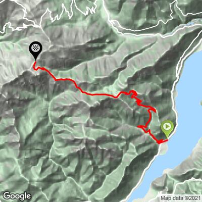
Passo Dosso Alto climbs out of Anfo, a small fortress town on the western shore of Lago d'Idro in the Brescia Prealps, for 11.2 miles at a 7.4% average grade, gaining 4,491 feet to finish at 5,633 feet.
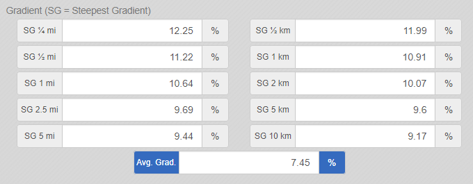
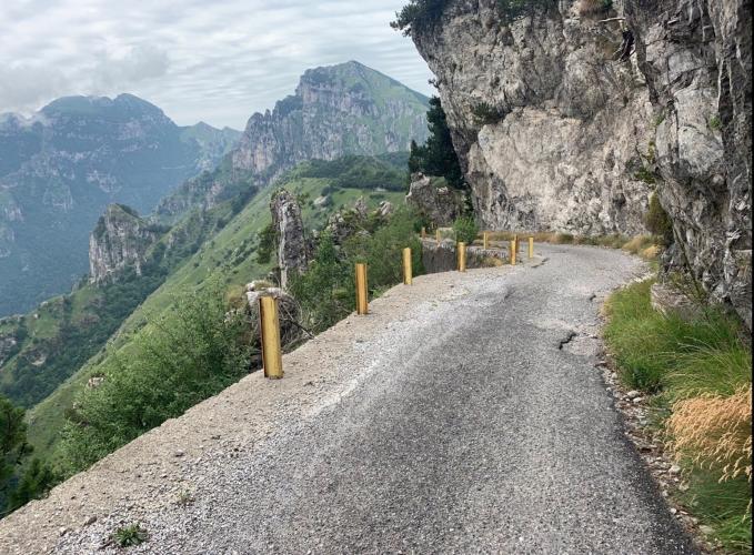
The road is paved and forested for roughly the first 11 kilometers as it climbs to Passo Baremone (1,450m) - a pass locally nicknamed the "Piccolo Stelvio" for its switchbacks and mountain scenery, reached partway through a genuinely dark tunnel (bring a light). Just beyond the pass, the road turns to packed gravel for about a kilometer before reverting to pavement for the final push toward Passo Dosso Alto. The steepest kilometer of the whole climb comes late, beginning around km 16 (roughly 10 miles in) and averaging 10.9%.
This valley has military roots that predate cycling tourism - old trench lines from the First World War still trace parts of the surrounding ridgelines, and Anfo itself sits beneath Rocca d'Anfo, Italy's largest Napoleonic-era fortress, carved into the cliffs above the lake.
The short gravel section is manageable on a road bike for confident riders in dry conditions, per local rider reports, though a gravel or all-road bike is the more comfortable choice - especially on the descent.
PLAN YOUR ROUTE
 We've partnered with Sherpa-Map.com to bring you the best route planning tool. With a PRO Membership you can use this climb as a reference when creating your route.
 This climb averages 7.4% over its 11.2 miles, gaining 4,491 feet from 1,270 feet in Anfo to a finish at 5,633 feet - a steady, sustained effort rather than a series of brutal ramps. The push to Passo Baremone around the 11 km mark runs close to 9% on average, and the steepest kilometer of the entire route comes even later, beginning around km 16 and averaging 10.9%.
Short pitches touch into the low double digits near the top, but nothing on this climb spikes dramatically - it's a long, consistent grind more than a series of shocks.
Roadway: Paved for the first ~11 km through forest and a genuinely dark tunnel (bring a light) to Passo Baremone, then packed dirt and gravel for roughly a kilometer before reverting to pavement for the remaining distance to Passo Dosso Alto. The unpaved section is manageable on a road bike in dry conditions per local riders, though a gravel or all-road setup is the more comfortable choice, especially descending.
Traffic: Light. This is a quiet mountain road connecting Anfo to the Maniva area rather than a major through route, and its remote, forested character keeps casual traffic to a minimum.
Parking: Anfo sits on the western shore of Lago d'Idro; park in the village near the SS237 lakeside road, close to the climb's start on Via S. Petronilla - Map.
There's a mountain hut, Rifugio Baremone, near the halfway point around the pass, but hours are seasonal and not guaranteed, so treat it as a possible stop rather than a sure thing. Beyond the pass, on the gravel section and the final push to Passo Dosso Alto, there's nothing. Anfo itself has basic services as a small lakeside village, so top off water and food there before you start.
Before heading out on any cycling adventure check out our Things to Bring on a Cycling Trip and use our interactive check list to ensure you don't forget anything.
Anfo's centerpiece is Rocca d'Anfo, Italy's largest Napoleonic-era fortress, built into the cliffs above Lago d'Idro on the site of an earlier Venetian outpost. It's worth a look before or after the ride, though touring the interior requires booking a guided visit in advance rather than just walking up. A newer lakeside path connecting Anfo to Ponte Caffaro along the western shore - mostly unpaved - is also worth knowing about if you want an easy spin to cool down after the climb.
Lago d'Idro is one of the quieter lakes in the Italian Prealps compared to Garda or Como, which makes Anfo a low-key, uncrowded base for this ride. Check conditions at both the lake and the summit with our Weather tool before heading out, since the finish sits nearly a mile above the water.
ROUTE MAP
MEMBER RATING
CURRENT WEATHER
PJAMM TRIPS ADVENTURE STARTER BUNDLES
Check out PJAMM Adventure's prepackaged (self-guided) cycling trips. They will help you plan, document and conquer your next adventure.
NEARBY CLIMBS (0) RADIAL PROXIMITY
FROM No Climbs Found
MEMBER REVIEWS & COMMENTS
Let us know what you thought of this climb. Signup for our FREE membership to write a review or post a comment.
Already have an account?
LOG IN HERE