
16.7
PDI
6.1 mi
DISTANCE
2,496 ft
GAINED
7.8 %
AVG. GRADE
FULL CLIMB STATS
INTRO
Col des Mouilles is the kind of climb local riders do on a weekday evening: it starts among the houses of Brignoud on the floor of the Grésivaudan, and within a kilometer you're grinding up hairpins with the valley dropping away behind you. It climbs 9.8 km (6.1 mi) to the col at 1019 m (3,342 ft), gaining 761 m (2,496 ft) at 7.8%, and the hardest of it comes first.
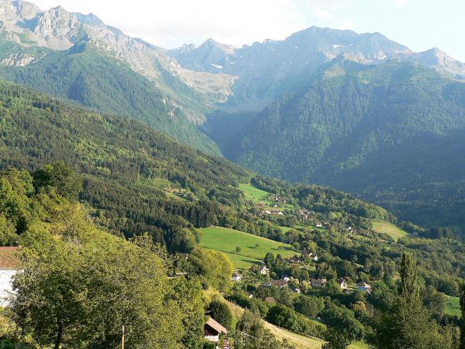
The opening kilometers on the D290 are the steepest, 8 to 11% through the switchbacks above Villard-Bonnot, and the road then squeezes onto a narrow, steep ledge above a ravine on the way to Sainte-Agnès. After that it settles down. The upper road through La Faure runs at 6 to 8.5%, mostly in forest, past meadows and scattered hamlets, with gaps in the trees looking back across the valley to the Chartreuse and up toward the Belledonne peaks.
The col itself is a wooded saddle on the Balcons de Belledonne, the string of hillside roads that runs along the massif above the valley, rather than a big viewpoint - the views come on the way up. From the top you can carry on along the balcony road or drop back to the valley through Saint-Mury, which riders say has the smoother descent of the two.
PLAN YOUR ROUTE
 We've partnered with Sherpa-Map.com to bring you the best route planning tool. With a PRO Membership you can use this climb as a reference when creating your route.
Col des Mouilles averages 7.8% over 9.8 km (6.1 mi), from 258 m (846 ft) in Brignoud to 1019 m (3,342 ft) at the col, and it never goes downhill.
The hardest riding is right at the start. The hairpins out of Brignoud hold the steepest kilometer (10.7%) and the steepest 500 m (11.2%), and kilometers 2 and 3 stay at 9.7% and 9.4% as the road climbs toward Sainte-Agnès. The steepest 2 km average 10.0% and the steepest 5 km 9.0%.
Higher up the grade comes and goes: 7.5% for kilometer 4, 8.6% for kilometer 5, a softer 6.5%, then 7.2% and 8.0% through the forest. The last 1.8 km (1.1 mi) to the col ease to about 6%, so the finish is the easiest part of the climb.
Roadway: Paved to the col. The lower hairpins are on the D290; above them the road narrows, tightest on the ledge before Sainte-Agnès, and the upper half is a minor lane through the forest. Riders have described patched, uneven pavement on this side - enough that some prefer to come down via Saint-Mury instead.
Traffic: Light once you're on the hairpins - mostly residents of Sainte-Agnès and its hamlets. The first few hundred meters run through built-up Brignoud, so that's the only part with town traffic to deal with.
Parking: Brignoud station, on the Grenoble-Chambéry line, is under 2 km (1.2 mi) from the start, so you can come by train from Grenoble and leave the car at home. Driving in, park in the center of Brignoud or Villard-Bonnot rather than on the narrow residential streets where the climb begins.
Provisions: Fill bottles and buy food in Brignoud or Villard-Bonnot before you start. There's a restaurant at the col, but riders have found it shut, so don't plan the ride around it.
Gear: The steep part comes before you're properly warm, so a 34x30 or something close is welcome for the 9-11% kilometers below Sainte-Agnès. The upper road is mostly in the trees and noticeably cooler than the valley, which you'll feel on the descent in spring and autumn.
Before heading out on any cycling adventure check out our Things to Bring on a Cycling Trip and use our interactive check list to ensure you don't forget anything.
Give yourself an hour for the Maison Bergès in Lancey, part of the same commune and about 1.5 km (0.9 mi) from the start. It's the house of Aristide Bergès, the 19th-century engineer who harnessed mountain water to drive his paper mill here, and the museum - formerly the Musée de la Houille blanche - tells that story of the birth of hydroelectric power, along with the family's life and art, including works by Alfons Mucha, who stayed in Lancey several times. Entry is free; it's open Wednesday to Friday afternoons and all day on weekends.
The col links easily with other climbs on this side of the valley: Prapoutel and Pipay start from Froges a few kilometers up the Grésivaudan, and Freydières climbs from Domène toward Grenoble. If you want to string two or three together, the Routes in the Area map shows how the Belledonne balcony roads join up.
ROUTE MAP

MEMBER RATING
CURRENT WEATHER
PJAMM TRIPS ADVENTURE STARTER BUNDLES
Check out PJAMM Adventure's prepackaged (self-guided) cycling trips. They will help you plan, document and conquer your next adventure.
NEARBY CLIMBS (0) RADIAL PROXIMITY
FROM No Climbs Found
MEMBER REVIEWS & COMMENTS
Let us know what you thought of this climb. Signup for our FREE membership to write a review or post a comment.
Already have an account?
LOG IN HERE
