
20.6
PDI
8.2 mi
DISTANCE
3,159 ft
GAINED
7.3 %
AVG. GRADE
FULL CLIMB STATS
INTRO
PLAN YOUR ROUTE
 We've partnered with Sherpa-Map.com to bring you the best route planning tool. With a PRO Membership you can use this climb as a reference when creating your route.
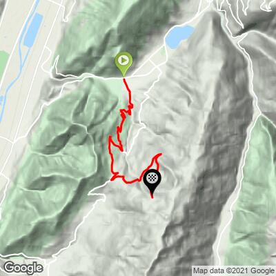
 Station du Barioz gains 963 m (3,159 ft) over 13.1 km (8.2 mi), rising from 483 m (1,585 ft) to 1,440 m (4,725 ft) at the Nordic area, a 7.3% average grade.
The steepest mile averages 8.7%, the steepest kilometer 9.4%, and the steepest half kilometer 11.2%, with the steepest 100 yards reaching 15.8%. The steepest 5 km average 7.9% and the steepest 10 km 7.4%. Riders report the first kilometers above Saint-Pierre as the steepest, with sections over 10%, and the stretch above the col as irregular, with short ramps alternating with easier ground.
Roadway: The road is paved all the way to the Nordic area. Rider reports on the Col du Barioz side vary by year, from correct pavement to patched shaded corners and loose gravel, and above the col the Route des Alpages can be covered in gravel in spring. A 2022 report calls the asphalt very good on the lower section, so expect mixed but rideable conditions and take extra care on the descent.
Traffic: Light. The busy road in this area is the valley route between Goncelin and Allevard, which you leave behind at Saint-Pierre-d'Allevard. The climb itself is a secondary road with some local traffic near the start, and beyond the col it serves little more than the Nordic area and walkers.
Parking: The practical base is Saint-Pierre-d'Allevard, where you can park and ride from the village edge. At the top the asphalt ends at the Espace Nordique du Barioz, where there is a large parking area.
Provisions: The climb runs through forest and farmland with no dependable services on the upper road, so start with full bottles and food. If you want a meal at altitude, the Refuge du Crêt du Poulet (1,700 m / 5,577 ft) is a short walk above the Nordic area; for 2026 it is listed as open every day from 1 June to 30 September.
Gear: Carry a light jacket, since the Nordic area sits about 960 m (3,150 ft) higher than the start. The upper road can hold gravel, twigs and mud, so slightly wider tires are a good idea, particularly in spring and after storms.
Before heading out on any cycling adventure check out our Things to Bring on a Cycling Trip and use our interactive check list to ensure you don't forget anything.
This is the climbing-only version of the Barioz summit, so it fits neatly into a day built around the other two routes. Our Station du Barioz (St. Pierre d'Allevard) page covers the longer approach through Le Cheylas, our Station du Barioz (Tencin) page covers the route up from the Isère valley, and the Refuge du Crêt du Poulet at 1,700 m (5,577 ft) is described on the Saint-Pierre-d'Allevard page.
For information, the Belledonne Chartreuse tourist office has its main office at 11 place de la Résistance in Allevard-les-Bains (+33 4 76 45 10 11). The Col du Barioz, about 8 km (5 mi) up this climb, links to Theys by the Route des Balcons de Belledonne if you want to vary the descent. For other climbs nearby, including Le Collet d'Allevard and Dôme des Oudis, try our Routes in the Area tool.
ROUTE MAP
MEMBER RATING
CURRENT WEATHER
PJAMM TRIPS ADVENTURE STARTER BUNDLES
Check out PJAMM Adventure's prepackaged (self-guided) cycling trips. They will help you plan, document and conquer your next adventure.
NEARBY CLIMBS (0) RADIAL PROXIMITY
FROM No Climbs Found
MEMBER REVIEWS & COMMENTS
Let us know what you thought of this climb. Signup for our FREE membership to write a review or post a comment.
Already have an account?
LOG IN HERE
