Montebello Road Bike Climb - PJAMM Cycling

4.5
FIETS
5.2 mi
DISTANCE
2,041 ft
GAINED
7.3 %
AVG. GRADE

FULL CLIMB STATS

INTRO

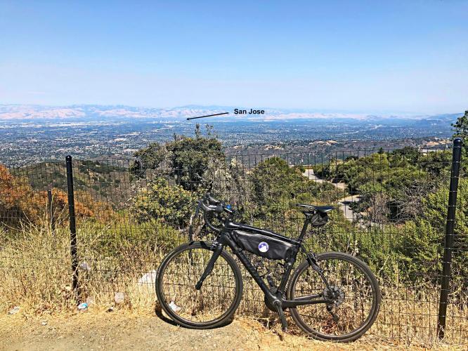
This climb begins at the western tip of Stevens Creek Reservoir. The first 1.5 miles greet us with nearly double digit average grade. Thereafter, the climb is much more comfortable and gives us some great views to the east of Mt. Hamilton, Moffett Field giant dirigible hangers, Mt. Diablo, and the Silicon Valley in general.
The average grade on this climb is 7.3% (7.7% if we removed all but ascent from the gradient formula).  Most of the climb is at 5-10% (56%/2.9 miles), but 15% (0.8) miles is at 10-15% and a 4.1% (0.2) mile sliver is in the 15-20% range.  The climb never goes above 20%.  The steepest quarter-mile is 12.3% and there is a continuous half-mile segment at 10.6%

See more details and tools regarding this climb's grade via the “Profile Tool” button.
Roadway:  Good the entire climb.  The first two miles of the climb are on a divided two-lane roadway, while the final three miles are on two lanes with no center stripe.

Traffic:  Minimal.

Parking:  Park at the Stevens Creek Reservoir about a half mile east of the climb start - MapStreet View
Provisions:  There are no provisions on this climb, although you can wine taste. 😊  Google Map - Wineries on Montebello Road.
Before heading out on any cycling adventure check out our Things to Bring on a Cycling Trip and use our interactive check list to ensure you don't forget anything.
See PJAMM's Santa Clara County climb page for other climbs in the area.  When traveling to the Santa Clara County to cycle, you might choose to stay in Saratoga or Santa Cruz. There are also great options for house rentals in the area.
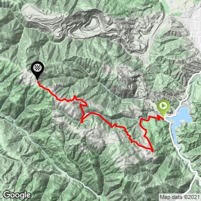
ROUTE MAP

MEMBER RATING

Difficulty: Challenging
3.5
Road
4
Traffic
4
Scenery

CURRENT WEATHER

PJAMM TRIPS ADVENTURE STARTER BUNDLES

Check out PJAMM Adventure's prepackaged (self-guided) cycling trips. They will help you plan, document and conquer your next adventure.
ALL TRIPS
Browse all of our prepackaged trips and find your next adventure!
Sonoma County
United States (CA)
19 ROUTES
39 POIs
ROUTE STATS (TOTAL)
269.3
mi
DISTANCE
41,801
ft
ELEV. GAIN

NEARBY CLIMBS (0) RADIAL PROXIMITY

FROM
No Climbs Found

MEMBER REVIEWS & COMMENTS

Let us know what you thought of this climb. Signup for our FREE membership to write a review or post a comment.
Already have an account?

Jul 27, 2023
difficulty: Challenging
scenery: 4
traffic: 4
road: 4
Jul 27, 2023
scenery: 4
traffic: 4
road: 4
starts out pretty hard the first 2 miles, then eases up and it gets much easier. continue past the gate at the end of this segment to ride on the gravel part of montebello road, which you can take to pagemill to loop back thru foothill
Dec 29, 2021
difficulty: Challenging
scenery: 4
traffic: 4
road: 3
Dec 29, 2021
scenery: 4
traffic: 4
road: 3
The bottom is pretty steep until you reach the school. It eases off for a very brief moment when you pass the school and gradually gets steeper and steeper until you reach Swiss creek lane. That’s when the real climbing starts up again. Not as difficult as the bottom but it doesn’t get much easier until your basically at the top. Right before the end you’ll be faced with pretty steep wall and another not so steep one right behind it. Beyond those two bumps is relatively flat smooth sailing to the end of the paved section.
ROUTE MAP
PROFILE TOOL
Route Data
S.G. (%)
hide
Segment Data
hide

Climb Profile Not Found
CLIMB SUMMARY

Cycling Montebello, Santa Cruz Mountains, California  - sharp hairpin turn along a two-lane paved road looking out over vineyards

Cycling Montebello Road

Ride 5.2 miles gaining 2,036’ at 7.3% average grade.

Climb summary by PJAMM’s John Johnson.

Cycling Montebello, Santa Cruz Mountains, California - photo collage, PJAMM Cycling logo in corner, cyclist riding in street with family of geese crossing in front of him, road bike parked along fence line on hillside overlooking Silicon Valley, cyclist riding uphill along roadway next to road sign noting no parking on Montebello Road, bike parked against  Midpeninsula Regional Open Space sign for Picchetti Ranch,

This climb  begins at the western tip of Stevens Creek Reservoir in the Santa Cruz Mountains near Cupertino, California.  The first 1.5 miles greet us with nearly double digit average grade.  Thereafter, the climb is much more comfortable and gives us some great views to the east of Mt. Hamilton, Moffett Field giant dirigible hangars, Mt. Diablo, and generally the Silicon Valley.

Before heading to California on your cycling adventure, be sure to rely on our list of Things to Bring on a Cycling Trip, and use our interactive checklist to ensure you don't forget anything.

Cycling Montebello, Santa Cruz Mountains, California - photo collage, PJAMM Cycling logo in corner, road signs for Montebello Road, Not A Through Road, views along stretches of straight roadway

Start: Ride up Montebello Road from its T intersection with Stevens Canyon Road.

Who would have known that just a few miles west of Cupertino, CA and the Silicon Valley, we are in Wine Country!  There are several vineyards/wineries clearly visible as we climb into the Santa Cruz Mountains Appellation.  

Cycling Montebello, Santa Cruz Mountains, California - bike parked against sign on side of roadway for Wine Trail

Cycling Montebello, Santa Cruz Mountains, California - photo collage, PJAMM Cycling logo in corner, bike parked on roadside against sign for Winery, Ridge Vineyards, and Rebels Ranch, stack of three wine barrels, bike parked against various fences in front of wineries
Views along the climb.

Cycling Montebello, Santa Cruz Mountains, California - road bike parked in brush along hillside overlooking Silicon Valley and Moffett Field

Moffett Field to the northeast.

Photos:  

Top Left:  PICRYL Collections

Top Right and Bottom:  Wikipedia

We have amazing views of the Silicon Valley and South Bay along this climb, including the retired Naval Air Base, Moffett Field. Moffett Field is home to some of the largest freestanding buildings in the world (old dirigible Hanger 1 covers eight acres).  I have fond memories of Moffett Field, having flown into it from Midway Island when I was stationed there (1976-1977) and serving as a Naval Judge Advocate General Corps during breaks from Santa Clara Law School (1981-1984).

Hanger One’s history:

“Built in 1931-1932, designed by German airship engineer Dr. Karl Arnstein for the Goodyear Zeppelin Corporation, Hangar One covers 8 acres and can accommodate six American football fields.

It measures 1,133 feet (345 m) long and 308 feet (94 m) wide and 198 feet (60 m) high. The hangar's interior is so large that fog sometimes forms near the ceiling. The "orange peel" doors, weighing 200 short tons (180 metric tons) each, are moved by their own 150 horsepower (110 kW) motors.

At the time this was built, it was the largest building in the world without interior supports, providing an unusually extensive room for the construction of "lighter-than-air" airships. It was significant for U.S. Navy coastal defense capabilities during the peacetime era between 1932 and 1941 and construction of USS Akron and its sister ship, USS Macon, built in 1931 and 1933. These two airships were 785 feet (239 m) in length” (read more here).

Cycling Montebello, Santa Cruz Mountains, California - bike parked in greenery along hillside overlooking Silicon Valley and San Jose

San Jose to the east.

Cycling Montebello, Santa Cruz Mountains, California - View from hillside looking out over Stevens Crrek Reservoir and Mt. Hamilton

Stevens Creek Reservoir with Mt. Hamilton in background center left.

Cycling Montebello, Santa Cruz Mountains, California - view along hillside overlooking Mt. Diablo

Mt. Diablo 40 miles northeast.

Cycling Montebello, Santa Cruz Mountains, California - photo collage, PJAMM Cycling logo in corner, bike parked in front of: Share the Road road sign, fence in front of old rusted farm truck, white fence along roadside, gate in front of sign that says JIMSOMARE, Pichetti Winery, Road Narrows road sign, and along side of curved stretch of road

More views along the ride.

 Cycling Montebello, Santa Cruz Mountains, California - stretch of curved two-lane road going up hillside with road sign noting to Share The Road

Bike Friendly.

Roadway Surface and Traffic Report:  The road is in fairly good shape and is two lanes for the first two miles, narrowing to one lane for the last three.  There is very little traffic along the route, it ends at a dead-end and is considered very safe and enjoyable.