
31.4
PDI
10.1 mi
DISTANCE
4,386 ft
GAINED
8.2 %
AVG. GRADE
FULL CLIMB STATS
INTRO
Val Pelouse climbs 10.1 miles from Valgelon-La Rochette, in the Belledonne massif of Savoie, France, to the site of a long-abandoned ski station at roughly 5,550 feet, gaining 4,386 feet at an 8.2% average grade. It's one of the toughest, least-known climbs in the department - genuinely comparable in difficulty to the famous Mont du Chat above Le Bourget-du-Lac, but with almost none of the traffic or reputation.
The road eases you in - the first four kilometers to Arvillard average around 5% - before turning hard onto the D208 and climbing almost without a break through dense forest, with a brutal middle third between roughly the 6th and 11th kilometers that holds 9-13% for long stretches. There's little view for most of the way; the trees only open up in the final few kilometers, where the grade calms slightly to a still-tough 8-9% into the finish.
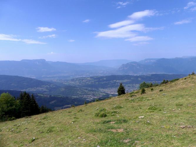
Val Pelouse was a real ski resort once - built in 1969 with nine runs and five lifts, it never solved a hard-to-plow access road, a lack of nearby lodging, and stiff competition from bigger Belledonne resorts, and closed for good on August 5, 1986, carrying over 5 million francs in debt. The old base area is largely gone, but the wide summit parking lot survives along with a wooden "Décollage de Val Pelouse" sign - it's since become a popular paragliding launch point, with views over the Chartreuse massif, the Dent de Crolles, and the Bauges.
Pavement is patchy in the upper half, with cracks and the occasional pothole - more of a concern on the descent than on the way up. Because the road genuinely doesn't lead anywhere beyond the old ski station, traffic is close to nonexistent past Arvillard. Check current conditions with our Weather tool before heading up, since the summit sits well above 5,000 feet in an exposed alpine bowl.
PLAN YOUR ROUTE
 We've partnered with Sherpa-Map.com to bring you the best route planning tool. With a PRO Membership you can use this climb as a reference when creating your route.
 Val Pelouse's 8.2% average over 10.1 miles hides one of the more front-loaded grade profiles in the Alps. The first four kilometers into Arvillard are a genuine warm-up at 5% or under, before the road tips up hard - the steepest kilometer comes in at 11.8%, and the steepest mile still holds 10.5%. There are a couple of very sharp pitches too, with the steepest quarter mile at 12.9% and a brief ramp reaching 17.9% over 100 yards. The final few kilometers ease only slightly, settling into a still-demanding 8-9% to the finish.
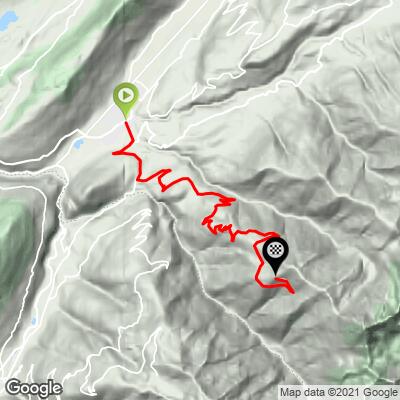
Roadway: The road is paved throughout - the D209 through Arvillard, then the D208 the rest of the way - but conditions deteriorate noticeably above Arvillard. Recent rider reports describe cracked, uneven pavement and occasional potholes on the D208, especially in its upper reaches, so ride the descent with more caution than the climb. The road sees little traffic and correspondingly little maintenance, since it no longer leads anywhere beyond the old ski station's parking lot.
Traffic: Traffic is light even through Arvillard and drops to almost nothing above the village - this is a dead-end road serving only a handful of hamlets and the closed ski station, so you'll likely have the upper two-thirds of the climb to yourself.
Parking: There's no need to park before starting - the climb begins right in the center of Valgelon-La Rochette at Place Joseph Dijoud, near the town's tourist office, with ample street parking nearby. Those who'd rather drive partway can find roadside parking in Arvillard, at the base of the steeper D208 section.
Valgelon-La Rochette has shops, bakeries, and cafes at the start for a pre-ride stock-up. Arvillard, about 4 kilometers in, is the last real village with services - there's little to nothing above it, and the old Val Pelouse ski station at the top has no operating facilities, so carry all the water and food you'll need for the full climb.
Before heading out on any cycling adventure check out our Things to Bring on a Cycling Trip and use our interactive check list to ensure you don't forget anything.
Val Pelouse pairs naturally with the other Belledonne climbs radiating out from the La Rochette area - Col de Champlaurent, Col du Grand Cucheron, and Le Collet d'Allevard are all a short drive away - so it's worth basing in Valgelon-La Rochette or nearby Allevard for a multi-day mix of these lesser-known Savoie ascents.
There's no cafe or shop at the summit, so plan to refuel back down in Arvillard or La Rochette rather than at the top. If you have time once you're up there, it's worth walking a few minutes past the parking lot to the paragliding launch point for the view over the Chartreuse and Bauges massifs.
ROUTE MAP
MEMBER RATING
CURRENT WEATHER
PJAMM TRIPS ADVENTURE STARTER BUNDLES
Check out PJAMM Adventure's prepackaged (self-guided) cycling trips. They will help you plan, document and conquer your next adventure.
NEARBY CLIMBS (0) RADIAL PROXIMITY
FROM No Climbs Found
MEMBER REVIEWS & COMMENTS
Let us know what you thought of this climb. Signup for our FREE membership to write a review or post a comment.
Already have an account?
LOG IN HERE
