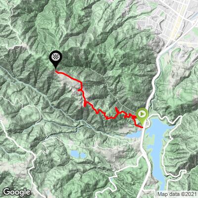
12.1
PDI
3.6 mi
DISTANCE
1,653 ft
GAINED
8.9 %
AVG. GRADE
FULL CLIMB STATS
INTRO
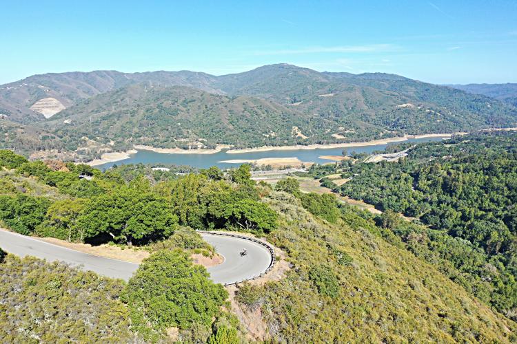
This one is no slouch! Among the several great climbs in the Lexington Reservoir area, Montevina is the only one that gives us some very nice distant views.
PLAN YOUR ROUTE
9.1% average grade - 46% of the climb is at 5-10%, 33% is at 10-15%, 3% is at 15-20%, and at the end there is a brief pitch at 20%. The steepest quarter-mile is 15.7%.
See more details and tools regarding this climb's grade via the “Profile Tool” button.
Roadway: Paved the entire climb, narrow with no center stripe and good condition.
Traffic: Minimal.
Parking: At the start of the Black Road climb 3/10ths of a mile from the start of this climb - Map; Street View.
Information Not Available
If you have any information regarding this climb, we'd like to hear from you. Click the CONTRIBUTE button to share your thoughts with us.
Before heading out on any cycling adventure check out our Things to Bring on a Cycling Trip and use our interactive check list to ensure you don't forget anything.
There are several great Santa Clara County and Santa Cruz County climbs in the area. Use the “Routes in Area” button to see other bike climbs in this area.
You can stay in nearby Los Gatos to tackle this climb. If you are looking to spend several days in the area you can look to rent a house for your cycling adventure.
ROUTE MAP
MEMBER RATING
CURRENT WEATHER
PJAMM TRIPS ADVENTURE STARTER BUNDLES
Check out PJAMM Adventure's prepackaged (self-guided) cycling trips. They will help you plan, document and conquer your next adventure.
NEARBY CLIMBS (0) RADIAL PROXIMITY
FROM No Climbs Found
MEMBER REVIEWS & COMMENTS
Let us know what you thought of this climb. Signup for our FREE membership to write a review or post a comment.
Already have an account?
LOG IN HERE
veerravuri
Very nice climb out of los gatos. It dead ends for cars but a gravel (doable on 25mm clinchers) road extends for 2 miles and connects to bohlman, which descends close to 9. Overall the grade is very consistent, but most of this road is exposed so it can get very hot.