
17.1
PDI
6.5 mi
DISTANCE
2,586 ft
GAINED
7.6 %
AVG. GRADE
FULL CLIMB STATS
INTRO
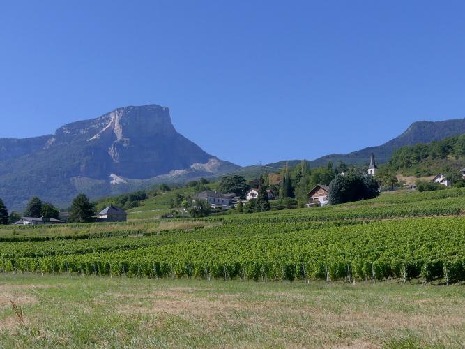
The vines you ride through at the start of this climb grow on what's left of a mountain. On the night of 24 November 1248 part of Mont Granier's limestone face collapsed onto the plain below, burying five villages, and the stony debris became the vineyards of Apremont - home of pale, mineral Jacquère whites. The road to the Col du Granier heads straight up through those vines toward the cliff that caused it all.
It's 10.4 km (6.5 mi) at 7.6%, gaining 788 m (2586 ft), and it starts hard - riders call the opening steep and fast, and the grade barely drops below 7% for the first 8 km. The steepest kilometer, at 9.5%, comes around La Torne as the road leaves the last houses for the forest. At about 8 km you join the D912 coming up from Chambéry by the Pas de la Fosse, and the last 2.4 km are noticeably easier.
This is the quiet way up the Granier. Riders describe the lower road as very peaceful - one saw wild boar about 3 km from the top - and you'll often have the forest hairpins to yourself until the D912. The col has been on the Tour de France route 17 times since 1947, most recently in 2012, and the 2025 Tour de France Femmes crossed it on the stage into Chambéry.
PLAN YOUR ROUTE
 We've partnered with Sherpa-Map.com to bring you the best route planning tool. With a PRO Membership you can use this climb as a reference when creating your route.
The climb gains 788 m (2586 ft) in 10.4 km (6.5 mi), a 7.6% average, rising from 339 m (1113 ft) to 1127 m (3698 ft) on our GPX - just below the signed 1134 m at the col.
There's no warm-up: the first kilometer is already at 7%, and from there to 8 km (5.0 mi) the road holds 7-9.7% with only brief let-ups. The steepest half-kilometer reaches 10.7%, the steepest kilometer 9.5% (around 3.5-4.5 km, 2.2-2.8 mi) and the hardest 5 km (3.1 mi) average 8.4%.
Once you join the D912 at about 8 km the grade relaxes to 5-7%, averaging about 6% over the final 2.4 km (1.5 mi) to the col.
Roadway: It's sealed road the whole way. The lower part is the Route du Col du Granier, a narrow road that winds up through the vineyards and the hamlets of Le Devin and La Torne before entering the forest; riders rate the surface good to fair. From about 8 km you're on the D912, the main road over the col between Chambéry and the Entremont valley, which is wider and smoother. The Savoie department posts closures and roadworks on the D912 on savoie.fr - recent ones have mostly been on the Chambéry approach at Montagnole rather than this side.
Traffic: Light on the Apremont road, where you'll mostly meet vineyard vehicles and residents. The last 2.4 km on the D912 carry the through traffic between Chambéry and the Chartreuse, busier on weekends.
Parking: There's no dedicated car park at the start (Street View), so park considerately in Apremont village, a short way up the road, and keep vineyard tracks clear - they're working roads, especially during the harvest. Chambéry, the nearest rail hub, is a short ride to the north.
Gear: This is a sustained effort rather than a wall: 7-9% for 8 km with nothing much above 10%. Pick a gear you can hold for 45 minutes or more, and warm up on the flat roads below the vineyards first, because the climb doesn't give you a gentle start.
Provisions: Bring what you need from Chambéry or the villages below. There's a restaurant with a large terrace at the col, the Restaurant du Col du Granier; its listed hours are long, but check before relying on it out of season. The forest gives good shade on the upper half.
Before heading out on any cycling adventure check out our Things to Bring on a Cycling Trip and use our interactive check list to ensure you don't forget anything.
Apremont is wine country first, and a glass of the local Jacquère with the Granier in front of you is a fine way to end the ride. Chambéry, a short ride north, is the place to stay, with the château of the Dukes of Savoy and the Fontaine des Éléphants in its old town.
The Granier has five routes up in our database: this one, Chapareillan (the steepest, with the history of the 1248 collapse on its page), Chambéry, Saint-Baldoph and Saint-Pierre-d'Entremont. From the col you can drop into the Entremont valley toward the Col du Cucheron and the Col de Porte, the rest of the classic Chartreuse crossing.
For a shorter loop, come down the D912 by the Pas de la Fosse toward Chambéry - the gentlest way off the mountain - and roll back through the vineyards to Apremont.
ROUTE MAP

MEMBER RATING
CURRENT WEATHER
PJAMM TRIPS ADVENTURE STARTER BUNDLES
Check out PJAMM Adventure's prepackaged (self-guided) cycling trips. They will help you plan, document and conquer your next adventure.
NEARBY CLIMBS (0) RADIAL PROXIMITY
FROM No Climbs Found
MEMBER REVIEWS & COMMENTS
Let us know what you thought of this climb. Signup for our FREE membership to write a review or post a comment.
Already have an account?
LOG IN HERE
