
16.3
PDI
7.6 mi
DISTANCE
2,699 ft
GAINED
6.7 %
AVG. GRADE
FULL CLIMB STATS
INTRO
This is the Granier for riders who find the Chambéry road too gentle. It starts among the houses on the edge of town, stays off the main road for its first 7 km, and does most of its climbing on a steep, quiet lane - riders who've done both say it's harder than the Chambéry side, with fewer cars, until the two roads meet. From Saint-Baldoph to the col at 1134 m (3720 ft) it's 12.3 km (7.6 mi) at 6.7%, gaining 823 m (2699 ft).
A short, sharp ramp gets you out of the village, then the first couple of kilometers barely climb as the road threads through the hamlets above Saint-Baldoph - about a third of the ride is residential. Then the D72A Route de Chartreuse turns up the hill and stays there. From km 2 to km 7 it averages close to 9%, with the steepest kilometer at 11.8% around La Grande Montagne, and the views open up behind you over the Chambéry valley as you go.
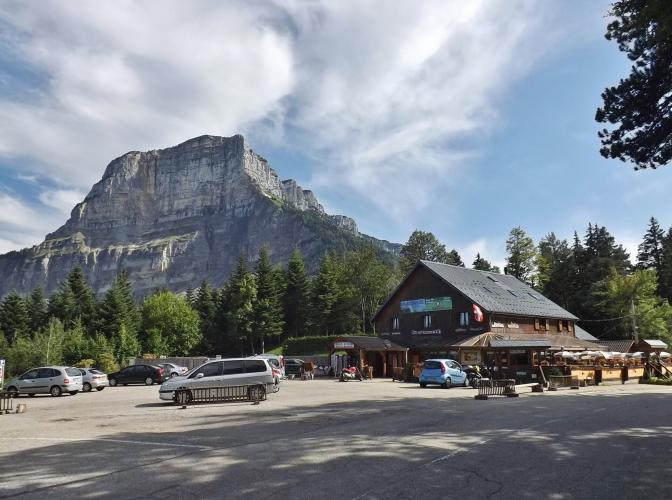
Near Le Sevret, at about km 7, you come out on the D912 from Chambéry and the character changes completely: the next 1.5 km are nearly flat, and the last 3.7 km climb through forest at a steady 5 to 7.7%, with the road from Apremont joining 2.4 km from the top. At the col there's a restaurant terrace under the limestone face of Mont Granier, the cliff that collapsed in 1248 - our Apremont and Chapareillan pages tell that story.
PLAN YOUR ROUTE
 We've partnered with Sherpa-Map.com to bring you the best route planning tool. With a PRO Membership you can use this climb as a reference when creating your route.
Almost all of the hard climbing is between km 2 and km 7. Out of Saint-Baldoph there's a ramp of 8.5% (km 0.5 to 1), then km 1 to 2 is nearly flat at 2 to 3% through Le Mollard.
From km 2 to 7 the D72A averages 8.9%: 8.5% at km 2, 9 to 9.7% from km 3 to 4.5, a short easing to about 5% around km 4.5, then 10.7%, 9.8% and 11.7% between km 5 and 6.5. The steepest kilometer averages 11.8%, the steepest 2 km 10.2% and the steepest 5 km 9%, and there are short pitches above 12% inside that stretch.
After the D912 junction, km 7 to 8.5 gains only about 25 m. The final 3.7 km to the col average about 7%, between 4.5 and 7.7%.
Roadway: Sealed throughout. The lanes through Saint-Baldoph's hamlets and the D72A are narrow, and the surface on this side is fair rather than smooth - one rider found the top of the D72A rough and cracked on the way down. That descent is steep and twisty, so take it slowly. The D912 between Chambéry and the col gets short daytime works restrictions a few times a year - the Savoie department posts them on savoie.fr - and the col can hold snow in winter.
Traffic: Light on the Saint-Baldoph roads, mostly residents. From km 7 you share the D912 with traffic between Chambéry and the Chartreuse, busier on weekends. Riders rate this side quieter than the main road, though there's at least one report of a dangerously close pass.
Parking: The Centre Socioculturel du Pré Martin car park in Saint-Baldoph, where local walking routes start, is a short roll from the start (Street View just above it). Without a car, Chambéry buses 3, 4 and 5 run to the Saint-Baldoph Centre stop, and it's an easy ride out from Chambéry station.
Gear: Gear it for km 2 to 7, which sit near 9% with pitches past 12% - a 34x32 is not too much. The brakes do real work on the D72A coming back down.
Provisions: Saint-Baldoph has shops around the roundabout in the village center; fill up there, because there's nothing until the col. The Restaurant du Col du Granier at the top has a large terrace, but check its hours outside summer.
Before heading out on any cycling adventure check out our Things to Bring on a Cycling Trip and use our interactive check list to ensure you don't forget anything.
Saint-Baldoph is practically part of Chambéry, so stay in town - our Apremont page has the old-town highlights. For a short loop, climb this side and come down the D912 to the Apremont turnoff 2.4 km below the col, then drop through the Apremont vineyards back toward Saint-Baldoph. Or carry on over the col into the Entremont valley for the Col du Cucheron and the Col de Porte.
If you have a spare morning, the Croix de la Coche walk leaves from the Pré Martin car park and climbs through vineyards and woods to a stone cross on the ridge above the village, with views from the Chartreuse to the Bauges. It's about 8 km and 3h30, with a narrow ridge path, so wear proper shoes.
ROUTE MAP

MEMBER RATING
CURRENT WEATHER
PJAMM TRIPS ADVENTURE STARTER BUNDLES
Check out PJAMM Adventure's prepackaged (self-guided) cycling trips. They will help you plan, document and conquer your next adventure.
NEARBY CLIMBS (0) RADIAL PROXIMITY
FROM No Climbs Found
MEMBER REVIEWS & COMMENTS
Let us know what you thought of this climb. Signup for our FREE membership to write a review or post a comment.
Already have an account?
LOG IN HERE
