
16.1
PDI
7.1 mi
DISTANCE
2,615 ft
GAINED
6.8 %
AVG. GRADE
FULL CLIMB STATS
INTRO
PLAN YOUR ROUTE
 We've partnered with Sherpa-Map.com to bring you the best route planning tool. With a PRO Membership you can use this climb as a reference when creating your route.
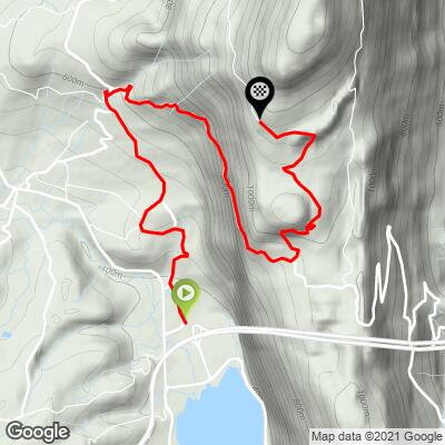
Overall: 11.5 km (7.1 mi) from 382 m (1254 ft) to 1157 m (3795 ft), gaining 797 m (2615 ft) at an average of 6.8%.
The shape: 4 km at 5.1% through the villages, 5 km (3.1 mi) at 8.8% up the D916 and onto the forest road, then 2.5 km at 5.3% across the plateau.
Kilometer by kilometer: 6.2%, 4.2%, 4.5%, 5.5%, 9%, 9.1%, 8%, 9.5%, 8.3%, 5%, 6.8%, and 2.8% for the final 0.5 km.
Steepest sections: 0.5 km at 12.2%, 1 km at 11%, 2 km at 9.7%, 5 km at 9%.
Roadway: Paved to the finish. The D916 is a two-lane road in good shape. The Route forestière de Belledigue is a narrow, single-track forest road - asphalt, but thin and patched, with leaves, needles and the odd fallen branch on it in autumn - so take the descent slowly and expect cars coming the other way on blind bends. At over 1100 m the plateau can hold snow in winter.
Traffic: The D916 is the road between the lake and Chambéry over the Col de l'Épine, so expect regular local traffic on the middle section. The forest road is quiet - mostly walkers driving up to the car park, busiest on fine weekends.
Parking: Park in Nances near the start, or by the lake and ride up. The gravel car park at the top is for walkers and fills up on good weekends, so don't plan on driving up to ride down.
Gear: A compact with a 30 or 32 covers the 9-12% stretch either side of the forest-road turn. Tires of 28 mm or wider make the patched forest road, and the descent on it, a lot more comfortable.
Provisions: There's no water or food on the climb or at the top. Fill bottles and buy what you need around the lake or in Chambéry before you set off.
Before heading out on any cycling adventure check out our Things to Bring on a Cycling Trip and use our interactive check list to ensure you don't forget anything.
Lac d'Aiguebelette is the reason to be here. It's a private lake, owned by EDF and the de Chambost family, and petrol engines are banned, so the water is quiet and clean - the World Rowing Championships were held on it in 2015. Swimming is from beaches that charge entry in summer, including Sougey, Lépin-le-Lac and Pré-Argent at Novalaise.
The same ridge has more climbing. The Col de l'Épine itself drops east to Chambéry, and the Mont du Chat rises on the ridge further north, above the Lac du Bourget - see our Mont du Chat - Meyrieux and Mont du Chat - Le Bourget-du-Lac pages. South of Chambéry, our Rocher du Corbeley page covers a steep one into the Chartreuse.
ROUTE MAP
MEMBER RATING
CURRENT WEATHER
PJAMM TRIPS ADVENTURE STARTER BUNDLES
Check out PJAMM Adventure's prepackaged (self-guided) cycling trips. They will help you plan, document and conquer your next adventure.
NEARBY CLIMBS (0) RADIAL PROXIMITY
FROM No Climbs Found
MEMBER REVIEWS & COMMENTS
Let us know what you thought of this climb. Signup for our FREE membership to write a review or post a comment.
Already have an account?
LOG IN HERE
