
21.9
PDI
11.8 mi
DISTANCE
3,800 ft
GAINED
6.1 %
AVG. GRADE
FULL CLIMB STATS
INTRO
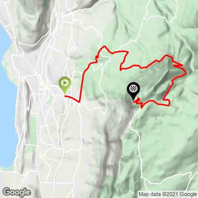
The Route du Revard is the classic climb from the Aix-les-Bains basin up to the Revard plateau in the Bauges massif: 19.0 km (11.8 mi) from the hillside village of Mouxy at 372 m (1,219 ft) to 1,523 m (4,997 ft), gaining 1,158 m (3,800 ft) at a 6.1% average. It follows the D913 through Pugny-Chatenod, Trévignin and Montcel. The difficulty is the length rather than any single wall - the steepest kilometer averages 8.4% - so expect a long, steady effort, much of it in forest.
This is climbing history too: Stage 15 of the 1972 Tour de France ran 28 km from Aix-les-Bains to Le Revard, and Cyrille Guimard beat Eddy Merckx to the line by the narrowest of margins. The ski station at the top dates to 1908 and is often described as the first in France.
Important for now: after a landslide in February 2026, the Savoie department is repairing the D913 at Montcel. The road is closed to vehicles, cyclists and pedestrians in the work zone, day and night, from 28 September through the end of October 2026, with a signed 42 km (26 mi) detour via Lescheraines and La Féclaz. Check status before you ride.
PLAN YOUR ROUTE
 We've partnered with Sherpa-Map.com to bring you the best route planning tool. With a PRO Membership you can use this climb as a reference when creating your route.
 The Route du Revard averages 6.1% over 19.0 km (11.8 mi), and that modest figure is accurate - this is a climb of steady effort rather than ramps. The steepest half kilometer (0.3 mi) averages 8.8%, the steepest full kilometer (0.6 mi) 8.4%, and the steepest 2 km (1.2 mi) 7.8%. Zoom out and the gradient stays consistent: the steepest 5 km (3.1 mi) averages 7.4% and the steepest 10 km (6.2 mi) 7.1%, and even the steepest 100 yards (91 m) tops out at only 9.2%.
Riders describe long forested stretches at a fairly even 5-8%, with one stiffer kilometer around the hamlet of Véniper at about 8.5% and relatively few hairpins. Because nothing is truly steep, the trap is pacing: start easy and let the top third do its work.
Roadway: The climb follows the Route du Revard (D913), a paved secondary road, and riders describe the surface as generally well maintained with a few rougher sections. A landslide at Montcel in February 2026 damaged the road, and traffic has run under alternating one-way flow since. The Savoie department is now repairing it, with the road fully closed to vehicles, cyclists and pedestrians in the work zone from 28 September through the end of October 2026 (the signed detour is 42 km / 26 mi via Grésy-sur-Aix, Cusy, Lescheraines, Le Noyer, Plainpalais and La Féclaz). Confirm it has reopened before you go.
Traffic: Busiest near Aix-les-Bains and Mouxy, then thinning out steadily as the road climbs into the forest. It is also the main access route to the Revard ski area, so expect more cars on winter weekends and fine summer days.
Parking: Mouxy is a hillside village of about 2,300 residents above Aix-les-Bains, with no dedicated cycling car park. Most published profiles start in Aix-les-Bains itself, which adds about 2.5-3 km (1.6-1.9 mi) to reach Mouxy, and Aix has a railway station (on two lines, with about 1.9 million passengers in 2024) if you would rather arrive by train.
Bring two bottles and some food for a climb of this length, though riders report a water fountain roughly 8 km (5 mi) below the top. The summit plateau sits at about 1,523 m (4,997 ft), more than 1,100 m (3,600 ft) above the start, so it can be much cooler and windier than the valley, and the long descent chills you quickly - pack a windproof layer even in summer. With no ramp above about 9%, a standard compact drivetrain is plenty.
Before heading out on any cycling adventure check out our Things to Bring on a Cycling Trip and use our interactive check list to ensure you don't forget anything.
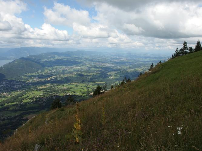
The reward at the top is one of the best viewpoints in the region: a belvédère with glass barriers looking out over Lac du Bourget, Aix-les-Bains and, on a clear day, Mont Blanc. The Revard plateau sits inside the Bauges regional nature park on a limestone plateau riddled with caves - the Garde-Cavale system alone has more than 50 km (31 mi) of explored passages - and it is a ski area in winter, so this is a climb worth timing for a clear day.
For the way down, you can return by the same road, drop toward Chambéry, or continue into the Bauges via La Féclaz and Lescheraines, the direction the current road-closure detour follows. Lac du Bourget, Aix-les-Bains and the Abbaye de Hautecombe are covered on our Mont du Chat - Le Bourget-du-Lac page, so use this trip to explore the plateau instead. Check current conditions at the base and the top with our Weather tool before you go.
ROUTE MAP
MEMBER RATING
CURRENT WEATHER
PJAMM TRIPS ADVENTURE STARTER BUNDLES
Check out PJAMM Adventure's prepackaged (self-guided) cycling trips. They will help you plan, document and conquer your next adventure.
NEARBY CLIMBS (0) RADIAL PROXIMITY
FROM No Climbs Found
MEMBER REVIEWS & COMMENTS
Let us know what you thought of this climb. Signup for our FREE membership to write a review or post a comment.
Already have an account?
LOG IN HERE
carlinguernsey
This is a tough test right out of the center of Aix les Bains. The gradient is mostly 5% to 7% with some harder sections, but the length takes its toll. The lower part is mostly villages and farmland, and the higher part is mostly forest. Every now and then, you get some great views as you get higher. At the top, you are rewarded with a panoramic view over Aix, the lake, and the surrounding mountains. It can be a bit confusing to find your way out of Aix - look for the D913 and signs for Route de Revard. There are information signs every kilometer to help you along.
