Hicks Road - Mt. Umunhum (south) Bike Climb - PJAMM Cycling

7.7
FIETS
5.5 mi
DISTANCE
2,711 ft
GAINED
9.3 %
AVG. GRADE

FULL CLIMB STATS

Page Contributor(s): Dan Razum, Campbell, California, USA; Dennis M., Cupertino, California, USA.

INTRO

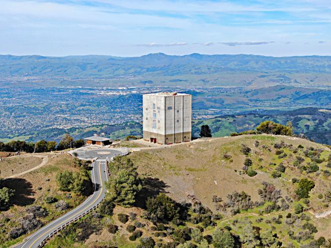
Hicks Road South is the second most difficult bike climb (just behind Hicks Road-Mt. Umunhum North) in Santa Clara County and the Bay Area. The final 4.5 miles of the climb overlap the climb's northern approach and ends at an unmarked high point 1.5 miles before the iconic "Cube" (a five-story Cold War era radio station) which sits atop the mountain. There are exceptional views of the Silicon Valley at the Cube's overlook.

Mt. Umunhum is PJAMM's selection for fifth most scenic bike climb in the Bay Area. The PJAMM Adventure App's preloaded trips for the Bay Area's Top 10 Most Scenic are viewed near the bottom of this page. 
It is likely no surprise that a climb that averages 10% has some very steep segments - the steepest quarter mile is 14% and the steepest mile is 12%.  There is a 300 yard stretch that averages 16.5% beginning at mile 3.8.  42% (2.3 miles) is at grade 5-10%, 45% (2.5 miles) 10-15% and 2% (.1 mile) is at grade 15-20%. 

See more details and tools regarding this climb's grade via the “Profile Tool” button above.
Roadway: The road is in excellent condition as of 2020. 

Traffic: There is very mild traffic for the entire route - traffic is not a problem, this is a peaceful ride - well, other than the suffering. 

Parking: I have always parked at the climb start at the western tip of Almaden Reservoir - Streetview.
No special gear, other than baby gearing if you are, well, like me . . . 
Before heading out on any cycling adventure check out our Things to Bring on a Cycling Trip and use our interactive check list to ensure you don't forget anything.
Booking your travels through one of these links helps us continue to bring you awesome info on climbing and cycling. Thank you! 
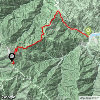
The start points for both Umunhum climbs are very close together. Riding both sides is 21.5 miles and 5,369' (Map). You can begin this climb at Blossom Hill Road in Campbell (about 10 miles from climb start); the road is narrow with no shoulder, but a lot of cyclists do this for the northern climb.

ROUTE MAP

MEMBER RATING

Not Yet Rated
-
Road
-
Traffic
-
Scenery

CURRENT WEATHER

PJAMM TRIPS ADVENTURE STARTER BUNDLES

Check out PJAMM Adventure's prepackaged (self-guided) cycling trips. They will help you plan, document and conquer your next adventure.
ALL TRIPS
Browse all of our prepackaged trips and find your next adventure!
San Francisco Bay Area
United States (CA)
25 ROUTES
30 POIs
ROUTE STATS (TOTAL)
487.9
mi
DISTANCE
65,482
ft
ELEV. GAIN
San Francisco Bay Area: Most Scenic Bike Climbs
United States (CA)
10 ROUTES
0 POIs
ROUTE STATS (TOTAL)
86.9
mi
DISTANCE
25,759
ft
ELEV. GAIN

NEARBY CLIMBS (0) RADIAL PROXIMITY

FROM
No Climbs Found

MEMBER REVIEWS & COMMENTS

Let us know what you thought of this climb. Signup for our FREE membership to write a review or post a comment.
Already have an account?
ROUTE MAP
PROFILE TOOL
Route Data
S.G. (%)
hide
Segment Data
hide

Climb Profile Not Found
CLIMB SUMMARY

Cycling Mt Umunhum  - Mt. Umunhum sign with The Cube in the background.

Cycling Hicks Road, Mt. Umunhum South

Ride 5.5 miles gaining 2,697’ at 9.3% average grade.

Climb summary by PJAMM’s John Johnson.

Center photo is taken with drone above the Cube.

Before heading out to climb Mt. Umunhum, be sure to rely on our list of Things to Bring on a Cycling Trip, and use our interactive checklist to ensure you don't forget anything.

How does Umunhum South rank in Santa Clara County, California, and the United States compared to the other top bike climbs?

  • Difficulty overall:
  • Santa Clara County:  #2 (behind Umunhum North)
  • California:  #54
  • US:  #112

  • Steepest 5 miles:
  • Santa Clara: #2
  • California: #3
  • USA:  #9
  • World: #148


Drone video of The Cube: San Jose, Silicon Valley in background.

Hicks Road South up Mt. Umunhum (Ohlone for "resting place of the hummingbird") is the second most difficult bike climb in Santa Clara County.

Turn onto Mt. Umunhum Road at mile 1.7

PJAMM cyclists on Hicks Road riding bike to Mt Umunhum

Hicks-Umunhum South begins at the western end of Almaden Reservoir.

Mt. Umunhum Road (The Cube in background).

We enter Sierra Azul Open Space Preserve (the route to Mt. Umunhum) at around 1.7 miles from the southern Hicks road start.  From here it is about 4½ more miles to the high point of the climb.  We have great views of the Santa Cruz Mountains to the west and the Silicon Valley, Mt. Hamilton, and the Diablo Mountain Range to the east.  The ranked route ends about 1½ miles from The Cube.  Full routes to The Cube from north and from south are accessed via the links.  When you arrive near the summit, there is a main parking lot for cars but you can go to the right and continue a couple hundred yards up to the handicap parking lot at the top and view The Cube in all its glory.

PJAMM cyclists on Hicks Road riding bike to Mt Umunhum

Mt. Umunhum Road is cycle friendly.

Gettin to The Cube . . .

PJAMM cyclists on on bikes at finish of Mt Umunhum

The Cube, with its angular shape visible from great distances, leaves no doubt where the top of Mt. Umunhum is.

Views from the observation deck next to The Cube.

PJAMM cyclists on Hicks Road riding bike to Mt Umunhum 

Drone video of The Cube -- Silicon Valley in background.

PJAMM cyclists on Hicks Road riding bike to Mt Umunhum

Drone take off from the top of The Cube.

Roadway Surface and Traffic Report:  Hicks Road from the Silicon Valley side is a great ride, though the two lane road is narrow and there is mild traffic with many curves along the way that make it a slightly unsettling climb, particularly if starting from the South Bay.  The Northern side has minimal traffic and is very safe.   Mt. Umunhum has no traffic and is a single lane rough road which was was recently repaved (September 2017) and is in very good condition.  There is moderate traffic from people visiting the summit, but car speeds are low and the ride feels quite safe.


  View on climb by bike up Mt Umunhum - Mt. Hamilton and Lick Observatory in background.

Mt. Umunhum Road just below center of photo;

 Mt. Hamilton (Lick Observatory) is center in mountain range in background.

About the Area:

At 3,486 feet, Mt. Umunhum is one of the highest peaks in the Santa Cruz Mountain Range, and is part of the Sierra Azul Open Space Preserve.  The summit of Mt. Umunhum has been newly restored and revived by the Midpeninsula Open Space District (MOSD), and has been recently reopened for public access.  From the peak beautiful panoramic views of the Pacific Ocean and the Sierra Nevada mountain range can be enjoyed.  Visit MOSD’s website for more information on this unique public space, including the peak’s historical significance as a Native American ceremonial site, and later as an important part of the west coast’s Air Force presence with what is now known as the Mt. Umunhum Cube -- a five story Cold War era radio building built in the early 1960s.

That’s a wrap!!

Access to full Climb Summary requires a PJAMM Cycling PRO Membership!

It takes less than a minute to sign up & with your PRO membership you can:
  • Rate climbs, post comments and share your experiences on any of our climb pages
  • Create bucket lists of climbs & mark the dates you complete them
  • Weather data for all climbs - Start & Finish
  • Upload photos to your member page to customize your PJAMM Cycling experience
  • Utilize all of our interactive tools - Profile & Routes in Area
  • Download climb route .gpx files
LEARN MORE
SIGN UP

Already have an account? LOG IN HERE