
21.1
PDI
7.8 mi
DISTANCE
3,127 ft
GAINED
7.6 %
AVG. GRADE
FULL CLIMB STATS
INTRO
Combe d'Ire climbs 12.5 km (7.8 mi) from Chevaline, in the Bauges above the southern end of Lake Annecy, to around 1491 m (4,891 ft), gaining 953 m (3,127 ft) at a 7.6% average grade. The steepest kilometer averages 12.0% and the steepest 5 km (3.1 mi) 8.5%, so it is hard from the lower slopes onward.
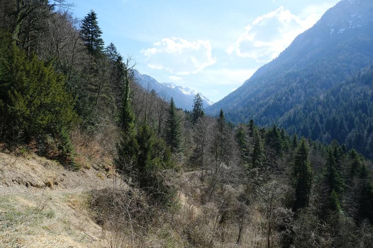
The road follows the Route de Chevaline and then the Chemin de la Grande Combe up a valley beside the Ire stream, through shaded forest with few distant views. The surface starts as asphalt and the upper part is forest track, and reviews describe long sections of broken, poor asphalt, so a gravel or wide-tire bike is far more comfortable than a road bike.
The top of the valley is near the Col de Chérel at 1,495 m (4,905 ft), with views over the Jarsy valley toward the Trélod and Arcalod. The route crosses the Bauges National Hunting and Wildlife Reserve, so this is a quiet, wild corner of the massif rather than a crowded pass.
PLAN YOUR ROUTE
 We've partnered with Sherpa-Map.com to bring you the best route planning tool. With a PRO Membership you can use this climb as a reference when creating your route.
Combe d'Ire covers 12.5 km (7.8 mi) and gains 953 m (3,127 ft) at a 7.6% average grade, from 538 m (1,764 ft) in Chevaline to about 1,491 m (4,891 ft).
The grade is demanding throughout. The steepest 100 yards reach 13.1%, the steepest half mile (0.8 km) averages 12.1%, the steepest kilometer 12.0% and the steepest mile (1.6 km) 11.5%. The steepest 5 km (3.1 mi) averages 8.5%, so even the average stretch is sustained.
Roadway: The road starts as asphalt on the Route de Chevaline and continues as the Chemin de la Grande Combe, a closed road that becomes a forest track higher up. Long sections have poor, sometimes badly deteriorated asphalt, so a gravel or mountain bike is the better choice. It is best ridden outside the winter snow season, and the route passes through a capercaillie winter zone from December to April.
Traffic: Vehicle access is restricted above the Le Martinet parking area, so the upper road is quiet and mostly used by walkers and riders.
Parking: Reach Le Martinet parking area, at about 770 m (2,526 ft), by driving through Doussard and along the D181 to Chevaline and following the forest road signed for the Combe. That lets you skip the first part of the climb, but the full route from Chevaline starts lower, at 538 m (1,764 ft).
Bring everything you need: the upper valley has no services, and the longer gravel loops around here are described as having long sections without them, so carry water and food. The Combe is shaded and cooler than the lake, but the finish near 1491 m (4,891 ft) can be cold and damp, so pack a layer.
A gravel bike or a road bike with wide tires and low gearing suits the broken asphalt and the forest track.
Before heading out on any cycling adventure check out our Things to Bring on a Cycling Trip and use our interactive check list to ensure you don't forget anything.
Doussard, at the foot of the road, is a town of about 3,750 people and a landing field for the many paragliders who take off from the Col de la Forclaz above, so watching them come down is a good way to end the day. A lakeside cycle path runs along Lake Annecy, a flat warm-up or cool-down for a longer day.
Gravel riders can link the Combe d'Ire with the Col de Chérel and Bauges roads on an 85.5 km (53.1 mi) loop from Annecy that passes through Chevaline and returns to Doussard. See our Col de la Forclaz climbs for another way up from the same corner of the lake, and our Routes in the Area tool for other climbs nearby.
ROUTE MAP

MEMBER RATING
CURRENT WEATHER
PJAMM TRIPS ADVENTURE STARTER BUNDLES
Check out PJAMM Adventure's prepackaged (self-guided) cycling trips. They will help you plan, document and conquer your next adventure.
NEARBY CLIMBS (0) RADIAL PROXIMITY
FROM No Climbs Found
MEMBER REVIEWS & COMMENTS
Let us know what you thought of this climb. Signup for our FREE membership to write a review or post a comment.
Already have an account?
LOG IN HERE
