
22.3
PDI
6.8 mi
DISTANCE
3,037 ft
GAINED
8.5 %
AVG. GRADE
FULL CLIMB STATS
INTRO
PLAN YOUR ROUTE
 We've partnered with Sherpa-Map.com to bring you the best route planning tool. With a PRO Membership you can use this climb as a reference when creating your route.
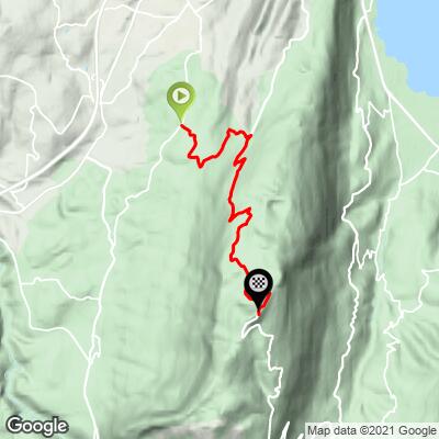
 Semnoz from Quintal climbs 926 m (3,037 ft) over 11.0 km (6.8 mi), from 739 m (2,426 ft) in Quintal to 1,665 m (5,463 ft) on the plateau, at an average grade of 8.5%.
The steepest 100 yards (91 m) reach 16.1%, the steepest quarter mile (0.4 km) averages 13.4%, and the steepest half mile (0.8 km) 11.1%. Over longer blocks it stays hard: 10.5% for the steepest mile (1.6 km), 9.1% for the steepest 2.5 miles (4.0 km) and 8.7% for the steepest 5 miles (8.0 km).
The opening 2 to 3 km (1.2 to 1.9 mi) already carry ramps over 10%, so go out easier than feels natural. After the road merges with the Annecy approach near 1,025 m (3,363 ft) the effort becomes more regular, and the final 2 km (1.2 mi) turn steeper and more irregular again as you approach the station entrance at 1,496 m (4,908 ft).
Roadway: The D241 out of Quintal and the D41 above the merge are paved and in standard departmental condition all the way to the summit. The descent is very technical - steep, with tight turns - so brake early and keep speed in check. The road is open year-round for the Semnoz ski station, so snow and ice are possible outside the May to October riding season.
Traffic: Typically light on the D241 out of Quintal, where the road serves little beyond locals and riders. It picks up after the merge with the main D41 from Annecy, especially on summer weekends, and winter weekends can bring congestion. The road is occasionally closed for cycling events, and Semnoz has been among the cols closed to cars on selected summer mornings (in 2026, on 16 July and 4 August).
Parking: Quintal is a small village, so treat it as ordinary street parking and leave space for residents. Starting here means you avoid the paid-parking changes planned for the summit lot and the D41 described on our Semnoz (Annecy) page. The approach from Annecy runs through Seynod and Vieugy, and from Aix-les-Bains through Alby-sur-Chéran, Le Treige and Vieugy.
Provisions: Quintal is a village rather than a resort, so fill bottles before you start and carry food for the 11.0 km (6.8 mi). The station at the top has restaurants and, in season, alpine farm shops selling local cheese, though hours vary.
Gear: A compact or semi-compact setup with a 32 tooth cog (34x32 or 36x32) is the usual recommendation for the 10%+ ramps. The plateau is cooler and windier than Quintal, and the descent is fast and technical, so bring a wind layer.
Before heading out on any cycling adventure check out our Things to Bring on a Cycling Trip and use our interactive check list to ensure you don't forget anything.
Quintal is a small village at the edge of the Bauges park, with a church dating to the 11th century and an adventure park, Acro' Aventures. It is a very different base from lively Annecy and a good pick if you would rather start a day of climbing from somewhere quiet.
At the top, the hotel-restaurant on the plateau has been serving since 1872, and the Crêt de l'Aigle at 1,646 m (5,400 ft) is the massif's second peak. If you want a different way down or up, the D41/D110 road continues across the crest toward the Col de Leschaux on the far side, and the approach from Annecy is covered on our Semnoz (Annecy) page. The best riding season runs from May through October.
Check current conditions before you go with our Weather tool, since the plateau is often noticeably cooler and windier than the valley.
ROUTE MAP
MEMBER RATING
CURRENT WEATHER
PJAMM TRIPS ADVENTURE STARTER BUNDLES
Check out PJAMM Adventure's prepackaged (self-guided) cycling trips. They will help you plan, document and conquer your next adventure.
NEARBY CLIMBS (0) RADIAL PROXIMITY
FROM No Climbs Found
MEMBER REVIEWS & COMMENTS
Let us know what you thought of this climb. Signup for our FREE membership to write a review or post a comment.
Already have an account?
LOG IN HERE
