Cedar Canyon Bike Climb - PJAMM Cycling

7.7
FIETS
16.7 mi
DISTANCE
4,077 ft
GAINED
4.6 %
AVG. GRADE

FULL CLIMB STATS

Page Contributor(s): Chris Monson, Blanding, UT; Ron Hawks, Las Vegas, NV; Bruce Hamilton, La Quinta, CA; Stacy Topping, Tacoma, WA

INTRO

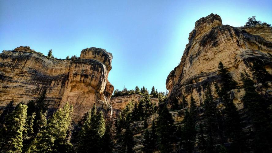
Cedar City, home of the Shakespearean Festival, the Utah Summer Games, and Southern Utah University is the start of this geologically beautiful climb to the high timbers of Dixie National Forest. Starting at about 5,800' Highway 14 begins with 15 miles of climb up through what is commonly referred to as Cedar Canyon. The first few miles follows Coal Creek as it meanders through the cedars of the flat lands of the canyon.
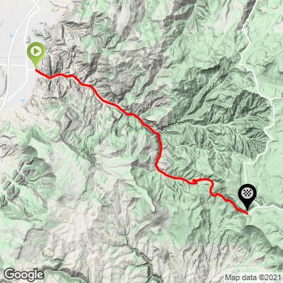
4.6% average grade, gaining 4,100' in 16.7 miles - 48% is at 0-5% grade and 46% is at 5-10%.  The steepest quarter-mile is 9% and steepest mile is 7.9%.  

See more details and tools regarding this climb's grade via the “Profile Tool” button.
Roadway:  Two lane highway in fair to good condition except for some freeze cracks across the road, more frequently encountered higher up the mountain we go.  There is generally no shoulder along the route. 

Traffic:  Mild. 

Parking:  At Canyon Park, East Side parking lot at climb start - MapStreet View
ProvisionsRusty's Ranch House at mile 1.3, Milt's Stage Stop mile 4.5.  

Weather and Gear:  We finish above 9,900', 4,000' above our start.  Therefore, be sure to consult the PJAMM "Full Forecast" feature for the time you expect to arrive at the finish to assess what clothing to bring on your ride.
Before heading out on any cycling adventure check out our Things to Bring on a Cycling Trip and use our interactive check list to ensure you don't forget anything.
This climb can be done along with the spectacular and little known Kolob Canyon Road climb just 20 miles south and on your way to Zion National Park just 58 miles south (by freeway) or 33 miles via the spectacular Kolob Terrace Road route (Google Map).  See our Zion National Park page for more details regarding bike climbs and hikes in Zion NP. 

ROUTE MAP

MEMBER RATING

Not Yet Rated
-
Road
-
Traffic
-
Scenery

CURRENT WEATHER

PJAMM TRIPS ADVENTURE STARTER BUNDLES

Check out PJAMM Adventure's prepackaged (self-guided) cycling trips. They will help you plan, document and conquer your next adventure.
ALL TRIPS
Browse all of our prepackaged trips and find your next adventure!
The American Southwest
United States (AZ,NM,UT)
18 ROUTES
27 POIs
ROUTE STATS (TOTAL)
215.4
mi
DISTANCE
34,866
ft
ELEV. GAIN
Utah: Moab, Arches & Canyonlands
United States (UT)
19 ROUTES
21 POIs
ROUTE STATS (TOTAL)
325.3
mi
DISTANCE
32,871
ft
ELEV. GAIN
Utah: Zion National Park
United States (UT)
20 ROUTES
32 POIs
ROUTE STATS (TOTAL)
256.5
mi
DISTANCE
39,649
ft
ELEV. GAIN

NEARBY CLIMBS (0) RADIAL PROXIMITY

FROM
No Climbs Found

MEMBER REVIEWS & COMMENTS

Let us know what you thought of this climb. Signup for our FREE membership to write a review or post a comment.
Already have an account?
ROUTE MAP
PROFILE TOOL
Route Data
S.G. (%)
hide
Segment Data
hide

Climb Profile Not Found
CLIMB SUMMARY

Cycling Cedar Canyon, Utah -- Ride 16.6 Miles gaining 4,097’ at 4.6%

“Cedar Canyon is a very scenic and steady grade climb that follows a drainage from Cedar City up toward Cedar Breaks National Monument over Route 14. The hill takes you just north of Zion National Park and there are good views in places along the way. Never steep, the grade increases over the second half of the climb before ending at unmarked Midway Summit (9,896 feet). Its descent is a nice one due to mostly gentle curves but keep in mind the road is narrow in places and the road carries some traffic at times.” (This quote is presented with the approval of John Summerson, from his book, The Complete Guide to Climbing (by Bike), 2nd Edition, pg. 222.)

Stacy Topping takes in the gorgeous Autumn colors of Southwestern Utah

Cedar City, Utah -- home of the Shakespearean Festival, the Utah Summer Games, and Southern Utah University -- is the start of this geologically beautiful climb to the high timbers of Dixie National Forest. Starting at about 5,800', Highway 14 begins with 15 miles of climb up through what is commonly referred to as Cedar Canyon. The first few miles follow Coal Creek as the road meanders through the cedars in the flat lands of the canyon. We pass Milt's Stage Stop at mile 4.4, where you can get one of the best steaks in the area -- you know where you'll be eating tonight!  After a few miles you will see a sign warning about falling rock. This is where the 10-11% grades start the heavy lifting of the canyon. You will pass tall vertical cliffs and another branch of the creek (populated by beaver just a few years ago).  

IMG_20160617_160007.jpg   

IMG_20160617_160007.jpg


After coming out of the steep vertical cliffs at mile 10.5, you are in a small valley that hosts Southern Utah University's mountain campus. This spot is where Dixie National Forest begins. Less than a mile after entering the forest, you will pass Cedar Canyon Campground. On the right side of the road, right across from the campground is a small hill with tan rocks that meet the road. If you look very carefully, you can actually see fossils embedded in the rock, telling us of plant life from the Jurassic period. This is also the beginning of the 'S' turn, a tight cornered stretch of road offering great views of  the western edge of Cedar Breaks National Monument. The remaining few miles to the summit will give you very nice views of thousands of acres of the Dixie National Forest wooded wilderness.

IMG_20160618_162740.jpg

IMG_20160617_234118.jpg


On a clear day, from the top of the climb, you’ll be able to make out the spectacular white sandstone cliffs of Zion National Park, some 15-20 miles due south. Cresting the summit at just shy of 10,000',  stop and take the Bristlecone Pine trail to see some
bristlecone pines. These magnificent trees are some of the longest living life forms on earth at some 5,000 years of age.  

IMG_20160618_163943_Zion_Overlook.jpg   

  IMG_20160618_230003_Summit.jpg


Steepest ¼ mile begins at mile 13.6 (8.9%) and steepest mile at 12.9 (7.7%)

Roadway Surface and Traffic Report: The roadway surface is excellent throughout this climb.  There is often no shoulder as we climb deeper into the canyons and there is a fair bit of traffic along this very scenic route, particularly on weekends.

IMG_20160617_160007.jpg

Thank you Ron!!

IMG_20160617_160007.jpg

Thank you Stacy!!