
18.4
PDI
6.6 mi
DISTANCE
2,710 ft
GAINED
7.8 %
AVG. GRADE
FULL CLIMB STATS
INTRO
PLAN YOUR ROUTE
 We've partnered with Sherpa-Map.com to bring you the best route planning tool. With a PRO Membership you can use this climb as a reference when creating your route.
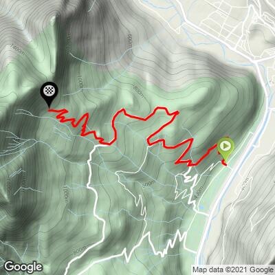
The Montée de Marthod averages 7.8% over 10.6 km (6.6 mi), but it rides like two climbs. The first 7 km (4.3 mi), up through Marthod and the hamlets, sit mostly between 6% and 8.5%, with two easier kilometers at around 4.6-5.6% as the road threads between farms - the place to settle into a rhythm.
From the turn at Chantemerle the forest road gets serious. Kilometers 8, 9 and 10 each average 9.3-9.4%, and the final half kilometer climbs at 10.5%. The steepest 500 m (0.3 mi) averages 12.8%, the steepest 1 km (0.6 mi) 11.6%, the steepest 2 km (1.2 mi) 10.0% and the steepest 5 km (3.1 mi) 8.8%. Riders report short ramps above 14% near the top, and the last few hundred meters are unpaved, so save something for the finish.
Roadway: The road is paved from the valley through Marthod and the hamlets, but it is narrow and winding, and rider reports describe the asphalt as only fair and getting rougher the higher you go. Above the Chantemerle turnoff it becomes a narrow forest road with little signage beyond the sign at the turn, and the final few hundred meters to the parking area are unpaved and loose enough that riders say standing on the pedals is not an option. The top section is a summer access road to the Alpettaz trailhead (there is a separate winter parking area about 1 km lower), so treat this as a late-spring to autumn ride and take the descent carefully.
Traffic: Light. Expect local traffic through Marthod and the hamlets, then very little above Chantemerle beyond the occasional car heading for the trailhead parking.
Parking: The climb starts down on the valley floor, so the simplest approach is to ride in from Albertville or Ugine - the Belle Via cycle route between Annecy and Albertville runs through this stretch of the valley. At the top, the Parking du Raffort (about 1,190 m / 3,904 ft) is the trailhead for the Fort de la Batterie and the Dent de Cons loop.
Provisions: Fill your bottles in the valley or in Marthod - there is nothing to buy on the upper road. Volunteers sometimes run a refreshment stand at the Fort de la Batterie when it is open, but don't plan your ride around it.
Gear: A compact crankset with a 32- or 34-tooth cog is worth having for the final 3.5 km (2.2 mi) near 10% and the short ramps above 14%. Slightly wider tires help on the rough upper asphalt and the unpaved finish, and good brakes matter on the steep, narrow descent. Shade is scarce on the lower half, so start early in midsummer, and if you plan to walk to the fort, bring shoes you can hike 40 minutes in.
Before heading out on any cycling adventure check out our Things to Bring on a Cycling Trip and use our interactive check list to ensure you don't forget anything.
Marthod is a small village on the slope above the Arly, between Albertville and Ugine. Our Col des Cyclotouristes page covers Albertville's medieval Conflans quarter, and our two Col de l'Arpettaz pages cover Ugine and the refuge at that col, so this page sticks to what is unique to this side of the valley.
The Fort de la Batterie is the headline. It was built under General Séré de Rivières' fortification program after the 1870 war, with embrasures for mountain guns and barracks for an officer and 85 men, and it never saw combat. Since 1998 the volunteer association "Pour que vive le Fort de la Batterie" has been bringing it back from ruin. It opens on weekends from May through October, entry is free, and the view runs across the Ugine valley to the Mont Blanc massif. It is about 40 minutes on foot from the parking area at the top of the climb, and hikers can continue to the 2,063 m (6,768 ft) Dent de Cons and its viewing table.
For a shorter add-on, the Col du Vorger is a steep little climb from Marthod with numbered hairpins and kilometer markers painted by the village children. See other climbs nearby, or build a custom route from here, with our Routes in the Area tool.
ROUTE MAP
MEMBER RATING
CURRENT WEATHER
PJAMM TRIPS ADVENTURE STARTER BUNDLES
Check out PJAMM Adventure's prepackaged (self-guided) cycling trips. They will help you plan, document and conquer your next adventure.
NEARBY CLIMBS (0) RADIAL PROXIMITY
FROM No Climbs Found
MEMBER REVIEWS & COMMENTS
Let us know what you thought of this climb. Signup for our FREE membership to write a review or post a comment.
Already have an account?
LOG IN HERE
