
21.4
PDI
13 mi
DISTANCE
3,914 ft
GAINED
5.5 %
AVG. GRADE
FULL CLIMB STATS
INTRO
PLAN YOUR ROUTE
 We've partnered with Sherpa-Map.com to bring you the best route planning tool. With a PRO Membership you can use this climb as a reference when creating your route.
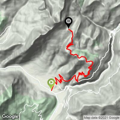
Col de l'Arpettaz Est covers 20.9 km (13.0 mi) and gains 1,193 m (3,914 ft) in total, rising from 420 m (1,378 ft) in Ugine to 1,576 m (5,172 ft) at the col, a net climb of 1,156 m (3,794 ft) at an average grade of 5.5%.
That average is gentle for an Alpine pass, but the harder stretches are well above it: the steepest 10 km average 7.2%, the steepest 5 km 8.7%, the steepest 2 km 9.4% and the steepest kilometer 10.0%. The steepest 500 m averages 10.6%, and the steepest 91 m (100 yd) reaches 12.6%.
By comparison, our shorter Mont Dessous route to the same col runs 15.1 km (9.4 mi) at 7.5%. This one trades distance for a steadier effort.
Roadway: The road is paved the entire way from Ugine to the col. Riders describe the surface as only average in places, with rough patches and some narrow stretches, and it matters more on the descent than on the way up. This is a summer-season road: the refuge at the top is reached by car in summer but only on snowshoes or skis in winter, so plan it as a late-spring to early-autumn ride.
Traffic: Very light. Riders consistently report very little traffic on this route, mostly residents, farm vehicles and summer visitors heading to the refuge.
Parking: The climb starts in Ugine itself, so leave your car in town - street parking near the center is the practical choice, and it is shared with our Mont Dessous route. If you would rather start from the Lake Annecy side, Faverges-Seythenex (520 m / 1,706 ft) is the base for a longer 66 km (41.0 mi) out-and-back to the col.
Provisions: Stock up in Ugine before you start - there is nothing to buy between town and the col. At the top, the Refuge de l'Arpettaz serves meals (see Travel Tips), so you can plan a real stop there instead of carrying everything.
Gear: With 10% pitches in the upper half and a 5.5% average over 20.9 km (13.0 mi), a compact crankset with a 28-tooth or larger cog keeps the climb comfortable. The pavement is patchy, so slightly wider tires help, and check your brakes before the descent.
Weather: The col sits near 1,580 m (5,184 ft), so pack a windproof layer even when Ugine is warm.
Before heading out on any cycling adventure check out our Things to Bring on a Cycling Trip and use our interactive check list to ensure you don't forget anything.
Ugine is a working town in the Arly valley rather than a resort, so the trip is about what you string together from it. The Val d'Arly tourist office publishes a 74 km (46.0 mi) loop with about 2,300 m (7,546 ft) of climbing - La Giettaz, Flumet, Crest-Voland, Cohennoz, Ugine, the Arpettaz, Héry-sur-Ugine and back to Flumet - with the Arpettaz as the long climb in the middle. From the Lake Annecy side, the Haute-Savoie Mont-Blanc tourist board lists a 66 km (41.0 mi) out-and-back from Faverges-Seythenex, rated very difficult, with a cool-off stop near Lac de Marlens on the way back.
The Refuge de l'Arpettaz at the col (1,581 m / 5,187 ft) is a staffed mountain inn with dorm and private rooms and evening meals, and its tourist-board listing shows it open year-round (snowshoes or skis in winter), so riding up for lunch or staying overnight is realistic. It is reachable by car in summer from Ugine, Héry-sur-Ugine and the Col des Aravis - check opening dates at refugearpettaz.com before you plan around it.
Our Col de la Forclaz West, Col des Saisies North and Route d'Héry pages start from the same valley if you are staying a few days. Conditions at the col can differ a lot from the valley floor, so check them with our Weather tool before you set out.
ROUTE MAP
MEMBER RATING
CURRENT WEATHER
PJAMM TRIPS ADVENTURE STARTER BUNDLES
Check out PJAMM Adventure's prepackaged (self-guided) cycling trips. They will help you plan, document and conquer your next adventure.
NEARBY CLIMBS (0) RADIAL PROXIMITY
FROM No Climbs Found
MEMBER REVIEWS & COMMENTS
Let us know what you thought of this climb. Signup for our FREE membership to write a review or post a comment.
Already have an account?
LOG IN HERE
