Cedar and Right Hand Canyon Roads Bike Climb - PJAMM Cycling

19.2
PDI
12.4 mi
DISTANCE
3,358 ft
GAINED
5.1 %
AVG. GRADE

FULL CLIMB STATS

Page Contributor(s): Chris Monson, Blanding, Utah, USA

INTRO

This 12.4 mile bike climb is located in UT, USA. The average gradient is 5.1% and there is a total elevation gain of 3,358 ft, finishing at 9,172 ft.

Use the profile tool, route map, and weather forecast to conquer this cycling climb.

See more details and tools regarding this climb's grade via our interactive Profile Tool.
Information Not Available

If you have any information regarding this climb, we'd like to hear from you. Click the CONTRIBUTE button to share your thoughts with us.

Information Not Available

If you have any information regarding this climb, we'd like to hear from you. Click the CONTRIBUTE button to share your thoughts with us.

Before heading out on any cycling adventure check out our Things to Bring on a Cycling Trip and use our interactive check list to ensure you don't forget anything.
Information Not Available

If you have any information regarding this climb, we'd like to hear from you. Click the CONTRIBUTE button to share your thoughts with us.

ROUTE MAP

MEMBER RATING

Difficulty: Challenging
3
Road
4
Traffic
3
Scenery

CURRENT WEATHER

PJAMM TRIPS ADVENTURE STARTER BUNDLES

Check out PJAMM Adventure's prepackaged (self-guided) cycling trips. They will help you plan, document and conquer your next adventure.
ALL TRIPS
Browse all of our prepackaged trips and find your next adventure!
The American Southwest
United States (AZ,NM,UT)
18 ROUTES
27 POIs
ROUTE STATS (TOTAL)
215.4
mi
DISTANCE
34,866
ft
ELEV. GAIN
Utah: Moab, Arches & Canyonlands
United States (UT)
19 ROUTES
21 POIs
ROUTE STATS (TOTAL)
325.3
mi
DISTANCE
32,871
ft
ELEV. GAIN
Utah: Zion National Park
United States (UT)
20 ROUTES
32 POIs
ROUTE STATS (TOTAL)
256.5
mi
DISTANCE
39,649
ft
ELEV. GAIN

NEARBY CLIMBS (0) RADIAL PROXIMITY

FROM
No Climbs Found

MEMBER REVIEWS & COMMENTS

Let us know what you thought of this climb. Signup for our FREE membership to write a review or post a comment.
Already have an account?

Mar 26, 2021
difficulty: Challenging
scenery: 3
traffic: 4
road: 3
Mar 26, 2021
scenery: 3
traffic: 4
road: 3
The climb of Cedar/Right Hand Cyns is a good one with enough length and elevation gain to test you. Deal with the traffic on Route 14 (Cedar Canyon) as once you turn into Right Hand it disappears and the grade increases. Nice turns and long views higher up. You ride through an aspen forest near the summit just north of Zion NP. A good climb.
ROUTE MAP
PROFILE TOOL
Route Data
S.G. (%)
hide
Segment Data
hide
CLIMB SUMMARY

IMG_20160618_231043.jpg

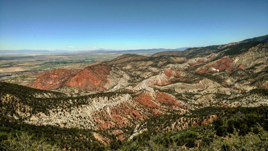
Right Hand Canyon - a fork off of Hwy 14 in Cedar Canyon is the home of the climbing competition of the Utah Summer Games out of Cedar City Utah.  

While a bit less altitude gained on this climb than it's sister climb (the full Cedar Canyon ascent), we do gain 3,300' and the steep grades of this challenging climb are more sustained than on Cedar Canyon.  After the first few miles climbing into the deep canyon, we are on the southwest precipice of Lone Tree Mountain the remainder of the climb which affords sustained impressive views of the western plains (Cedar City, Hamiltons Fort) to the right.   At the end of a long sweeping left curve (miles 8-9) we are traveling south and pass a small unnamed mountain community of about a dozen houses - the view from here explains why houses were built in such a remote area of southern Utah. Miles 10-11 are a couple of challenging switchbacks which give us a great view back of the road which we have traveled (we love switchback back views).  We end in a beautiful aspen lined meadow - if luck serves, you may see elk grazing in this area.

IMG_20160618_230334.jpg 

   IMG_20160618_230857.jpg

Roadway surface and traffic:  There is a fair amount of traffic along a very nice road for the first 4.4 miles of the climb.  The pavement after turning onto Right Hand Canyon remains good and the traffic decreases to very light - this is a very safe and enjoyable ride.