
25.1
PDI
9.4 mi
DISTANCE
3,745 ft
GAINED
7.5 %
AVG. GRADE
FULL CLIMB STATS
INTRO
Col de l'Arpettaz is a 1577 m pass in the Aravis range of the French Alps, tucked into Savoie between Mont Charvin and the Praz Vechin ridge above the small town of Ugine. The direct route from Ugine via Mont Dessous covers 15.1 km (9.4 mi) and climbs 1142 m (3,745 ft) at an average grade of 7.5%, with the steepest kilometer touching 9.3% and a steepest 100-yard ramp of 10.5%.
What makes this climb distinctive is how little company you'll have on it.
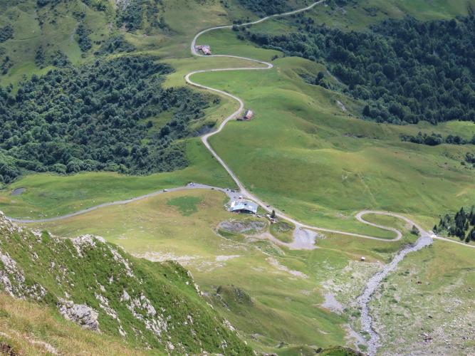
The road switches back through dense forest - riders count roughly 40 hairpins - before breaking into open alpine pasture for the final kilometers, where dairy cows graze meadows that produce the region's Reblochon cheese. Traffic is close to nonexistent; a vehicle you meet is more likely a farm tractor than a car. From the summit, the view opens across the Aravis chain to Mont Charvin and, on a clear day, Mont Blanc.
This is a genuinely obscure col - never used in the Tour de France, Giro, or Vuelta - though it has appeared as a timed climb in L'Étape du Tour, the amateur cyclosportive. The pavement is the honest downside: rougher and more patched than a typical French Alpine road, especially in the upper kilometers, and riders consistently note it's friendlier to climb than to descend.
PLAN YOUR ROUTE
 We've partnered with Sherpa-Map.com to bring you the best route planning tool. With a PRO Membership you can use this climb as a reference when creating your route.
 From Ugine via Mont Dessous, Col de l'Arpettaz runs 15.1 km (9.4 mi) and gains 1,142 m (3,745 ft) at an average grade of 7.5%. The climb starts at 443 m (1,454 ft) and tops out at the col at 1,577 m (5,173 ft).
The gradient is fairly consistent once past the first few kilometers out of Ugine - most of the middle and upper sections sit in the 7-9% range with short steeper ramps in the switchbacks. The steepest kilometer averages 9.3%, and the steepest 100-yard stretch hits 10.5%. There's no long flat or descending section to recover on before the summit.
World rank: 544.
Roadway: The road is paved the entire way from Ugine, but the surface is noticeably rougher than a typical French Alpine col - patched, uneven in places, and prone to loose gravel and small debris washed down from the forest, especially in the upper kilometers above Mont Dessous. Multiple rider reports through 2025 describe the same long-standing condition rather than any sudden new damage, and the road remains open with no known closures; it's consistently described as a friendlier surface to climb than to descend.
Traffic: Traffic is minimal to nonexistent for the entire climb. This is a quiet farm and pasture road above Ugine - the occasional vehicle is far more likely to be a tractor or livestock trailer than a car, and several riders report meeting no other traffic at all.
Parking: Ugine is a small industrial town in the Arly valley with ordinary street parking near the town center; there's no dedicated trailhead lot since the climb starts right from town. Riders commonly stage near the town center roundabout before heading out on the D109 toward Mont Dessous.
Ugine has a supermarket and bakeries for a last real food and water stop - once you leave town there's nothing until the col itself. A small refuge near the summit has offered seasonal refreshments to riders in the past, but it's not a reliable stop to plan around.
Given the rough, patched pavement in the upper kilometers, slightly wider tires and a bit of extra tire pressure margin are worth having over a typical smooth Alpine col. The descent is technical and the surface deteriorates further in spots, so check your brake pads beforehand and carry a layer - at 1,577 m even a summer summit can be noticeably cooler and windier than the valley floor.
Before heading out on any cycling adventure check out our Things to Bring on a Cycling Trip and use our interactive check list to ensure you don't forget anything.
Ugine sits in the Arly valley between Albertville and Annecy, in the heart of Reblochon cheese country - the alpine pastures the climb passes through are part of the same dairy tradition. It's a working town rather than a resort, so don't expect a tourist infrastructure at the base; most visitors are passing through en route to bigger destinations in the Aravis or Beaufortain.
The immediate area is dense with other cols worth combining into a longer day - Col des Aravis, Col de la Croix Fry, and Col des Saisies are all within a short drive of Ugine, and several riders descend the Arpettaz's quieter eastern side toward Héry-sur-Ugine to loop back into town rather than retracing their route. Our Routes in the Area tool is a good way to see what else nearby is worth riding.
There's no dedicated cyclist parking or bike shop confirmed in Ugine itself, so come prepared - the nearest full-service bike shops are in Albertville or Annecy.
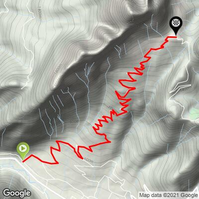
ROUTE MAP
MEMBER RATING
CURRENT WEATHER
PJAMM TRIPS ADVENTURE STARTER BUNDLES
Check out PJAMM Adventure's prepackaged (self-guided) cycling trips. They will help you plan, document and conquer your next adventure.
NEARBY CLIMBS (0) RADIAL PROXIMITY
FROM No Climbs Found
MEMBER REVIEWS & COMMENTS
Let us know what you thought of this climb. Signup for our FREE membership to write a review or post a comment.
Already have an account?
LOG IN HERE
