
16.8
PDI
5.2 mi
DISTANCE
2,321 ft
GAINED
8.4 %
AVG. GRADE
FULL CLIMB STATS
INTRO
PLAN YOUR ROUTE
 We've partnered with Sherpa-Map.com to bring you the best route planning tool. With a PRO Membership you can use this climb as a reference when creating your route.
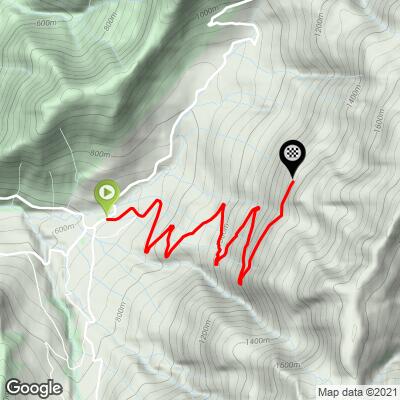
From 637 m (2090 ft) at the top of Theys to 1339 m (4393 ft) at Les Quatre Chemins, the climb covers 8.3 km (5.2 mi) and gains 707 m (2321 ft) at an average of 8.4%. The steepest kilometer averages 11.4%, the steepest 2 km 9.5% and the steepest 5 km 9.1%.
Km 0-3: 8.5%, out of Theys past the last houses and meadows and into the forest.
Km 3-7: 8.8%, the heart of the climb, all in the woods; the hardest kilometer comes between about km 4.5 and 5.5.
Km 7-8.3: 7.2%, a slight easing up to the crossroads where the asphalt ends.
Roadway: Paved as far as Les Quatre Chemins, where the road ends and unpaved forest tracks begin. It's a narrow mountain road without a center line, mostly in forest, so expect leaves, gravel and damp patches in the shaded corners, especially on the way down. It's a dead end - you come back the same way. At this height snow lingers in the woods well into spring.
Traffic: Very light. Above the first houses the road serves little more than forestry work and walkers heading for the trails at Les Quatre Chemins, so the odd car or forestry vehicle is all you're likely to meet.
Parking: Theys has several free car parks in the village center, a couple of hundred meters below the start (map). Ride up the Route du Col du Barioz from the center and turn onto the Route du Replat. There's no parking worth driving to at the top.
Gear: With 8 to 9% almost the whole way and a kilometer near 11%, bring your lowest gear - a 34x32 is not overkill. The descent is long, steep and narrow, so check your brakes before you start.
Provisions: Everything is in Theys: a bakery, a café and a couple of restaurants around the center, plus public toilets and a fountain. Above the village there's nothing at all, so start with full bottles.
Before heading out on any cycling adventure check out our Things to Bring on a Cycling Trip and use our interactive check list to ensure you don't forget anything.
Theys sits on the Balcons de Belledonne, the shelf of villages and hamlets above the Grésivaudan valley northeast of Grenoble, and it's a good place to string short, steep climbs together. Our Station du Barioz pages climb to the Nordic area from Tencin, Saint-Pierre-d'Allevard and Le Cheylas, and the Col du Barioz road from Theys links you to the Allevard side, so a figure-of-eight ride with this climb as the finale is easy to build.
The village itself is old and quiet, with a castle, a church, a former convent and medieval houses that you can see on a short heritage walk from the center. Theys is also one of the three communes behind the Sept Laux ski resort higher up the massif. For maps and walking routes from Les Quatre Chemins, the Belledonne Chartreuse tourist office in Allevard-les-Bains covers the area.
ROUTE MAP
MEMBER RATING
CURRENT WEATHER
PJAMM TRIPS ADVENTURE STARTER BUNDLES
Check out PJAMM Adventure's prepackaged (self-guided) cycling trips. They will help you plan, document and conquer your next adventure.
NEARBY CLIMBS (0) RADIAL PROXIMITY
FROM No Climbs Found
MEMBER REVIEWS & COMMENTS
Let us know what you thought of this climb. Signup for our FREE membership to write a review or post a comment.
Already have an account?
LOG IN HERE
